297 Hempstead Road, Watford, WD17 3NL
About 297 Hempstead Road
297 Hempstead Road is a three-bedroom semi-detached house in Watford (WD17 3NL). It has a recorded floor area of 74 m² (around 797 sq ft), construction records dating it to 1930-1949 and council tax band E. The latest certificate (May 2022) shows a D (score 67), on the cusp of jumping into the C band. The rating has held steady at D across 2 certificates since February 2012. Between certificates, lighting went from Very Poor to Very Good; while roof efficiency dropped from Very Good to Good and window efficiency dropped from Good to Average. The recommended improvements would lift it to B (score 86), a 2-band jump. Our model identifies extension potential, subject to local planning policy.
2 planning records sit against the property, 0 approved, 0 refused, 1 pending. An active application for an extension is awaiting a decision. Today's modelled estimate of £646,000 is 18.5% above the 2022 sale price. On a £-per-square-foot basis, the last sale (£684/sq ft) was about 59.5% above the typical sold price in the postcode. At 74 m² it's 27.8% smaller than the typical home in the postcode (103 m² median across 8 EPCs). Most recent transfer: December 2022 at £545,000. That sale was during the post-pandemic price surge, when transactions cleared materially above pre-2020 trend.
What this property has
Inside
- Bedrooms3
- Bathrooms1
- EnsuiteYes
- FireplaceYes
Outside
- Private gardenRear
- GarageYes
Building
- Extension potentialPossible
Everything you need to know about 297 Hempstead Road
The true value, the hidden risks and the full sale history, in one report.
30-day money-back guarantee

The data behind every report


Energy performance
Recommended upgrades on file would lift this property by multiple EPC bands.
EPC Rating
Property Improvements
Changes detected from historical EPC data
More low energy lighting installed
Planning history
An application for a single-storey side and rear extension is currently awaiting a decision.
- Dec 2024ExtensionFullIn report
Extension: Single storey · Side and rear of property
Erection of a single storey side and part rear extension and 2no roof lights
- Documents
- 7 docs on file
- Reference
- 24/01188/FULH
- Oct 2025ExtensionFullIn report
Extension: Single storey · Side and rear of property
Erection of a single storey side and rear extension and 1no roof light
- Documents
- 14 docs on file
- Reference
- 25/00650/FULH
We flagged 1 thing worth checking at 297 Hempstead Road
Independent checks surfaced things a buyer would want to understand before offering. The report explains each one in full, with the underlying data and what to ask.
- Larger development activity nearby
30-day money-back guarantee
Sales history & valuation
The latest sale landed in the post-pandemic price surge — useful context when reading the figure.
£646,000
Modelled from EPC, postcode comparables.
£545,000
Recorded with HM Land Registry.
Sales timeline
20 December 2022Most recent
£545,000
Median price across the last 5 sales in WD17 3NL: £890,000 (2021–2007).
Nearby sales in WD17 3NL
Grove Wharf House, Hempstead Road, Watford, WD17 3NL
Sold Oct 2021
£1,075,000301 Hempstead Road, Watford, WD17 3NL
Sold Nov 2020
£605,0001 Grove Wharf, Hempstead Road, Watford, WD17 3NL
Sold Mar 2017
£370,000Rose Barn, Hempstead Road, Watford, WD17 3NL
Sold Mar 2012
£900,000Lady Capels Cottage, Hempstead Road, Watford, WD17 3NL
Sold Sept 2007
£890,000
Versus other Hempstead Road homes
297 Hempstead Road is notably below the street on years held.
Price per m²
£7,365
Street avg £6,414
Floor Area
74 m²
Street avg 159 m²
Habitable Rooms
5 rooms
Street avg 5 rooms
CO₂ Emissions
3.0 t/year
Street avg 5.2 t/year
Everything you need to know about 297 Hempstead Road
The true value, the hidden risks and the full sale history, in one report.
30-day money-back guarantee
The data behind every report
Similar properties nearby
The neighbourhood at a glance
Crime
10/mo
Steady year-on-year across the wider district.
Nearest stop
0.2 km
Russell Lane — bus stop.
Closest school
0.3 km
Holy Rood Catholic Primary School. 21 schools nearby.
Go deeper on the local area
The full report breaks down crime, transport links, schools and air quality in depth.
Road noise across the postcode
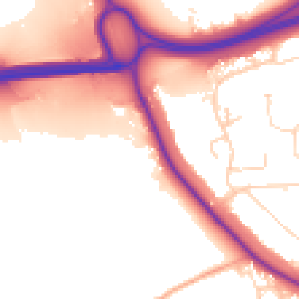
Daytime· 07:00 – 23:00
55.4dB

Night-time· 23:00 – 07:00
48.0dB