13 Hayfield Road, Woolston, Warrington, WA1 4PE
About 13 Hayfield Road
13 Hayfield Road is a semi-detached house in Woolston, Warrington, Warrington (WA1 4PE). It has a recorded floor area of 109 m² (around 1173 sq ft), construction records dating it to 1930-1949 and council tax band C. The latest certificate (April 2018) shows a D (score 61), on the cusp of jumping into the C band. The recommended improvements would push it to C (score 79).
Today's modelled estimate of £274,000 is 21.8% above the 2018 sale price. On a £-per-square-foot basis, the last sale (£192/sq ft) was about 27.5% above the typical sold price in the postcode. Most recent transfer: July 2018 at £225,000.
Everything you need to know about 13 Hayfield Road
The true value, the hidden risks and the full sale history, in one report.
30-day money-back guarantee

The data behind every report


Energy performance
EPC Rating
Planning history
13 Hayfield Road has no planning applications on record.
Notable planning nearby
3applications of note in the surrounding area
We flagged 1 thing worth checking at 13 Hayfield Road
Independent checks surfaced things a buyer would want to understand before offering. The report explains each one in full, with the underlying data and what to ask.
- Larger development activity nearby
30-day money-back guarantee
Sales history & valuation
Latest sale on 13 Hayfield Road was the highest on Land Registry record across the postcode.
£274,000
Modelled from EPC, postcode comparables.
£225,000
Recorded with HM Land Registry.
Sales timeline
30 July 2018Most recent
£225,000
Median price across the last 5 sales in WA1 4PE: £190,000 (2024–2009).
Nearby sales in WA1 4PE
9 Hayfield Road, Woolston, Warrington, WA1 4PE
Sold Oct 2024
£201,00025 Hayfield Road, Woolston, Warrington, WA1 4PE
Sold Jan 2023
£190,00017 Hayfield Road, Woolston, Warrington, WA1 4PE
Sold May 2016
£198,50023 Hayfield Road, Woolston, Warrington, WA1 4PE
Sold Jun 2015
£187,00026 Hayfield Road, Woolston, Warrington, WA1 4PE
Sold Dec 2009
£95,000
Versus other Hayfield Road homes
13 Hayfield Road outperforms the street on price per m² by a wide margin.
Price per m²
£2,064
Street avg £1,470
Floor Area
109 m²
Street avg 99 m²
Habitable Rooms
7 rooms
Street avg 6 rooms
CO₂ Emissions
4.7 t/year
Street avg 4.1 t/year
Everything you need to know about 13 Hayfield Road
The true value, the hidden risks and the full sale history, in one report.
30-day money-back guarantee
The data behind every report
Similar properties nearby
1 Ascot Close, Woolston
WA1 4HE
1 Clifton Close, Woolston
WA1 4BE
1 Epping Drive, Woolston
WA1 4QL
1 Berkshire Drive, Woolston
WA1 4EX
1 Elm Tree Avenue, Padgate
WA1 4HZ
1 Firtree Avenue, Padgate
WA1 4HY
1 Elizabeth Drive, Padgate
WA1 4JQ
1 Baron Close, Woolston
WA1 4EU
The neighbourhood at a glance
Crime
3/mo
Steady year-on-year across the wider district.
Nearest stop
0.1 km
Barnfield Road — bus stop.
Closest school
0.1 km
Woolston Community Primary School. 25 schools nearby.
Go deeper on the local area
The full report breaks down crime, transport links, schools and air quality in depth.
Road noise across the postcode
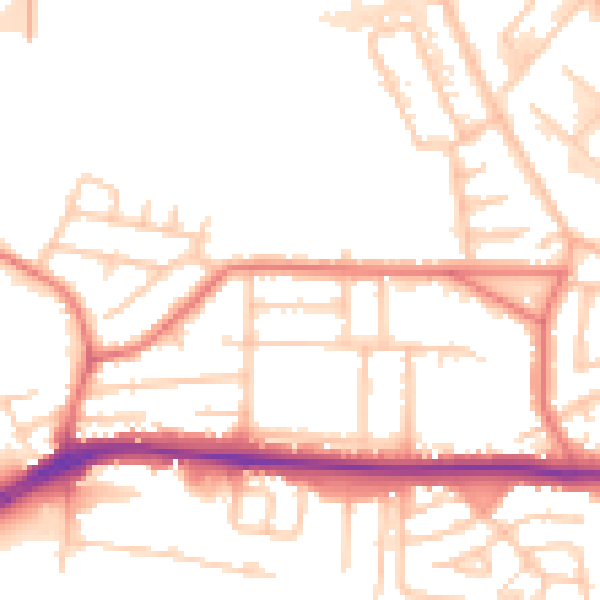
Daytime· 07:00 – 23:00
53.6dB

Night-time· 23:00 – 07:00
44.8dB