18 Montfort Road, Kemsing, Sevenoaks, TN15 6SA
About 18 Montfort Road
18 Montfort Road is a semi-detached house in Kemsing, Sevenoaks, Sevenoaks (TN15 6SA). It has a recorded floor area of 105 m² (around 1130 sq ft), construction records dating it to 1950-1966 and council tax band D. The latest certificate (May 2016) shows an E (score 51), well below the UK norm with real room to improve. The recommended improvements would lift it to B (score 85), a 3-band jump. The latest certificate is from May 2016, so improvements made since then won't be reflected.
At 105 m² it's 17.6% larger than the typical home in the postcode (89 m² median across 8 EPCs). It lags the bulk of the postcode on energy efficiency (less efficient than 88% of similar EPCs).
Know exactly what you're buying at 18 Montfort Road
Before you offer, see what the listing won't tell you, the true value, the red flags and the full history.
Valuation
against the asking price
Risks
planning & flood
Sold prices
similar homes nearby
Trends
the local market
Energy performance
18 Montfort Road's carbon output runs well above what efficient homes in the postcode produce.
EPC Expired
This certificate is over 10 years old and is no longer valid.Expired 30 May 2026
EPC Rating
Planning history
18 Montfort Road has no planning applications on record.
The full report still covers planning activity across the surrounding area.
Sales history & valuation
18 Montfort Road has no Land Registry sales on file, suggesting it has stayed in the same hands since registration began.
£515,000
Modelled from EPC, postcode comparables.
No sales recorded with HM Land Registry
That can mean the property has never traded since the registry began publishing in 1995, was a new build that hasn't been registered yet, or is held in the same hands long-term.
Median price across the last 5 sales in TN15 6SA: £380,000 (2025–2018).
Nearby sales in TN15 6SA
19 Montfort Road, Kemsing, Sevenoaks, TN15 6SA
Sold Jul 2025
£570,00020 Montfort Road, Kemsing, Sevenoaks, TN15 6SA
Sold Dec 2022
£430,00021 Montfort Road, Kemsing, Sevenoaks, TN15 6SA
Sold Jun 2022
£220,0009 Montfort Road, Kemsing, Sevenoaks, TN15 6SA
Sold May 2020
£380,00016 Montfort Road, Kemsing, Sevenoaks, TN15 6SA
Sold Apr 2018
£350,000
Everything we know about 18 Montfort Road, in one report
What it's really worth, what could be wrong, and the planning, sales and area data in full.
- Am I paying too much?
- Is something wrong with it?
- Is the agent's story true?
- Will it hold its value?

Versus other Montfort Road homes
On co₂ emissions, 18 Montfort Road runs well behind the street norm.
EPC Rating
51 (E)
Street avg 65 (D)
Floor Area
105 m²
Street avg 96 m²
CO₂ Emissions
6.8 t/year
Street avg 3.9 t/year
Habitable Rooms
5 rooms
Street avg 5 rooms
Similar properties nearby
1 Ash Tree Close, West Kingsdown
TN15 6JA
1 Blackberry Barn, Birchin Cross Road, Knatts Valley
TN15 6XH
1 Ash Tree Court, Ash Tree Drive, West Kingsdown
TN15 6LT
1 Astor Road, West Kingsdown
TN15 6HH
1 Brookfield, Kemsing
TN15 6SQ
1 Cleves Road, Kemsing
TN15 6RX
1 Boleyn Road, Kemsing
TN15 6RY
1 Church Road, West Kingsdown
TN15 6LL
The neighbourhood at a glance
Crime
3/mo
Steady year-on-year across the wider district.
Nearest stop
0.2 km
Castle Drive — bus stop.
Closest school
1.2 km
Kemsing Primary School. 7 schools nearby.
Go deeper on the local area
The full report breaks down crime, transport links, schools and air quality in depth.
Road noise across the postcode
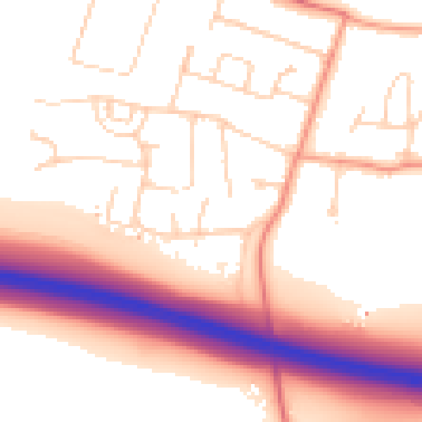
Daytime· 07:00 – 23:00
54.5dB

Night-time· 23:00 – 07:00
47.2dB