15 Lees Road, Bramhall, Stockport, SK7 1BT
About 15 Lees Road
15 Lees Road is a semi-detached house in Bramhall, Stockport, Stockport (SK7 1BT). It has a recorded floor area of 185 m² (around 1991 sq ft), construction records dating it to 1900-1929 and council tax band F. The latest certificate (November 2014) shows a D (score 65), on the cusp of jumping into the C band. The rating has held steady at D across 2 certificates since October 2014. Between certificates, wall efficiency went from Poor to Good. The recommended improvements would push it to C (score 79). The latest certificate is from November 2014, so improvements made since then won't be reflected.
3 planning records sit against the property, 3 approved, 0 refused. Past consents include tree works, meaningful when judging how the property has evolved.
Everything you need to know about 15 Lees Road
The true value, the hidden risks and the full sale history, in one report.
Pick your report · from £14.99
One time fee only - money back guarantee

The data behind every report


Energy performance
15 Lees Road's carbon output runs well above what efficient homes in the postcode produce.
EPC Expired
This certificate is over 10 years old and is no longer valid.Expired 10 Nov 2024
EPC Rating
Certificate validity
Expired on 10 November 2024
Property Improvements
Changes detected from historical EPC data
Cavity wall insulation installed

Get a survey for this property
Level 3 Building Survey
Because the property was built before 1919, we believe a Level 3 building survey should be considered.
From £1,360 · Includes VAT
Planning history
Planning history at 15 Lees Road is exclusively tree-management applications — typical for a property with mature trees on or near the plot.
3 applications on record at 15 Lees Road, Bramhall, Stockport, SK7 1BT
- Jul 2007Tree WorksTreesOutcome in report
To reduce the height of numerous conifers and to reduce and reshape one Oak tree. The trees are close to a glass conservatory and the applicants are concerned about possible damage. To remove 3 dead trees from the rear of 15 Lees Road. Removal of two branches from Larch tree in garden of 17. (DS/19/CON34)
- Reference
- DC/027272
- More recent applications — locked
- Tree WorksJan 2024Decision
- Tree WorksDec 2018Decision
Unlock 15 Lees Road, Bramhall, Stockport, SK7 1BT's full planning history
You're seeing the shape of it. The report has the substance.
- Every decision — granted, refused or withdrawn (3 on record)
- All 3 applications on this property in full
- The 6 documents, officer reports & conditions
- What the pattern means for extending or converting here
One time fee only - money back guarantee
Sales history & valuation
15 Lees Road has no Land Registry sales on file, suggesting it has stayed in the same hands since registration began.
£813,000
Modelled from EPC, postcode comparables.
No sales recorded with HM Land Registry
That can mean the property has never traded since the registry began publishing in 1995, was a new build that hasn't been registered yet, or is held in the same hands long-term.
Median price across the last 5 sales in SK7 1BT: £800,000 (2025–2016).
Nearby sales in SK7 1BT
18 Lees Road, Bramhall, Stockport, SK7 1BT
Sold Aug 2025
£920,0008 Lees Road, Bramhall, Stockport, SK7 1BT
Sold Aug 2022
£800,00014 Lees Road, Bramhall, Stockport, SK7 1BT
Sold Jun 2021
£787,00011 Lees Road, Bramhall, Stockport, SK7 1BT
Sold May 2021
£917,50021 Lees Road, Bramhall, Stockport, SK7 1BT
Sold Aug 2015
£740,000
Versus other Lees Road homes
On co₂ emissions, 15 Lees Road stands well clear of the street.
EPC Rating
65 (D)
Street avg 52 (E)
Floor Area
185 m²
Street avg 210 m²
CO₂ Emissions
6.7 t/year
Street avg 10.4 t/year
Habitable Rooms
10 rooms
Street avg 8 rooms
Everything you need to know about 15 Lees Road
The true value, the hidden risks and the full sale history, in one report.
Pick your report · from £14.99
One time fee only - money back guarantee
The data behind every report
Similar properties nearby
1 Chadwick Avenue, Woodford
SK7 1SJ
1 Courtyard Mews, 185 Moss Lane, Bramhall
SK7 1BA
1 Athol Road, Bramhall
SK7 1BR
1 Beamont Crescent, Woodford
SK7 1NX
1 Avro Crescent, Woodford
SK7 1SB
1 Atcherley Lane, Woodford
SK7 1NU
1 Bowen Close, Bramhall
SK7 1NJ
1 Carlton Avenue, Bramhall
SK7 1BW
The neighbourhood at a glance
Rail-style transport is unusually close for this postcode.
Crime
2/mo
Steady year-on-year across the wider district.
Nearest stop
0.2 km
Athol Road — bus stop.
Closest school
0.5 km
Moss Hey Primary School. 19 schools nearby.
Go deeper on the local area
A Local Area report breaks down crime, transport links, schools and air quality in depth.
Road noise across the postcode
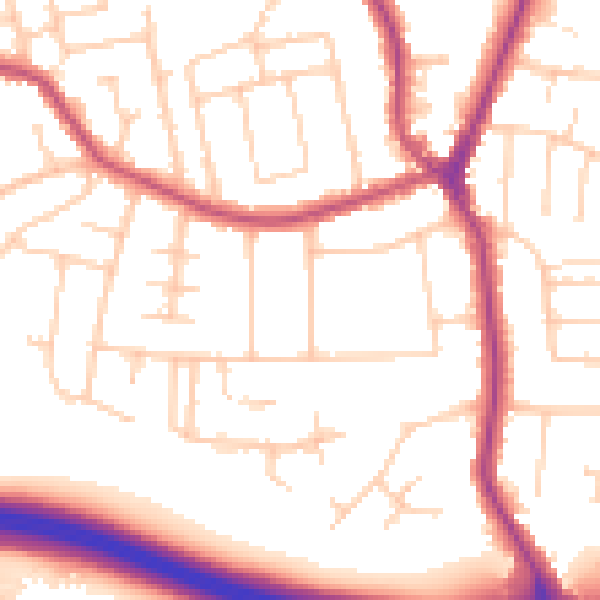
Daytime· 07:00 – 23:00
53.3dB

Night-time· 23:00 – 07:00
44.0dB