13 Ashbourne Drive, High Lane, Stockport, SK6 8DB
About 13 Ashbourne Drive
13 Ashbourne Drive is a two-bedroom property in High Lane, Stockport, Stockport (SK6 8DB). It has council tax band D.
Held since September 2007 — that's 19 years off the open market, well above the local norm. That sale landed at the peak of the pre-credit-crunch market, which is a useful reference point when interpreting the price. One planning record on file: an extension approved in 2002. Past consents include an extension and a conservatory, meaningful when judging how the property has evolved. Across 1999–2007, sale prices on this property compounded at 10.7% per year.
What this property has
Inside
- Bedrooms2
Everything you need to know about 13 Ashbourne Drive
The true value, the hidden risks and the full sale history, in one report.
Pick your report · every report is £14.99
One time fee only - money back guarantee

The data behind every report


Energy performance
No EPC on record
This property doesn't have an Energy Performance Certificate yet. An EPC is required to sell or let — and unlocks our automated valuation.
Get a survey for this property
Level 2 HomeBuyer Report
We've checked 10 risk factors against the available data for this property and believe a Level 2 HomeBuyer Report could be a suitable option for you.
Planning history
13 Ashbourne Drive has an approved rear extension on the planning record.
1 application on record at 13 Ashbourne Drive, High Lane, Stockport, SK6 8DB
- Apr 2002ConservatoryFullOutcome in report
Extension: Rear of property
Erection of conservatory to rear
Extension- Reference
- DC/007095
Unlock 13 Ashbourne Drive, High Lane, Stockport, SK6 8DB's full planning history
You're seeing the shape of it. The report has the substance.
- Every decision — granted, refused or withdrawn (1 on record)
- All 1 application on this property in full
- What the pattern means for extending or converting here
One time fee only - money back guarantee
Sales history & valuation
Sale price has at least doubled since 1999.
£268,000
Growth on file: 10.7% per year over 8 years.
Sales timeline
19 September 2007Most recent
£268,000
+127.1%over 8 years12 August 1999
£118,000
Median price across the last 5 sales in SK6 8DB: £420,000 (2024–2021).
Nearby sales in SK6 8DB
26 Ashbourne Drive, High Lane, Stockport, SK6 8DB
Sold Dec 2024
£500,00030 Ashbourne Drive, High Lane, Stockport, SK6 8DB
Sold Oct 2022
£420,00020 Ashbourne Drive, High Lane, Stockport, SK6 8DB
Sold Jan 2022
£437,00011 Ashbourne Drive, High Lane, Stockport, SK6 8DB
Sold Sept 2021
£400,00023 Ashbourne Drive, High Lane, Stockport, SK6 8DB
Sold Mar 2021
£350,000
Everything you need to know about 13 Ashbourne Drive
The true value, the hidden risks and the full sale history, in one report.
Pick your report · every report is £14.99
One time fee only - money back guarantee
The data behind every report
Similar properties nearby
1 Eden Avenue, High Lane
SK6 8BL
1 Andrew Lane, High Lane
SK6 8HT
1 Bramway, High Lane
SK6 8EN
1 Canal Mews, High Lane
SK6 8DP
1 Bowfell Drive, High Lane
SK6 8HZ
1 Dene Way, High Lane
SK6 8EQ
1 Brookside Lane, High Lane
SK6 8HL
1 Ashley Gardens, Windlehurst Road, High Lane
SK6 8AB
The neighbourhood at a glance
Rail-style transport is unusually close for this postcode.
Crime
1/mo
Steady year-on-year across the wider district.
Nearest stop
0.4 km
Hartington Road — bus stop.
Closest school
0.1 km
Brookside Primary School. 5 schools nearby.
Go deeper on the local area
A Local Area report breaks down crime, transport links, schools and air quality in depth.
Road noise across the postcode
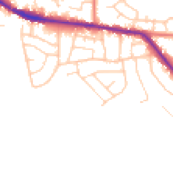
Daytime· 07:00 – 23:00
46.8dB

Night-time· 23:00 – 07:00
39.6dB