The Woodlands, Knutsford Road, Chelford, Macclesfield, SK11 9AS
About The Woodlands
The Woodlands is a five-bedroom detached house in Chelford, Macclesfield, Macclesfield (SK11 9AS). It has a recorded floor area of 613 m² (around 6598 sq ft), construction records dating it to 1900-1929 and council tax band H. The latest certificate (January 2026) shows an E (score 53), well below the UK norm with real room to improve. When first surveyed in March 2011 the rating was F, the property has climbed 1 band since. Between certificates, wall efficiency went from Very Poor to Poor, roof efficiency went from Very Poor to Good and lighting went from Very Poor to Good; while window efficiency dropped from Good to Poor. The recommended improvements would push it to D (score 66). Main heating runs on oil. This certificate was lodged in the last six months, so the rating reflects current condition.
Across 2000–2022, sale prices on this property compounded at 7.5% per year. Today's modelled estimate of £1,973,000 is 45.9% below the 2022 sale of £3,650,000, an unusual pattern given regional price growth and worth checking against the EPC condition. On a £-per-square-foot basis, the last sale (£553/sq ft) was about 173.4% above the typical sold price in the postcode. At 613 m² the property is well over the postcode median (113 m² across 12 EPCs), placing it in the larger end of the local stock. 5 bedrooms is on the larger side for this postcode, where 3 is the typical count. 4 planning records sit against the property, 3 approved, 1 refused. Past consents include an extension, meaningful when judging how the property has evolved. Most recent transfer: June 2022 at £3,650,000. That sale was during the post-pandemic price surge, when transactions cleared materially above pre-2020 trend.
What this property has
Inside
- Bedrooms5
- Bathrooms3
Everything you need to know about The Woodlands
The true value, the hidden risks and the full sale history, in one report.
30-day money-back guarantee

The data behind every report


Energy performance
The Woodlands's carbon output runs well above what efficient homes in the postcode produce.
EPC Rating
Property Improvements
Changes detected from historical EPC data
Heating controls changed
Cavity wall insulation installed
Roof insulation improved
Heating controls upgraded for better temperature management
More low energy lighting installed
Planning history
- Jul 2006Demolition And RebuildFullIn report
DEMOLITION OF EXISTING TWO STOREY BUILDING, ERECTION OF TWO STOREY BUILDING AND SINGLE STOREY LINK TO FORM GARAGE, SWIMMING POOL AND ANCILLARY ACCOMMODATION AMENDMENTS TO APPROVAL NO: 05/3046P
- Documents
- 13 docs on file
- Reference
- 06/1186P
- Feb 2006FullIn report
DEMOLITION OF EXISTING TWO STOREY BUILDING, ERECTION OF TWO STOREY BUILDING AND SINGLE STOREY LINK TO FORM GARAGE, SWIMMING POOL AND ANCILLARY ACCOMMODATION (RESUBMISSION OF 04/2041P)
- Documents
- 14 docs on file
- Reference
- 05/3046P
We flagged 1 thing worth checking at The Woodlands
Independent checks surfaced things a buyer would want to understand before offering. The report explains each one in full, with the underlying data and what to ask.
- Larger development activity nearby
30-day money-back guarantee
Sales history & valuation
Latest sale on The Woodlands was the highest on Land Registry record across the postcode.
£1,973,000
Modelled from EPC, postcode comparables and a sale-price growth of 7.5% per year over 22 years.
£3,650,000
Growth on file: 7.5% per year over 22 years.
Sales timeline
29 June 2022Most recent
£3,650,000
+400.0%over 22 years24 March 2000
£730,000
Median price across the last 5 sales in SK11 9AS: £380,000 (2024–2020).
Nearby sales in SK11 9AS
Cruachan, Knutsford Road, Chelford, Macclesfield, SK11 9AS
Sold Nov 2024
£260,0002 Knutsford Road Cottages, Knutsford Road, Chelford, Macclesfield, SK11 9AS
Sold Jun 2021
£320,000Candlewick Cottage, Knutsford Road, Chelford, Macclesfield, SK11 9AS
Sold Oct 2020
£433,000Oakleigh, Knutsford Road, Chelford, Macclesfield, SK11 9AS
Sold Mar 2020
£510,000Oak Cottage, Knutsford Road, Chelford, Macclesfield, SK11 9AS
Sold Feb 2020
£380,000
Versus other Knutsford Road homes
On price per m², The Woodlands stands well clear of the street.
Price per m²
£5,954
Street avg £2,119
Floor Area
613 m²
Street avg 133 m²
Habitable Rooms
10 rooms
Street avg 5 rooms
CO₂ Emissions
28.0 t/year
Street avg 6.7 t/year
Everything you need to know about The Woodlands
The true value, the hidden risks and the full sale history, in one report.
30-day money-back guarantee
The data behind every report
Similar properties nearby
1 Drumble Field, Chelford
SK11 9BT
1 Forge Close, Gawsworth
SK11 9EW
1 Burnt Acre, Chelford
SK11 9SS
1 2 Piggotts Hall, Congleton Lane, Lower Withington
SK11 9LD
1 Chapel Croft, Chelford
SK11 9SU
1 Edgeway, Henbury
SK11 9PA
1 Galloway Road, Chelford
SK11 9FX
1 Brookhouse Barn, Congleton Road, Gawsworth
SK11 9ET
The neighbourhood at a glance
Rail-style transport is unusually close for this postcode.
Crime
6/mo
Steady year-on-year across the wider district.
Nearest stop
0.0 km
Dixon Drive — bus stop.
Closest school
0.2 km
Chelford CofE Primary School. 2 schools nearby.
Go deeper on the local area
The full report breaks down crime, transport links, schools and air quality in depth.
Road noise across the postcode
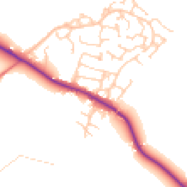
Daytime· 07:00 – 23:00
50.0dB

Night-time· 23:00 – 07:00
42.6dB