3 Balaclava Road, Southwark, London, SE1 5PX
About 3 Balaclava Road
3 Balaclava Road is a property in Southwark, London, London (SE1 5PX). It has council tax band D.
Energy performance
No EPC on record
This property doesn't have an Energy Performance Certificate yet. An EPC is required to sell or let — and unlocks our automated valuation.
Get a survey for this property
Level 2 HomeBuyer Report
We've checked 10 risk factors against the available data for this property and believe a Level 2 HomeBuyer Report could be a suitable option for you.
Planning history
No planning applications are recorded against 3 Balaclava Road, Southwark, London, SE1 5PX. The full report also covers planning activity across the surrounding area.
Sales history & valuation
No sales recorded with HM Land Registry
That can mean the property has never traded since the registry began publishing in 1995, was a new build that hasn't been registered yet, or is held in the same hands long-term.
Median price across the last 5 sales in SE1 5PX: £435,000 (2017–2013).
Nearby sales in SE1 5PX
37 Balaclava Road, Southwark, London, SE1 5PX
Sold Sept 2017
£75,0001 Balaclava Road, Southwark, London, SE1 5PX
Sold Jan 2017
£640,00023 Balaclava Road, Southwark, London, SE1 5PX
Sold May 2013
£488,50019 Balaclava Road, Southwark, London, SE1 5PX
Sold Feb 2013
£435,00021 Balaclava Road, Southwark, London, SE1 5PX
Sold Apr 2012
£450,000
Similar properties nearby
1 Abercorn Way, Southwark
SE1 5HL
1 Abingdon Close, Southwark
SE1 5RW
1 Acanthus Drive, Southwark
SE1 5HH
1 Achilles Close, Southwark
SE1 5HE
1 Ainsdale Drive, Southwark
SE1 5JY
1 Alma Grove, Southwark
SE1 5PY
1 Avocet Close, Southwark
SE1 5EN
1 Balaclava Road, Southwark
SE1 5PX
The neighbourhood at a glance
Reported crime in the wider district is trending notably upward year-on-year.
Crime
44/mo
Rising year-on-year across the wider district.
Nearest stop
0.1 km
Harris Academy — bus stop.
Closest school
0.2 km
Harris Academy Bermondsey. 101 schools nearby.
Road noise across the postcode
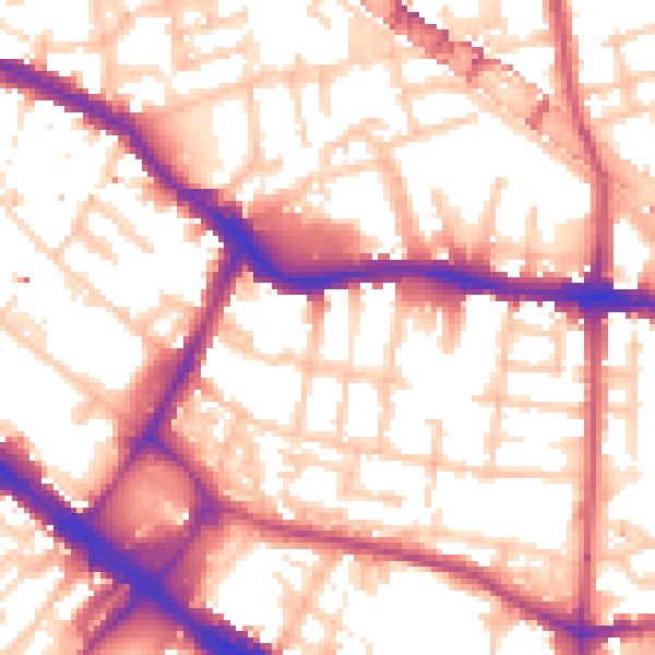
Daytime· 07:00 – 23:00
56.5dB

Night-time· 23:00 – 07:00
45.2dB