56 High Street, Clowne, Chesterfield, S43 4JU
About 56 High Street
56 High Street is a semi-detached house in Clowne, Chesterfield, Chesterfield (S43 4JU). It has a recorded floor area of 36 m² (around 388 sq ft), construction records dating it to 1930-1949 and council tax band A. The latest certificate (October 2022) shows a C (score 69), just inside the C band. The rating has held steady at C across 2 certificates since September 2012. Between certificates, wall efficiency dropped from Very Good to Poor and window efficiency dropped from Very Good to Good. At 36 m² this is the 2nd smallest of 38 units on EPC record in the building, where floor areas span 34–366 m². The building's EPC ratings span E to B across 38 units on file.
Today's modelled estimate of £116,000 is 34.8% below the 2016 sale of £178,000, running counter to the wider postcode trend, which makes the EPC and condition history especially worth a look. On a £-per-square-foot basis, the last sale (£459/sq ft) was about 341.3% above the typical sold price in the postcode. 4 planning records sit against the property, 1 approved, 2 refused. Past consents include partial demolition and change of use to residential, meaningful when judging how the property has evolved. 10 years since the last transfer (March 2016). At 36 m² it's 29.4% smaller than the typical home in the postcode (51 m² median across 37 EPCs).
Everything you need to know about 56 High Street
The true value, the hidden risks and the full sale history, in one report.
Pick your report · from £14.99
One time fee only - money back guarantee

The data behind every report


Energy performance
EPC Rating
Certificate validity
Valid until 17 October 2032
Property Improvements
Changes detected from historical EPC data
More low energy lighting installed

Get a survey for this property
Level 2 HomeBuyer Report
We've checked 10 risk factors against the available data for this property and believe a Level 2 HomeBuyer Report could be a suitable option for you.
From £495 · Includes VAT
Planning history
Planning history includes recorded demolition works, indicating a major rebuild phase at this address.
4 applications on record at 56 High Street, Clowne, Chesterfield, S43 4JU
- Jul 2008Change Of UseFullOutcome in report
Change use from retail to a licensed snooker club
- Documents
- 67 docs on file
- Reference
- 08/00100/FUL
- More recent applications — locked
- Change of UseJan 2011Decision
- Change of UseSept 2010Decision
+ 1 more application in the report
Unlock 56 High Street, Clowne, Chesterfield, S43 4JU's full planning history
You're seeing the shape of it. The report has the substance.
- Every decision — granted, refused or withdrawn (4 on record)
- All 4 applications on this property in full, plus 1 notable nearby
- The 125 documents, officer reports & conditions
- What the pattern means for extending or converting here
One time fee only - money back guarantee
Sales history & valuation
£116,000
Modelled from EPC, postcode comparables.
£178,000
Recorded with HM Land Registry.
Sales timeline
24 March 2016Most recent
£178,000
Median price across the last 5 sales in S43 4JU: £134,000 (2022–2018).
Nearby sales in S43 4JU
20 High Street, Clowne, Chesterfield, S43 4JU
Sold Jan 2022
£220,00042 High Street, Clowne, Chesterfield, S43 4JU
Sold Feb 2019
£134,00022a, High Street, Clowne, Chesterfield, S43 4JU
Sold Oct 2018
£110,00080 High Street, Clowne, Chesterfield, S43 4JU
Sold Jan 2018
£285,00048 High Street, Clowne, Chesterfield, S43 4JU
Sold Oct 2016
£170,000
Versus other High Street homes
56 High Street outperforms the street on price per m² by a wide margin.
Price per m²
£4,944
Street avg £939
Floor Area
36 m²
Street avg 48 m²
Habitable Rooms
2 rooms
Street avg 3 rooms
CO₂ Emissions
1.9 t/year
Street avg 1.2 t/year
Everything you need to know about 56 High Street
The true value, the hidden risks and the full sale history, in one report.
Pick your report · from £14.99
One time fee only - money back guarantee
The data behind every report
Similar properties nearby
1 Candlins Yard, High Street, Clowne
S43 4JU
1 California Lane, Barlborough
S43 4EZ
1 Ashlea Walk, Clowne
S43 4NR
1 Ashleigh Road, Barlborough
S43 4HU
1 Chestnut Drive, Clowne
S43 4JG
1 Blackberry Court, Clowne
S43 4QH
1 Cherry Tree Close, Clowne
S43 4BB
1 Chapel Close, Clowne
S43 4PB
The neighbourhood at a glance
Crime
212/mo
Steady year-on-year across the wider district.
Nearest stop
0.1 km
Miners Welfare — bus stop.
Closest school
0.3 km
Clowne Infant and Nursery School. 4 schools nearby.
Go deeper on the local area
A Local Area report breaks down crime, transport links, schools and air quality in depth.
Road noise across the postcode
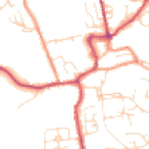
Daytime· 07:00 – 23:00
50.0dB

Night-time· 23:00 – 07:00
40.1dB