3 Hodges Court, Oxford, OX1 4NX
About 3 Hodges Court
3 Hodges Court is a one-bedroom semi-detached house in Oxford (OX1 4NX). It has a recorded floor area of 42 m² (around 452 sq ft), construction records dating it to 1991-1995 and council tax band D. At 42 m² this is the 4th smallest of 15 units on EPC record in the building, where floor areas span 34–72 m². The building's EPC ratings span E to B across 15 units on file. The latest certificate (March 2018) shows a C (score 72). Main heating runs on electricity.
Across 1995–2018, sale prices on this property compounded at 6.1% per year. On a £-per-square-foot basis, the last sale (£614/sq ft) was about 119.3% above the typical sold price in the postcode. At 42 m² it's 15.2% smaller than the typical home in the postcode (50 m² median across 14 EPCs). Sold July 2018 for £277,500.
What this property has
Inside
- Bedrooms1
- Bathrooms1
Everything you need to know about 3 Hodges Court
The true value, the hidden risks and the full sale history, in one report.
30-day money-back guarantee

The data behind every report


Energy performance
EPC Rating
Planning history
3 Hodges Court has no planning applications on record.
Notable planning nearby
21applications of note in the surrounding area
We flagged 2 things worth checking at 3 Hodges Court
Independent checks surfaced things a buyer would want to understand before offering. The report explains each one in full, with the underlying data and what to ask.
- Signs of HMO activity in the area
- Larger development activity nearby
30-day money-back guarantee
Sales history & valuation
Sale price has grown by over 3x since 1995.
£279,000
Modelled from EPC, postcode comparables and a sale-price growth of 6.1% per year over 23 years.
£277,500
Growth on file: 6.1% per year over 23 years.
Sales timeline
19 July 2018Most recent
£277,500
+291.1%over 23 years29 May 1995
£70,950
Median price across the last 5 sales in OX1 4NX: £360,000 (2025–2022).
Versus other Hodges Court homes
On floor area, 3 Hodges Court runs well behind the street norm.
Price per m²
£6,607
Street avg £4,701
Floor Area
42 m²
Street avg 50 m²
Habitable Rooms
2 rooms
Street avg 3 rooms
CO₂ Emissions
2.8 t/year
Street avg 2.9 t/year
Everything you need to know about 3 Hodges Court
The true value, the hidden risks and the full sale history, in one report.
30-day money-back guarantee
The data behind every report
Similar properties nearby
The neighbourhood at a glance
Reported crime in the wider district is trending notably upward year-on-year.
Crime
6/mo
Rising year-on-year across the wider district.
Nearest stop
0.1 km
Whitehouse Road — bus stop.
Closest school
0.3 km
St Ebbe's Church of England Aided Primary School. 18 schools nearby.
Go deeper on the local area
The full report breaks down crime, transport links, schools and air quality in depth.
Road noise across the postcode
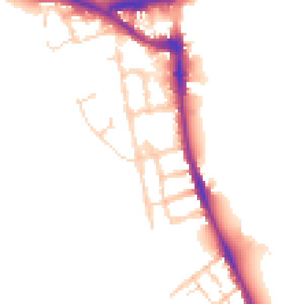
Daytime· 07:00 – 23:00
50.1dB

Night-time· 23:00 – 07:00
43.0dB