Are you a property professional?Get qualified leads from motivated homeowners.
Get started45 Cumbrian Gardens, Barnet, London, NW2 1ED
Extendable
About 45 Cumbrian Gardens
A plain-English summary derived from public records, EPC certificates, sold prices and local data.
45 Cumbrian Gardens is a three-bedroom semi-detached house in Barnet, London, London (NW2 1ED). It has a recorded floor area of 80 m² (around 861 sq ft), construction records dating it to 1950-1966 and council tax band E. The latest certificate (October 2017) shows an E (score 41), well below the UK norm with real room to improve. The recommended improvements would lift it to B (score 87), a 3-band jump. Our model identifies extension potential, subject to local planning policy.
On energy efficiency it sits in the bottom 10% of properties in this postcode — significant headroom for improvement. 3 planning records sit against the property, 2 approved, 0 refused. Past consents include subdivision, an extension and a porch, meaningful when judging how the property has evolved. Today's modelled estimate of £743,000 is 25.7% above the 2018 sale price. On a £-per-square-foot basis, the last sale (£686/sq ft) was about 77.7% above the typical sold price in the postcode. 8 years since the last transfer (January 2018).
What this property has
Pulled from EPC certificates, claim submissions and our property model. Empty categories are hidden — we only show what's known.
Inside
- Bedrooms3
- Dining roomYes
Outside
- Private gardenrear
Building
Energy performance
Every EPC certificate filed against this property — current rating, recorded improvements, and where there's headroom to reach a higher band.
45 Cumbrian Gardens sits at the bottom of the postcode for energy efficiency — meaningful headroom to improve.
EPC Rating
A
B
C
D
E
E41
F
G
Main Heating
Gas
Main Fuel
Gas
Hot Water
Average
Windows
Very Poor
CO2 Emissions
6.1 t/year
Occupancy
Owner Occupied
Planning history
Applications and permits filed against 45 Cumbrian Gardens, Barnet, London, NW2 1ED, sourced from the PlanIt planning register.
Council records show a subdivision application — the property's legal arrangement has been altered.
- Apr 2019SubdivisionFullApprove subject to conditions
Conversion of existing dwelling into 2no self-contained flats
Sales history & valuation
Recorded transactions, our model's current estimate, and a quick read on what neighbouring properties have sold for.
45 Cumbrian Gardens valuation sits well clear of the typical sold price in this postcode.
Current estimate
See how we calculated this£743,000
Modelled from EPC, postcode comparables.
Last sold (2018)
£591,000
Recorded with HM Land Registry.
Sales timeline
Versus other Cumbrian Gardens homes
Four headline reads against 10 similar houses on this street, drawn from the latest EPC and Land Registry data.
45 Cumbrian Gardens is notably below the street on epc rating.
Price per m²
£7,388
Street avg £5,819
Floor Area
80 m²
Street avg 97 m²
Habitable Rooms
5 rooms
Similar properties nearby
A handful of close matches in the same postcode area, ranked by likeness on bedrooms, type and floor area.
The neighbourhood at a glance
A condensed read of the local area. Each tile links through to the full breakdown on the London district page.
Rail-style transport is unusually close for this postcode.
Crime
14/mo
Rising year-on-year across the wider district.
Nearest stop
0.1 km
Cleveland Gardens — bus stop.
Road noise across the postcode
Modelled day and night-time noise levels around NW2 1ED from Defra's strategic mapping. The pin marks this postcode's centroid.
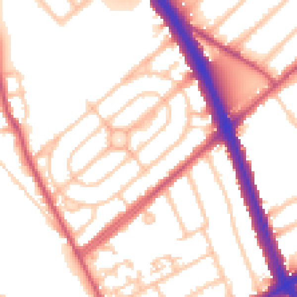
Daytime· 07:00 – 23:00
54.4dB

Everything within walking distance
Schools, transport stops and scenic spots near this property — 79 points of interest in total.
Beautiful places to visit nearby
Curated scenic spots within reach of this postcode, served by Beautifulplaces.ai. Photography and tagging come from their open dataset.
Common questions
The questions buyers, sellers and homeowners most often ask about 45 Cumbrian Gardens, Barnet, London, NW2 1ED. Each answer is also embedded as structured data for search engines.