19a, Beech Road, London, N11 2DA
About 19a
19a is a mid-terrace house in London (N11 2DA). It has a recorded floor area of 58 m² (around 624 sq ft), construction records dating it to 1900-1929 and council tax band C. At 58 m² this is the 5th smallest of 26 units on EPC record in the building, where floor areas span 51–94 m². The building's EPC ratings span E to C, with this unit at the top. The latest certificate (December 2024) shows a C (score 71).
It hasn't traded since September 1999, a hold of 27 years that's notably long for the area. On energy efficiency it sits in the top 10% of properties in this postcode. Across 1997–1999, sale prices on this property compounded at 36.7% per year. Today's modelled estimate of £332,000 sits 201.8% above the 1999 sale of £110,000. On a £-per-square-foot basis, the last sale (£176/sq ft) was about 27.9% below the postcode norm. One planning record on file: new windows approved in 2026. Past consents include new windows, meaningful when judging how the property has evolved.
Everything you need to know about 19a
The true value, the hidden risks and the full sale history, in one report.
30-day money-back guarantee

The data behind every report


Energy performance
19a ranks among the most efficient homes in the postcode for energy use.
EPC Rating
Planning history
- Mar 2026RenovationFullIn report
Replacement of existing door and windows to rear at ground floor level.
- Agent
- Crafted Architecture and Planning Ltd
New Windows- Documents
- 8 docs on file
- Reference
- 26/00174/FUL
We flagged 2 things worth checking at 19a
Independent checks surfaced things a buyer would want to understand before offering. The report explains each one in full, with the underlying data and what to ask.
- Signs of HMO activity in the area
- Larger development activity nearby
30-day money-back guarantee
Sales history & valuation
19a's modelled value sits at over four times its earliest registered sale price (1997).
£332,000
Modelled from EPC, postcode comparables and a sale-price growth of 36.7% per year over 2 years.
£110,000
Growth on file: 36.7% per year over 2 years.
Sales timeline
7 September 1999Most recent
£110,000
+89.7%over 2 years21 August 1997
£58,000
Median price across the last 5 sales in N11 2DA: £400,000 (2025–2022).
Nearby sales in N11 2DA
Versus other Beech Road homes
19a outperforms the street on epc rating by a wide margin.
Price per m²
£1,897
Street avg £3,197
Floor Area
58 m²
Street avg 64 m²
Habitable Rooms
3 rooms
Street avg 3 rooms
CO₂ Emissions
2.0 t/year
Street avg 3.0 t/year
Everything you need to know about 19a
The true value, the hidden risks and the full sale history, in one report.
30-day money-back guarantee
The data behind every report
Similar properties nearby
1 Maidstone Court, Maidstone Road, Enfield
N11 2TT
1 Beech Road, Enfield
N11 2DA
1 Park Grove, Haringey
N11 2QD
1 Maya Place, Haringey
N11 2EZ
1 Maidstone Road, Haringey
N11 2TR
1 Bexhill Road, Enfield
N11 2RG
1 Bailey Close, Haringey
N11 2JL
1 Evesham Road, Enfield
N11 2RR
The neighbourhood at a glance
Rail-style transport is unusually close for this postcode.
Crime
5/mo
Rising year-on-year across the wider district.
Nearest stop
0.2 km
York Road (N11) — bus stop.
Closest school
0.5 km
Bounds Green Junior School. 59 schools nearby.
Go deeper on the local area
The full report breaks down crime, transport links, schools and air quality in depth.
Road noise across the postcode
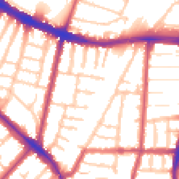
Daytime· 07:00 – 23:00
54.6dB

Night-time· 23:00 – 07:00
44.6dB