9 Heron Street, Manchester, M15 5PR
About 9 Heron Street
9 Heron Street is a three-bedroom detached house in Manchester (M15 5PR). It has a recorded floor area of 58 m² (around 624 sq ft), construction records dating it to 1996-2002 and council tax band A. At 58 m² this is the 14th smallest of 24 units on EPC record in the building, where floor areas span 26–70 m². The building's EPC ratings span D to B across 24 units on file. The latest certificate (June 2018) shows a C (score 75), near the top of the C band. Main heating runs on electricity.
Across 1999–2022, sale prices on this property compounded at 5.8% per year. Today's modelled estimate of £175,000 is 16.7% above the 2022 sale price. On a £-per-square-foot basis, the last sale (£240/sq ft) was about 90.7% above the typical sold price in the postcode. Most recent transfer: February 2022 at £150,000. That sale was during the post-pandemic price surge, when transactions cleared materially above pre-2020 trend.
What this property has
Inside
- Bedrooms3
- Bathrooms1
Everything you need to know about 9 Heron Street
The true value, the hidden risks and the full sale history, in one report.
30-day money-back guarantee

The data behind every report


Energy performance
EPC Rating
Planning history
9 Heron Street has no planning applications on record.
The full report still covers planning activity across the surrounding area.
Sales history & valuation
Sale price has grown by over 3x since 1999.
£175,000
Modelled from EPC, postcode comparables and a sale-price growth of 5.8% per year over 23 years.
£150,000
Growth on file: 5.8% per year over 23 years.
Sales timeline
25 February 2022Most recent
£150,000
+257.6%over 22 years1 July 1999
£41,950
Median price across the last 5 sales in M15 5PR: £195,000 (2024–2021).
Nearby sales in M15 5PR
Versus other Heron Street homes
On years held, 9 Heron Street runs well behind the street norm.
Price per m²
£2,586
Street avg £1,986
Floor Area
58 m²
Street avg 37 m²
Habitable Rooms
3 rooms
Street avg 2 rooms
CO₂ Emissions
2.9 t/year
Street avg 2.0 t/year
Everything you need to know about 9 Heron Street
The true value, the hidden risks and the full sale history, in one report.
30-day money-back guarantee
The data behind every report
Similar properties nearby
1 Heron Street
M15 5PR
1 Dunham Street
M15 5FX
1 Ancroft Street
M15 5JW
1 Colin Murphy Road
M15 5RS
1 Betsham Street
M15 5JN
1 Dearden Street
M15 5LZ
1 Bold Street, Hulme
M15 5QR
1 Drayton Street
M15 5LL
The neighbourhood at a glance
Crime
1/mo
Steady year-on-year across the wider district.
Nearest stop
0.1 km
Old Birley Street — bus stop.
Closest school
0.2 km
Loreto College. 48 schools nearby.
Go deeper on the local area
The full report breaks down crime, transport links, schools and air quality in depth.
Road noise across the postcode
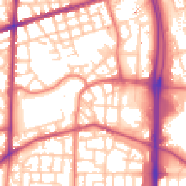
Daytime· 07:00 – 23:00
57.2dB

Night-time· 23:00 – 07:00
47.6dB