Flat 2, 104 Peel Road, Bootle, L20 4LA
About Flat 2
Flat 2 is a mid-terrace house in Bootle (L20 4LA). It has a recorded floor area of 65 m² (around 700 sq ft), construction records dating it to 1930-1949 and council tax band A. At 65 m² this is the largest unit on EPC record across the building (38–65 m²). The building's EPC ratings span F to C, with this unit at the top. On EPC score it ranks first in the building (77 versus a worst of 36). The latest certificate (September 2024) shows a C (score 77), near the top of the C band. The recommended improvements would push it to B (score 81).
Today's modelled estimate of £111,000 sits 122.2% above the 2017 sale of £49,950. Last changed hands 8 years ago, in December 2017. At 65 m² it's 17.7% smaller than the typical home in the postcode (79 m² median across 12 EPCs).
Everything you need to know about Flat 2
The true value, the hidden risks and the full sale history, in one report.
30-day money-back guarantee

The data behind every report


Energy performance
EPC Rating
Planning history
Flat 2 has no planning applications on record.
Notable planning nearby
4applications of note in the surrounding area
We flagged 1 thing worth checking at Flat 2
Independent checks surfaced things a buyer would want to understand before offering. The report explains each one in full, with the underlying data and what to ask.
- Larger development activity nearby
30-day money-back guarantee
Sales history & valuation
Flat 2 valuation sits well clear of the typical sold price in this postcode.
£111,000
Modelled from EPC, postcode comparables.
£49,950
Recorded with HM Land Registry.
Sales timeline
21 December 2017Most recent
£49,950
Median price across the last 5 sales in L20 4LA: £50,000 (2018–2017).
Versus other Peel Road homes
Price per m² for Flat 2 lags the street by a wide margin.
Price per m²
£768
Street avg £1,201
Floor Area
65 m²
Street avg 47 m²
Habitable Rooms
2 rooms
Street avg 2 rooms
CO₂ Emissions
1.7 t/year
Street avg 2.4 t/year
Everything you need to know about Flat 2
The true value, the hidden risks and the full sale history, in one report.
30-day money-back guarantee
The data behind every report
Similar properties nearby
91a, Flat 1, Knowsley Road
L20 4NH
Flat 1, 137 Balfour Road
L20 4NY
Flat 1, 155 Peel Road
L20 4JX
Flat 1, 27 Bank Road
L20 4AY
Flat 1, 11 Peel Road
L20 4RL
16a, Flat 3, Church Walk
L20 4DG
16a, Flat 1, Church Walk
L20 4DG
16a, Flat 5, Church Walk
L20 4DG
The neighbourhood at a glance
Rail-style transport is unusually close for this postcode.
Crime
7/mo
Rising year-on-year across the wider district.
Nearest stop
0.2 km
Tennyson Street — bus stop.
Closest school
0.4 km
Thomas Gray Primary School. 33 schools nearby.
Go deeper on the local area
The full report breaks down crime, transport links, schools and air quality in depth.
Road noise across the postcode
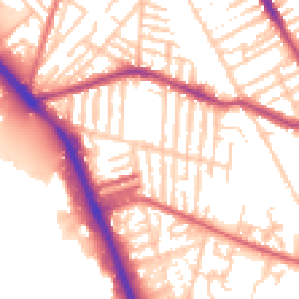
Daytime· 07:00 – 23:00
54.9dB

Night-time· 23:00 – 07:00
45.8dB