98 Greystone Road, Broadgreen, Liverpool, L14 6UH
About 98 Greystone Road
98 Greystone Road is a three-bedroom semi-detached house in Broadgreen, Liverpool, Liverpool (L14 6UH). It has a recorded floor area of 88 m² (around 947 sq ft), construction records dating it to 1930-1949 and council tax band B. The latest certificate (March 2014) shows an F (score 35), near the bottom of the EPC scale. The recommended improvements would lift it to C (score 80), a 3-band jump. The latest certificate is from March 2014, so improvements made since then won't be reflected. Records show the property has been extended at some point in its history.
Today's modelled estimate of £210,000 sits 72.8% above the 2014 sale of £121,500. On a £-per-square-foot basis, the last sale (£128/sq ft) was about 57.8% above the typical sold price in the postcode. It lags the bulk of the postcode on energy efficiency (less efficient than 83% of similar EPCs). On the market in October 2014 and unlisted since — roughly 12 years.
What this property has
Inside
- Bedrooms3
- Bathrooms1
Outside
- GarageYes
Building
- Central heatingYes
- Previously extendedYes
Everything you need to know about 98 Greystone Road
The true value, the hidden risks and the full sale history, in one report.
Pick your report · every report is £14.99
One time fee only - money back guarantee

The data behind every report


Energy performance
98 Greystone Road's carbon output runs well above what efficient homes in the postcode produce.
EPC Expired
This certificate is over 10 years old and is no longer valid.Expired 30 Mar 2024
EPC Rating
Get a survey for this property
Level 3 Building Survey
Because the property has solid (non-cavity) walls, we believe a Level 3 building survey should be considered.
From £885 · Includes VAT
Planning history
98 Greystone Road has no planning applications on record.
A planning report still maps activity across the surrounding area and reads this property's extension & conversion potential.
Sales history & valuation
98 Greystone Road valuation sits well clear of the typical sold price in this postcode.
£210,000
Modelled from EPC, postcode comparables.
£121,500
Recorded with HM Land Registry.
Sales timeline
27 October 2014Most recent
£121,500
Median price across the last 5 sales in L14 6UH: £114,950 (2021–2004).
Nearby sales in L14 6UH
90 Greystone Road, Broadgreen, Liverpool, L14 6UH
Sold Dec 2021
£153,00092 Greystone Road, Broadgreen, Liverpool, L14 6UH
Sold Apr 2011
£110,000108 Greystone Road, Broadgreen, Liverpool, L14 6UH
Sold Mar 2009
£70,00088 Greystone Road, Broadgreen, Liverpool, L14 6UH
Sold Aug 2008
£128,000120 Greystone Road, Broadgreen, Liverpool, L14 6UH
Sold Sept 2004
£114,950
Versus other Greystone Road homes
98 Greystone Road is notably below the street on habitable rooms.
Price per m²
£1,381
Street avg £1,116
Floor Area
88 m²
Street avg 99 m²
Habitable Rooms
4 rooms
Street avg 5 rooms
CO₂ Emissions
7.6 t/year
Street avg 5.0 t/year
Everything you need to know about 98 Greystone Road
The true value, the hidden risks and the full sale history, in one report.
Pick your report · every report is £14.99
One time fee only - money back guarantee
The data behind every report
Similar properties nearby
1 Ringwood Avenue
L14 6TH
1 Greystone Road, Broadgreen
L14 6UD
1 Norbreck Avenue
L14 6UN
10 Malvern Crescent
L14 6TP
1 Penrose Avenue West
L14 6UT
1 Westfield Avenue
L14 6UY
1 Penrose Avenue East
L14 6UU
1 Wyndham Avenue
L14 6TD
The neighbourhood at a glance
Rail-style transport is unusually close for this postcode.
Crime
6/mo
Rising year-on-year across the wider district.
Nearest stop
0.3 km
Ashfield Way — bus stop.
Closest school
0.2 km
Malvern Primary School. 47 schools nearby.
Go deeper on the local area
A Local Area report breaks down crime, transport links, schools and air quality in depth.
Road noise across the postcode
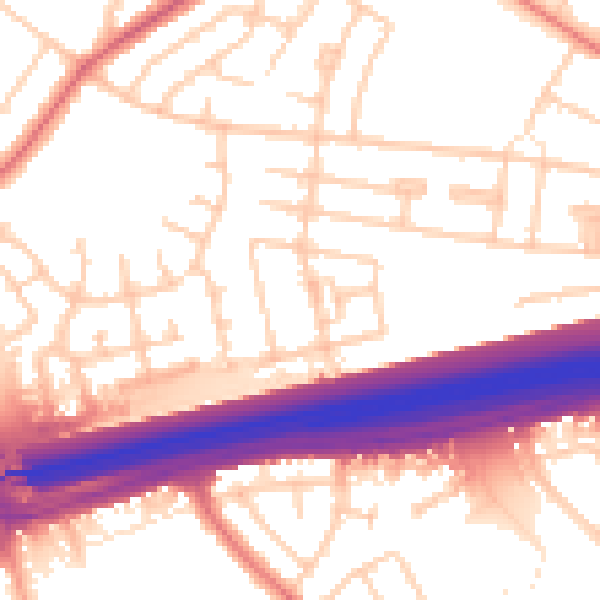
Daytime· 07:00 – 23:00
55.3dB

Night-time· 23:00 – 07:00
46.2dB