1 Penrose Avenue West, Liverpool, L14 6UT
About 1 Penrose Avenue West
1 Penrose Avenue West is a three-bedroom semi-detached house in Liverpool (L14 6UT). It has a recorded floor area of 90 m² (around 969 sq ft), construction records dating it to 1930-1949 and council tax band B. The latest certificate (March 2009) shows a C (score 73). The latest certificate is from March 2009, so improvements made since then won't be reflected.
Across 2003–2015, sale prices on this property compounded at 4.4% per year. Today's modelled estimate of £190,000 sits 59% above the 2015 sale of £119,500. On a £-per-square-foot basis, the last sale (£123/sq ft) was about 31.3% above the typical sold price in the postcode. One planning record on file: an extension approved in 2015. Past consents include an extension, meaningful when judging how the property has evolved. On the market in February 2015 and unlisted since — roughly 11 years.
What this property has
Inside
- Bedrooms3
Everything you need to know about 1 Penrose Avenue West
The true value, the hidden risks and the full sale history, in one report.
Pick your report · every report is £14.99
One time fee only - money back guarantee

The data behind every report


Energy performance
1 Penrose Avenue West's EPC is over a decade old — improvements since won't be reflected.
EPC Expired
This certificate is over 10 years old and is no longer valid.Expired 03 Mar 2019
EPC Rating
Get a survey for this property
Level 2 HomeBuyer Report
We've checked 10 risk factors against the available data for this property and believe a Level 2 HomeBuyer Report could be a suitable option for you.
From £495 · Includes VAT
Planning history
Council records include a two-storey side extension at 1 Penrose Avenue West.
1 application on record at 1 Penrose Avenue West, Liverpool, L14 6UT
- Jun 2015ExtensionFullOutcome in report
Extension: Two storey · Side of property
DEMOLITION OF EXISTING EXTERNAL DIVIDING WALL AND ERECTION OF TWO STOREY EXTENSION TO SIDE OF DWELLING
- Documents
- 5 docs on file
- Reference
- 15/00219/FUL
Unlock 1 Penrose Avenue West, Liverpool, L14 6UT's full planning history
You're seeing the shape of it. The report has the substance.
- Every decision — granted, refused or withdrawn (1 on record)
- All 1 application on this property in full
- The 5 documents, officer reports & conditions
- What the pattern means for extending or converting here
One time fee only - money back guarantee
Sales history & valuation
1 Penrose Avenue West valuation sits well clear of the typical sold price in this postcode.
£190,000
Modelled from EPC, postcode comparables and a sale-price growth of 4.4% per year over 12 years.
£119,500
Growth on file: 4.4% per year over 12 years.
Sales timeline
24 February 2015Most recent
£119,500
+66.0%over 11 years12 June 2003
£72,000
Median price across the last 5 sales in L14 6UT: £108,000 (2016–2007).
Nearby sales in L14 6UT
5 Penrose Avenue West, Liverpool, L14 6UT
Sold Apr 2016
£95,00017 Penrose Avenue West, Liverpool, L14 6UT
Sold Mar 2016
£108,00010 Penrose Avenue West, Liverpool, L14 6UT
Sold Aug 2012
£124,00014 Penrose Avenue West, Liverpool, L14 6UT
Sold Apr 2009
£120,00020 Penrose Avenue West, Liverpool, L14 6UT
Sold Nov 2006
£130,000
Versus other Penrose Avenue West homes
Price per m²
£1,328
Street avg £1,015
Floor Area
90 m²
Street avg 89 m²
Habitable Rooms
5 rooms
Street avg 5 rooms
CO₂ Emissions
3.2 t/year
Street avg 3.3 t/year
Everything you need to know about 1 Penrose Avenue West
The true value, the hidden risks and the full sale history, in one report.
Pick your report · every report is £14.99
One time fee only - money back guarantee
The data behind every report
Similar properties nearby
1 Westfield Avenue
L14 6UY
1 Penrose Avenue East
L14 6UU
1 Wyndham Avenue
L14 6TD
10 Malvern Crescent
L14 6TP
1 Greystone Road, Broadgreen
L14 6UD
1 Ringwood Avenue
L14 6TH
1 Norbreck Avenue
L14 6UN
10 Regent Avenue
L14 6UL
The neighbourhood at a glance
Rail-style transport is unusually close for this postcode.
Crime
6/mo
Rising year-on-year across the wider district.
Nearest stop
0.2 km
Grangewood — bus stop.
Closest school
0.2 km
Malvern Primary School. 47 schools nearby.
Go deeper on the local area
A Local Area report breaks down crime, transport links, schools and air quality in depth.
Road noise across the postcode
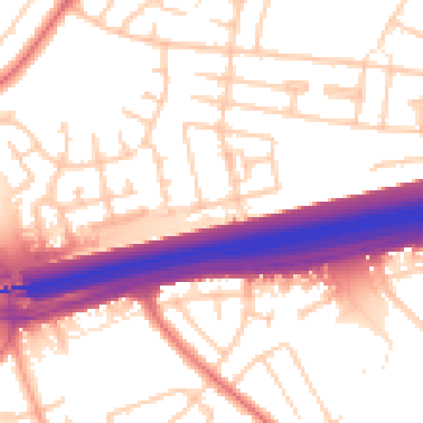
Daytime· 07:00 – 23:00
55.3dB

Night-time· 23:00 – 07:00
46.4dB