11 Ely Road, Ipswich, IP4 3BY
About 11 Ely Road
11 Ely Road is a three-bedroom semi-detached house in Ipswich (IP4 3BY). It has a recorded floor area of 87 m² (around 936 sq ft), construction records dating it to 1950-1966 and council tax band C. The latest certificate (April 2021) shows a D (score 61), on the cusp of jumping into the C band. When first surveyed in July 2010 the rating was E, the property has climbed 1 band since. Between certificates, roof efficiency went from Very Poor to Average, window efficiency went from Poor to Average and main heating went from Average to Good; while wall efficiency dropped from Good to Average and lighting dropped from Good to Average. The recommended improvements would lift it to B (score 85), a 2-band jump. The home occupies a cul-de-sac position.
Across 2000–2021, sale prices on this property compounded at 8.3% per year. On a £-per-square-foot basis, the last sale (£294/sq ft) was about 29.5% above the typical sold price in the postcode. Last sale on file: £275,000 in September 2021. That sale was during the post-pandemic price surge, when transactions cleared materially above pre-2020 trend.
What this property has
Inside
- Bedrooms3
- Bathrooms1
- Dining roomYes
Outside
- Private gardenYes
- Cul-de-sacYes
Everything you need to know about 11 Ely Road
The true value, the hidden risks and the full sale history, in one report.
Pick your report · every report is £14.99
One time fee only - money back guarantee

The data behind every report


Energy performance
Recommended upgrades on file would lift this property by multiple EPC bands.
EPC Rating
Property Improvements
Changes detected from historical EPC data
Windows upgraded, improving insulation
Low energy lighting percentage decreased
Get a survey for this property
Level 2 HomeBuyer Report
We've checked 10 risk factors against the available data for this property and believe a Level 2 HomeBuyer Report could be a suitable option for you.
From £545 · Includes VAT
Planning history
11 Ely Road has no planning applications on record.
But the area is active
2 notable applications nearby — larger schemes and conversions that could reshape the street. The report maps them all.
Sales history & valuation
Price for 11 Ely Road has grown more than fourfold since the 2000 starting point.
£297,000
Modelled from EPC, postcode comparables and a sale-price growth of 8.3% per year over 22 years.
£275,000
Growth on file: 8.3% per year over 22 years.
Sales timeline
22 September 2021Most recent
£275,000
+459.9%over 21 years18 February 2000
£49,118
Median price across the last 5 sales in IP4 3BY: £325,000 (2021–2017).
Versus other Ely Road homes
Years Held for 11 Ely Road lags the street by a wide margin.
Price per m²
£3,161
Street avg £2,813
Floor Area
87 m²
Street avg 100 m²
Habitable Rooms
5 rooms
Street avg 5 rooms
CO₂ Emissions
4.2 t/year
Street avg 4.2 t/year
Everything you need to know about 11 Ely Road
The true value, the hidden risks and the full sale history, in one report.
Pick your report · every report is £14.99
One time fee only - money back guarantee
The data behind every report
Similar properties nearby
The neighbourhood at a glance
Reported crime in the wider district is trending notably upward year-on-year.
Crime
9/mo
Rising year-on-year across the wider district.
Nearest stop
0.2 km
Baptist Church — bus stop.
Closest school
0.2 km
Northgate High School. 17 schools nearby.
Go deeper on the local area
A Local Area report breaks down crime, transport links, schools and air quality in depth.
Road noise across the postcode
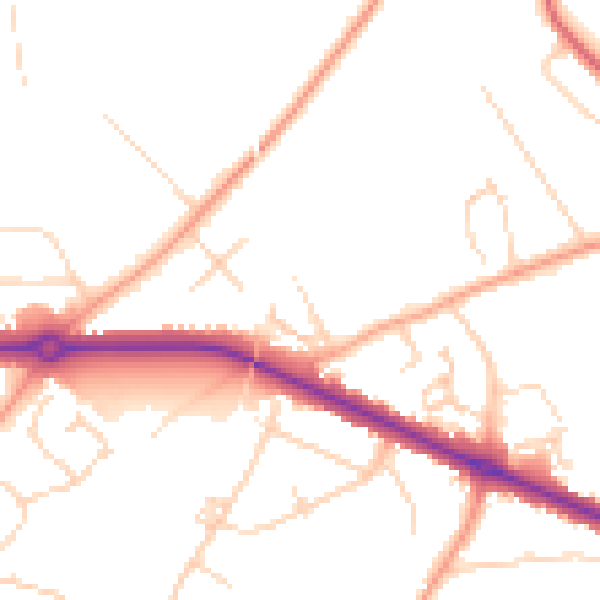
Daytime· 07:00 – 23:00
49.1dB

Night-time· 23:00 – 07:00
39.6dB