19a, Nibthwaite Road, Harrow, HA1 1TB
About 19a
19a is a semi-detached house in Harrow (HA1 1TB). It has a recorded floor area of 61 m² (around 657 sq ft), construction records dating it to 1930-1949 and council tax band C. The latest certificate (February 2025) shows a C (score 71).
It hasn't traded since April 2006, a hold of 20 years that's notably long for the area. At 61 m² it sits well below the postcode median (93 m² across 27 EPCs), making it one of the more compact homes locally. Today's modelled estimate of £435,000 is 45% above the 2006 sale price. On a £-per-square-foot basis, the last sale (£457/sq ft) was about 70.4% above the typical sold price in the postcode.
Know exactly what you're buying at 19a
Before you offer, see what the listing won't tell you, the true value, the red flags and the full history.
Already flagged here
Valuation
against the asking price
Risks
planning & flood
Sold prices
similar homes nearby
Trends
the local market
Energy performance
EPC Rating
Planning history
19a has no planning applications on record.
Notable planning nearby
9applications of note in the surrounding area
We flagged 1 thing worth checking at 19a
Independent checks surfaced things a buyer would want to understand before offering. The report explains each one in full, with the underlying data and what to ask.
- Signs of HMO activity in the area
30-day money-back guarantee
Sales history & valuation
19a valuation sits well clear of the typical sold price in this postcode.
£435,000
Modelled from EPC, postcode comparables.
£300,000
Recorded with HM Land Registry.
Sales timeline
27 April 2006Most recent
£300,000
Median price across the last 5 sales in HA1 1TB: £580,000 (2025–2022).
Nearby sales in HA1 1TB
Everything we know about 19a, in one report
What it's really worth, what could be wrong, and the planning, sales and area data in full.
What we flagged
- Signs of HMO activity in the area

Versus other Nibthwaite Road homes
19a outperforms the street on co₂ emissions by a wide margin.
Price per m²
£4,918
Street avg £3,960
Floor Area
61 m²
Street avg 76 m²
Habitable Rooms
3 rooms
Street avg 4 rooms
CO₂ Emissions
2.2 t/year
Street avg 3.2 t/year
Similar properties nearby
The neighbourhood at a glance
Rail-style transport is unusually close for this postcode.
Crime
28/mo
Steady year-on-year across the wider district.
Nearest stop
0.2 km
Safari Cinema — bus stop.
Closest school
0.3 km
Saint Jerome Church of England Bilingual School. 40 schools nearby.
Go deeper on the local area
The full report breaks down crime, transport links, schools and air quality in depth.
Road noise across the postcode
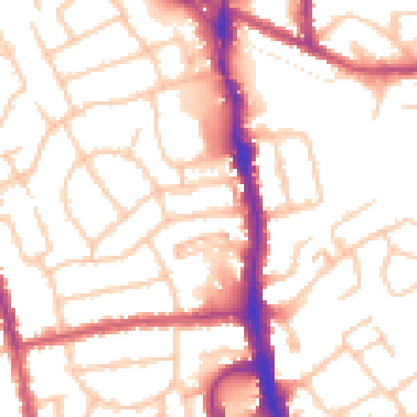
Daytime· 07:00 – 23:00
52.8dB

Night-time· 23:00 – 07:00
41.4dB