Rostherne, Springfield Road, Welling, DA16 1QN
About Rostherne
Rostherne is a semi-detached house in Welling (DA16 1QN). It has a recorded floor area of 89 m² (around 958 sq ft), construction records dating it to 1900-1929 and council tax band D. The latest certificate (January 2019) shows a D (score 58), a step below the typical UK home. When first surveyed in February 2009 the rating was E, the property has climbed 1 band since. Between certificates, hot-water efficiency went from Good to Very Good and lighting went from Average to Very Good. The recommended improvements would lift it to B (score 83), a 2-band jump.
One historical planning record sits against the property in 2026.
Know exactly what you're buying at Rostherne
Before you offer, see what the listing won't tell you, the true value, the red flags and the full history.
Already flagged here
Valuation
against the asking price
Risks
planning & flood
Sold prices
similar homes nearby
Trends
the local market
Energy performance
Recommended upgrades on file would lift this property by multiple EPC bands.
EPC Rating
Property Improvements
Changes detected from historical EPC data
Hot water efficiency improved
More low energy lighting installed
Planning history
- Mar 2026Loft ConversionFullIn report
Conversion of roof space including rear dormer extension and rooflights to front roof slope.
- Documents
- 11 docs on file
- Reference
- 26/00664/FUL
We flagged 1 thing worth checking at Rostherne
Independent checks surfaced things a buyer would want to understand before offering. The report explains each one in full, with the underlying data and what to ask.
- Larger development activity nearby
30-day money-back guarantee
Sales history & valuation
Rostherne has no Land Registry sales on file, suggesting it has stayed in the same hands since registration began.
£453,000
Modelled from EPC, postcode comparables.
No sales recorded with HM Land Registry
That can mean the property has never traded since the registry began publishing in 1995, was a new build that hasn't been registered yet, or is held in the same hands long-term.
Median price across the last 5 sales in DA16 1QN: £400,000 (2023–2018).
Nearby sales in DA16 1QN
31 Springfield Road, Welling, DA16 1QN
Sold May 2023
£385,00013 Springfield Road, Welling, DA16 1QN
Sold May 2023
£510,0001a, Springfield Road, Welling, DA16 1QN
Sold Jan 2021
£540,00021 Springfield Road, Welling, DA16 1QN
Sold Apr 2019
£400,000Kyrenia, Springfield Road, Welling, DA16 1QN
Sold Nov 2016
£270,000
Everything we know about Rostherne, in one report
What it's really worth, what could be wrong, and the planning, sales and area data in full.
What we flagged
- Larger development activity nearby

Versus other Springfield Road homes
EPC Rating for Rostherne lags the street by a wide margin.
EPC Rating
58 (D)
Street avg 60 (D)
Floor Area
89 m²
Street avg 100 m²
CO₂ Emissions
4.1 t/year
Street avg 4.6 t/year
Habitable Rooms
5 rooms
Street avg 5 rooms
Similar properties nearby
The neighbourhood at a glance
Rail-style transport is unusually close for this postcode.
Crime
6/mo
Steady year-on-year across the wider district.
Nearest stop
0.1 km
Springfield Road (DA16) — bus stop.
Closest school
0.4 km
St Stephen's Catholic Primary School. 42 schools nearby.
Go deeper on the local area
The full report breaks down crime, transport links, schools and air quality in depth.
Road noise across the postcode
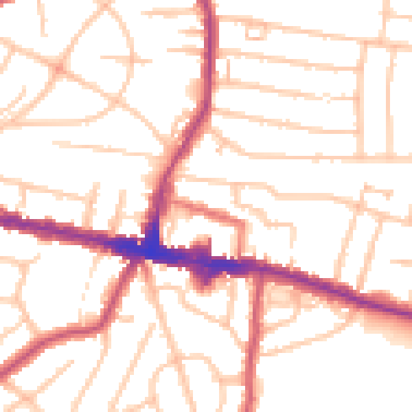
Daytime· 07:00 – 23:00
51.7dB

Night-time· 23:00 – 07:00
41.7dB