24 Colley Lane, Sandbach, CW11 4HE
About 24 Colley Lane
24 Colley Lane is a three-bedroom semi-detached house in Sandbach (CW11 4HE). It has a recorded floor area of 55 m² (around 592 sq ft), construction records dating it to before 1900 and council tax band C. The latest certificate (February 2016) shows an E (score 52), well below the UK norm with real room to improve. The rating has held steady at E across 2 certificates since December 2013. Between certificates, roof efficiency went from Very Poor to Very Good and lighting went from Very Poor to Poor; while window efficiency dropped from Good to Average. The recommended improvements would lift it to B (score 84), a 3-band jump. The latest certificate is from February 2016, so improvements made since then won't be reflected. Records show the property has been extended at some point in its history.
At 55 m² it sits well below the postcode median (96 m² across 21 EPCs), making it one of the more compact homes locally. On energy efficiency it sits in the bottom 10% of properties in this postcode — significant headroom for improvement. Across 2007–2016, sale prices on this property compounded at 2.1% per year. Today's modelled estimate of £282,000 is 44.6% above the 2016 sale price. On a £-per-square-foot basis, the last sale (£329/sq ft) was about 122.3% above the typical sold price in the postcode. Last sold in July 2016, so it's been off the market for around 10 years. One historical planning record sits against the property in 2009.
Know exactly what you're buying at 24 Colley Lane
Before you offer, see what the listing won't tell you, the true value, the red flags and the full history.
Already flagged here
Valuation
against the asking price
Risks
planning & flood
Sold prices
similar homes nearby
Trends
the local market
What this property has
Inside
- Bedrooms3
- Utility roomYes
- FireplaceYes
Outside
- Private gardenRear
- ParkingOff road
Building
- Previously extendedYes
Energy performance
24 Colley Lane sits at the bottom of the postcode for energy efficiency — meaningful headroom to improve.
EPC Expired
This certificate is over 10 years old and is no longer valid.Expired 01 Mar 2026
EPC Rating
Property Improvements
Changes detected from historical EPC data
Heating controls upgraded for better temperature management
Loft insulation installed or upgraded to 250mm+
More low energy lighting installed
Planning history
- Jun 2009New BuildFullIn report
Construction of detached dwelling and new vehicular access
- Documents
- 40 docs on file
- Reference
- 09/0423C
We flagged 1 thing worth checking at 24 Colley Lane
Independent checks surfaced things a buyer would want to understand before offering. The report explains each one in full, with the underlying data and what to ask.
- Larger development activity nearby
30-day money-back guarantee
Sales history & valuation
24 Colley Lane valuation sits well clear of the typical sold price in this postcode.
£282,000
Modelled from EPC, postcode comparables and a sale-price growth of 2.1% per year over 9 years.
£195,000
Growth on file: 2.1% per year over 9 years.
Sales timeline
12 July 2016Most recent
£195,000
+21.9%over 9 years6 February 2007
£160,000
Median price across the last 5 sales in CW11 4HE: £350,000 (2025–2021).
Everything we know about 24 Colley Lane, in one report
What it's really worth, what could be wrong, and the planning, sales and area data in full.
What we flagged
- Larger development activity nearby

Versus other Colley Lane homes
Price per m² for 24 Colley Lane runs comfortably ahead of the street norm.
Price per m²
£3,545
Street avg £2,369
Floor Area
55 m²
Street avg 105 m²
Habitable Rooms
5 rooms
Street avg 5 rooms
CO₂ Emissions
4.6 t/year
Street avg 4.2 t/year
Similar properties nearby
1 Coldmoss Drive
CW11 4HW
1 Charles Barnett Road, Winterley
CW11 4TT
1 Crown Drive, Malkins Bank
CW11 4AR
1 Betchton Heath Cottages, Reynolds Lane, Betchton
CW11 4SX
1 Charles Square, Hassall Green
CW11 4XZ
1 Brookside Cottages, Congleton Road, Arclid
CW11 4SN
1 Brook Mews, Flat Lane
CW11 4BD
1 Alsager Road, Winterley
CW11 4RG
The neighbourhood at a glance
Crime
3/mo
Steady year-on-year across the wider district.
Nearest stop
0.2 km
Top Of The Hill Chip Shop — bus stop.
Closest school
0.9 km
St John's CofE Academy. 8 schools nearby.
Go deeper on the local area
The full report breaks down crime, transport links, schools and air quality in depth.
Road noise across the postcode
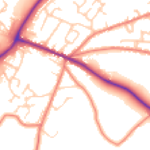
Daytime· 07:00 – 23:00
53.7dB

Night-time· 23:00 – 07:00
45.0dB