10 Cashmore Road, Kenilworth, CV8 2SJ
About 10 Cashmore Road
10 Cashmore Road is a three-bedroom detached house in Kenilworth (CV8 2SJ). It has a recorded floor area of 92 m² (around 990 sq ft), construction records dating it to 1983-1990 and council tax band E. The latest certificate (March 2021) shows a D (score 56), a step below the typical UK home. The recommended improvements would push it to C (score 76).
Sold August 2021 for £435,000. Across the public record there are 6 sales, relatively high churn for a single property. That sale was during the post-pandemic price surge, when transactions cleared materially above pre-2020 trend. Across 1998–2021, sale prices on this property compounded at 5.8% per year. Today's modelled estimate of £489,000 is 12.4% above the 2021 sale price. On a £-per-square-foot basis, the last sale (£439/sq ft) was about 38.6% above the typical sold price in the postcode.
Know exactly what you're buying at 10 Cashmore Road
Before you offer, see what the listing won't tell you, the true value, the red flags and the full history.
Already flagged here
Valuation
against the asking price
Risks
planning & flood
Sold prices
similar homes nearby
Trends
the local market
What this property has
Inside
- Bedrooms3
- Bathrooms1
- Dining roomYes
- Utility roomYes
- CloakroomYes
Outside
- Private gardenRear
- GarageYes
Building
- Central heatingYes
- RefurbishedYes
Energy performance
EPC Rating
Planning history
10 Cashmore Road has no planning applications on record.
Notable planning nearby
5applications of note in the surrounding area
We flagged 1 thing worth checking at 10 Cashmore Road
Independent checks surfaced things a buyer would want to understand before offering. The report explains each one in full, with the underlying data and what to ask.
- Larger development activity nearby
30-day money-back guarantee
Sales history & valuation
Sale price has grown by over 3x since 1998.
£489,000
Modelled from EPC, postcode comparables and a sale-price growth of 5.8% per year over 23 years.
£435,000
Growth on file: 5.8% per year over 23 years.
Sales timeline
12 August 2021Most recent
£435,000
+47.5%over 15 years3 May 2006
£295,000
+39.2%over 2 years1 December 2003
£212,000
+34.2%over 2 years26 July 2001
£158,000
+31.1%over 2 years29 July 1998
£120,500
+2.6%29 June 1998
£117,500
Median price across the last 5 sales in CV8 2SJ: £450,000 (2023–2021).
Nearby sales in CV8 2SJ
Everything we know about 10 Cashmore Road, in one report
What it's really worth, what could be wrong, and the planning, sales and area data in full.
What we flagged
- Larger development activity nearby

Versus other Cashmore Road homes
EPC Rating for 10 Cashmore Road lags the street by a wide margin.
Price per m²
£4,728
Street avg £4,133
Floor Area
92 m²
Street avg 92 m²
Habitable Rooms
6 rooms
Street avg 5 rooms
CO₂ Emissions
5.2 t/year
Street avg 3.9 t/year
Similar properties nearby
The neighbourhood at a glance
Crime
3/mo
Steady year-on-year across the wider district.
Nearest stop
0.2 km
Mayfield Drive — bus stop.
Closest school
0.5 km
Kenilworth School and Sixth Form. 7 schools nearby.
Go deeper on the local area
The full report breaks down crime, transport links, schools and air quality in depth.
Road noise across the postcode
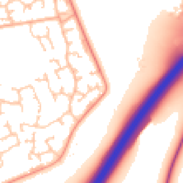
Daytime· 07:00 – 23:00
54.8dB

Night-time· 23:00 – 07:00
46.5dB