642 Galleywood Road, Chelmsford, CM2 8BY
About 642 Galleywood Road
642 Galleywood Road is a detached house in Chelmsford (CM2 8BY). It has a recorded floor area of 83 m² (around 893 sq ft), construction records dating it to 1930-1949 and council tax band D. The latest certificate (November 2018) shows a D (score 64), on the cusp of jumping into the C band. When first surveyed in October 2016 the rating was F, the property has climbed 2 bands since. Between certificates, roof efficiency went from Good to Very Good and hot-water efficiency went from Poor to Good. The recommended improvements would lift it to B (score 85), a 2-band jump.
Across 2017–2024, sale prices on this property compounded at 8.2% per year. Today's modelled estimate of £452,000 is 19.3% below the 2024 sale of £560,000, below the original sale price, which typically signals condition or completion-status changes worth verifying. On a £-per-square-foot basis, the last sale (£627/sq ft) was about 129% above the typical sold price in the postcode. At 83 m² it sits well below the postcode median (128 m² across 28 EPCs), making it one of the more compact homes locally. Sold April 2024 for £560,000. One historical planning record sits against the property in 2023.
Everything you need to know about 642 Galleywood Road
The true value, the hidden risks and the full sale history, in one report.
Pick your report · from £14.99
One time fee only - money back guarantee

The data behind every report







Energy performance
Recommended upgrades on file would lift this property by multiple EPC bands.
EPC Rating
Certificate validity
Valid until 2 November 2028
Property Improvements
Changes detected from historical EPC data
Heating controls upgraded for better temperature management
Hot water efficiency improved
Roof insulation improved
More low energy lighting installed

Get a survey for this property
Level 3 Building Survey
Because the property has solid (non-cavity) walls, we believe a Level 3 building survey should be considered.
From £1,020 · Includes VAT
Planning history
Planning history includes recorded demolition works, indicating a major rebuild phase at this address.
1 application on record at 642 Galleywood Road, Chelmsford, CM2 8BY
- Sept 2023DemolitionFullOutcome in report
Demolition of the existing buildings and the construction of a specialist 60 bedroom dementia care home (Use Class C2) together with modifications to the site access, associated car and cycle parking, structural landscaping and amenity space provision.
- Documents
- 67 docs on file
- Reference
- 22/02264/FUL
Unlock 642 Galleywood Road, Chelmsford, CM2 8BY's full planning history
You're seeing the shape of it. The report has the substance.
- Every decision — granted, refused or withdrawn
- All 1 application on this property in full, plus 1 notable nearby
- The 67 documents, officer reports & conditions
- What the pattern means for extending or converting here
One time fee only - money back guarantee
Sales history & valuation
642 Galleywood Road valuation sits well clear of the typical sold price in this postcode.
£452,000
Modelled from EPC, postcode comparables and a sale-price growth of 8.2% per year over 6 years.
£560,000
Growth on file: 8.2% per year over 6 years.
Sales timeline
7 April 2024Most recent
£560,000
+64.7%over 6 years8 December 2017
£340,000
Median price across the last 5 sales in CM2 8BY: £792,193 (2026–2024).
Nearby sales in CM2 8BY
654 Galleywood Road, Chelmsford, CM2 8BY
Sold Apr 2026
£792,193678 Galleywood Road, Chelmsford, CM2 8BY
Sold Oct 2025
£575,000650 Galleywood Road, Chelmsford, CM2 8BY
Sold Sept 2024
£900,000658 Galleywood Road, Chelmsford, CM2 8BY
Sold May 2024
£635,000640 Galleywood Road, Chelmsford, CM2 8BY
Sold Apr 2024
£2,410,000
Versus other Galleywood Road homes
Price per m² for 642 Galleywood Road runs comfortably ahead of the street norm.
Price per m²
£6,747
Street avg £4,975
Floor Area
83 m²
Street avg 134 m²
Habitable Rooms
4 rooms
Street avg 6 rooms
CO₂ Emissions
3.8 t/year
Street avg 6.2 t/year
Everything you need to know about 642 Galleywood Road
The true value, the hidden risks and the full sale history, in one report.
Pick your report · from £14.99
One time fee only - money back guarantee
The data behind every report
Similar properties nearby
1 Eastwood Park, Great Baddow
CM2 8HF
1 Agricultural Cottages, Church Road, West Hanningfield
CM2 8UN
1 Bakers Lane, West Hanningfield
CM2 8LE
1 Dove Lane
CM2 8AX
1 Craiston Way
CM2 8ED
1 Attwoods Close
CM2 8QJ
1 Brook Lane, Galleywood
CM2 8NJ
1 Chaplin Close
CM2 8QW
The neighbourhood at a glance
Daytime road noise here sits well below conversation level — a quiet pocket of the postcode.
Crime
324/mo
Steady year-on-year across the wider district.
Nearest stop
0.1 km
Russell Gardens — bus stop.
Closest school
0.6 km
Mildmay Primary School. 14 schools nearby.
Go deeper on the local area
A Local Area report breaks down crime, transport links, schools and air quality in depth.
Road noise across the postcode
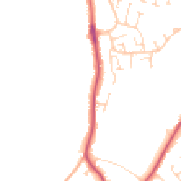
Daytime· 07:00 – 23:00
46.3dB

Night-time· 23:00 – 07:00
38.4dB