13 Queens Road, St George, Bristol, BS5 8HR
About 13 Queens Road
13 Queens Road is a mid-terrace house in St. George, Bristol, Bristol (BS5 8HR). It has a recorded floor area of 109 m² (around 1173 sq ft), construction records dating it to 1900-1929 and council tax band C. The latest certificate (August 2020) shows an E (score 41), well below the UK norm with real room to improve. The recommended improvements would lift it to B (score 86), a 3-band jump.
Today's modelled estimate of £416,000 is 28% above the 2021 sale price. On a £-per-square-foot basis, the last sale (£277/sq ft) was about 73.2% above the typical sold price in the postcode. Sold February 2021 for £325,000. That sale was during the post-pandemic price surge, when transactions cleared materially above pre-2020 trend.
Everything you need to know about 13 Queens Road
The true value, the hidden risks and the full sale history, in one report.
30-day money-back guarantee

The data behind every report


Energy performance
13 Queens Road's carbon output runs well above what efficient homes in the postcode produce.
EPC Rating
Planning history
13 Queens Road has no planning applications on record.
Notable planning nearby
10applications of note in the surrounding area
We flagged 2 things worth checking at 13 Queens Road
Independent checks surfaced things a buyer would want to understand before offering. The report explains each one in full, with the underlying data and what to ask.
- Signs of HMO activity in the area
- Larger development activity nearby
30-day money-back guarantee
Sales history & valuation
The latest sale landed in the post-pandemic price surge — useful context when reading the figure.
£416,000
Modelled from EPC, postcode comparables.
£325,000
Recorded with HM Land Registry.
Sales timeline
26 February 2021Most recent
£325,000
Median price across the last 5 sales in BS5 8HR: £374,000 (2022–2020).
Nearby sales in BS5 8HR
12 Queens Road, St George, Bristol, BS5 8HR
Sold Nov 2022
£415,0001 Queens Road, St George, Bristol, BS5 8HR
Sold Jun 2022
£355,00016 Queens Road, St George, Bristol, BS5 8HR
Sold Dec 2021
£427,00014 Queens Road, St George, Bristol, BS5 8HR
Sold Aug 2020
£374,0002 Queens Road, St George, Bristol, BS5 8HR
Sold Aug 2019
£265,000
Versus other Queens Road homes
EPC Rating for 13 Queens Road lags the street by a wide margin.
Price per m²
£2,982
Street avg £2,471
Floor Area
109 m²
Street avg 118 m²
Habitable Rooms
5 rooms
Street avg 6 rooms
CO₂ Emissions
7.3 t/year
Street avg 6.6 t/year
Everything you need to know about 13 Queens Road
The true value, the hidden risks and the full sale history, in one report.
30-day money-back guarantee
The data behind every report
Similar properties nearby
The neighbourhood at a glance
Daytime road noise here sits well below conversation level — a quiet pocket of the postcode.
Crime
11/mo
Steady year-on-year across the wider district.
Nearest stop
0.1 km
The Avenue — bus stop.
Closest school
0.3 km
Summerhill Infant School. 44 schools nearby.
Go deeper on the local area
The full report breaks down crime, transport links, schools and air quality in depth.
Road noise across the postcode
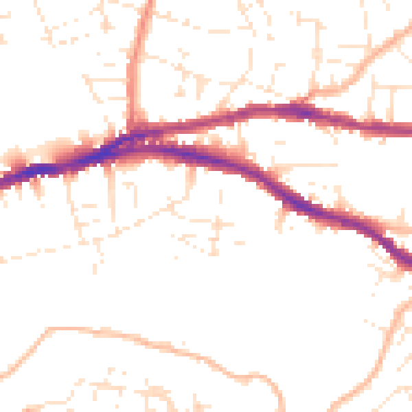
Daytime· 07:00 – 23:00
49.6dB

Night-time· 23:00 – 07:00
40.1dB