5 Chessel Drive, Patchway, Bristol, BS34 5BH
About 5 Chessel Drive
5 Chessel Drive is a detached house in Patchway, Bristol, Bristol (BS34 5BH). It has a recorded floor area of 138 m² (around 1485 sq ft) and council tax band E. The latest certificate (February 2014) returns a B (score 84), comfortably above the UK average. The latest certificate is from February 2014, so improvements made since then won't be reflected.
At 138 m² the property is well over the postcode median (84 m² across 57 EPCs), placing it in the larger end of the local stock. Today's modelled estimate of £500,000 sits 51.5% above the 2014 sale of £330,000. On a £-per-square-foot basis, the last sale (£222/sq ft) was about 16.4% below the postcode norm. Last changed hands 12 years ago, in March 2014.
Everything you need to know about 5 Chessel Drive
The true value, the hidden risks and the full sale history, in one report.
Pick your report · every report is £14.99
One time fee only - money back guarantee

The data behind every report


Energy performance
5 Chessel Drive's EPC is over a decade old — improvements since won't be reflected.
EPC Expired
This certificate is over 10 years old and is no longer valid.Expired 28 Feb 2024
EPC Rating
Get a survey for this property
Level 2 HomeBuyer Report
We've checked 10 risk factors against the available data for this property and believe a Level 2 HomeBuyer Report could be a suitable option for you.
From £695 · Includes VAT
Planning history
5 Chessel Drive has no planning applications on record.
But the area is active
11 notable applications nearby — larger schemes and conversions that could reshape the street. The report maps them all.
Sales history & valuation
5 Chessel Drive valuation sits well clear of the typical sold price in this postcode.
£500,000
Modelled from EPC, postcode comparables.
£330,000
Recorded with HM Land Registry.
Sales timeline
28 March 2014Most recent
£330,000
Median price across the last 5 sales in BS34 5BH: £510,000 (2024–2022).
Nearby sales in BS34 5BH
58 Chessel Drive, Patchway, Bristol, BS34 5BH
Sold Jun 2024
£529,00028 Chessel Drive, Patchway, Bristol, BS34 5BH
Sold Feb 2024
£510,00032 Chessel Drive, Patchway, Bristol, BS34 5BH
Sold Feb 2024
£510,00072 Chessel Drive, Patchway, Bristol, BS34 5BH
Sold Sept 2023
£480,00022 Chessel Drive, Patchway, Bristol, BS34 5BH
Sold Sept 2022
£495,000
Versus other Chessel Drive homes
On price per m², 5 Chessel Drive runs well behind the street norm.
Price per m²
£2,391
Street avg £3,064
Floor Area
138 m²
Street avg 103 m²
CO₂ Emissions
2.0 t/year
Street avg 1.8 t/year
Years Held
12 years
Street avg 9 years
Everything you need to know about 5 Chessel Drive
The true value, the hidden risks and the full sale history, in one report.
Pick your report · every report is £14.99
One time fee only - money back guarantee
The data behind every report
Similar properties nearby
1 Chessel Drive, Patchway
BS34 5BH
1 Broad Leaze, Patchway
BS34 5GW
1 Brighton Road, Patchway
BS34 5EL
1 Eamoth Ground, Patchway
BS34 5SR
1 Broad Croft, Patchway
BS34 5FS
1 Buckleys Road, Patchway
BS34 5BJ
1 Calves Garden, Patchway
BS34 5GZ
1 Clermont Close, Patchway
BS34 5QJ
The neighbourhood at a glance
Rail-style transport is unusually close for this postcode.
Crime
6/mo
Steady year-on-year across the wider district.
Nearest stop
0.2 km
Wood Street — bus stop.
Closest school
0.2 km
Charlton Wood Primary Academy. 23 schools nearby.
Go deeper on the local area
A Local Area report breaks down crime, transport links, schools and air quality in depth.
Road noise across the postcode
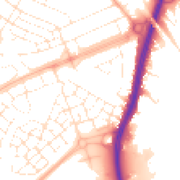
Daytime· 07:00 – 23:00
52.8dB
Night-time· 23:00 – 07:00
42.5dB