436a, Holdenhurst Road, Bournemouth, BH8 9AA
About 436a
436a is a four-bedroom semi-detached house in Bournemouth (BH8 9AA). It has a recorded floor area of 88 m² (around 947 sq ft) and construction records dating it to 1930-1949. The latest certificate (September 2023) shows a C (score 70). When first surveyed in September 2013 the rating was D, the property has climbed 1 band since. Between certificates, lighting went from Good to Very Good.
At 88 m² the property is well over the postcode median (57 m² across 12 EPCs), placing it in the larger end of the local stock. Across 2000–2014, sale prices on this property compounded at 9.3% per year. Today's modelled estimate of £333,000 is 23.3% above the 2014 sale price. On a £-per-square-foot basis, the last sale (£285/sq ft) was about 140.1% above the typical sold price in the postcode. On the market in August 2014 and unlisted since — roughly 12 years.
What this property has
Inside
- Bedrooms4
- Bathrooms1
- Dining roomYes
Building
- Heating systemGas
- RefurbishedYes
Everything you need to know about 436a
The true value, the hidden risks and the full sale history, in one report.
Pick your report · every report is £14.99
One time fee only - money back guarantee

The data behind every report


Energy performance
EPC Rating
Property Improvements
Changes detected from historical EPC data
More low energy lighting installed
Get a survey for this property
Level 3 Building Survey
Because the property has been extended more than once, we believe a Level 3 building survey should be considered.
From £955 · Includes VAT
Planning history
436a has no planning applications on record.
But the area is active
7 notable applications nearby — larger schemes and conversions that could reshape the street. The report maps them all.
Sales history & valuation
436a has more than tripled in price since its earliest registered sale in 2000.
£333,000
Modelled from EPC, postcode comparables and a sale-price growth of 9.3% per year over 14 years.
£270,000
Growth on file: 9.3% per year over 14 years.
Sales timeline
19 August 2014Most recent
£270,000
+45.9%over 4 years16 August 2010
£185,000
+145.0%over 10 years24 March 2000
£75,500
Median price across the last 3 sales in BH8 9AA: £74,000 (2023–1999).
Versus other Holdenhurst Road homes
Floor Area for 436a runs comfortably ahead of the street norm.
Price per m²
£3,068
Street avg £4,973
Floor Area
88 m²
Street avg 57 m²
Habitable Rooms
5 rooms
Street avg 3 rooms
CO₂ Emissions
2.9 t/year
Street avg 2.6 t/year
Everything you need to know about 436a
The true value, the hidden risks and the full sale history, in one report.
Pick your report · every report is £14.99
One time fee only - money back guarantee
The data behind every report
Similar properties nearby
The neighbourhood at a glance
Crime
14/mo
Steady year-on-year across the wider district.
Nearest stop
0.0 km
St Marys Church — bus stop.
Closest school
0.5 km
King's Park Academy. 24 schools nearby.
Go deeper on the local area
A Local Area report breaks down crime, transport links, schools and air quality in depth.
Road noise across the postcode
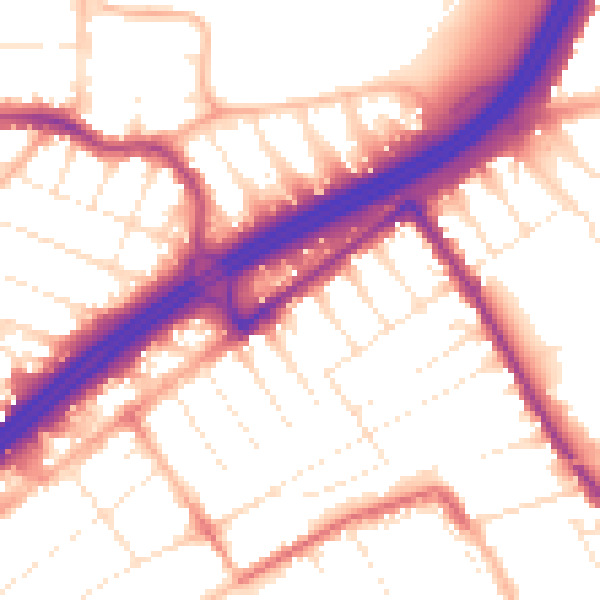
Daytime· 07:00 – 23:00
55.1dB

Night-time· 23:00 – 07:00
45.8dB