19 Arncliffe Drive, Knottingley, WF11 8PU
3 sales on record
About 19 Arncliffe Drive
A plain-English summary derived from public records, EPC certificates, sold prices and local data.
19 Arncliffe Drive is a two-bedroom semi-detached house in Knottingley (WF11 8PU). It has a recorded floor area of 52 m² (around 560 sq ft), construction records dating it to 1976-1982 and council tax band B. The latest certificate (June 2025) shows a D (score 67), on the cusp of jumping into the C band. When first surveyed in March 2009 the rating was F, the property has climbed 2 bands since. Between certificates, wall efficiency went from Poor to Good, roof efficiency went from Poor to Very Good and hot-water efficiency went from Poor to Good; while window efficiency dropped from Average to Poor. The recommended improvements would push it to C (score 75).
Sale prices here have outpaced England HPI: 4.7% per year against 0.1% for the wider region. On a £-per-square-foot basis, the last sale (£322/sq ft) was about 111.9% above the typical sold price in the postcode. A recent sale: £180,000 in October 2025. At 52 m² it's 21.2% smaller than the typical home in the postcode (66 m² median across 11 EPCs).
What this property has
Pulled from EPC certificates, claim submissions and our property model. Empty categories are hidden — we only show what's known.
Inside
- Bedrooms2
- Bathrooms1
- EnsuiteYes
Outside
- Private garden
Energy performance
Every EPC certificate filed against this property — current rating, recorded improvements, and where there's headroom to reach a higher band.
Current Certificate(1 of 2)
Jun 2025
EPC Rating
A
B
C
D
D67
E
F
G
Main Heating
Gas
Main Fuel
Gas
Hot Water
Good
Windows
Poor
CO2 Emissions
2.0 t/year
Occupancy
Owner Occupied
Planning history
Applications and permits filed against 19 Arncliffe Drive, Knottingley, WF11 8PU, sourced from the PlanIt planning register.
No planning applications are recorded against 19 Arncliffe Drive, Knottingley, WF11 8PU. The full report also covers planning activity across the surrounding area.
Full planning data for 19 Arncliffe Drive, Knottingley, WF11 8PU
Every application and decision on this property and nearby, in full, in the report.
Sales history & valuation
Recorded transactions, our model's current estimate, and a quick read on what neighbouring properties have sold for.
Latest sale on 19 Arncliffe Drive was the highest on Land Registry record across the postcode.
Current estimate
See how we calculated this£180,000
Modelled from EPC, postcode comparables and a sale-price growth of 4.7% per year over 16 years.
Last sold (2025)
£180,000
Growth on file: 4.7% per year over 16 years.
Sales timeline
Launch offer · 33% off
The complete analysis of 19 Arncliffe Drive, Knottingley, WF11 8PU
Everything we know about this property, compiled into one in-depth, downloadable report.
Detailed analysis
A written breakdown of everything that matters
Versus other Arncliffe Drive homes
Four headline reads against 11 similar houses on this street, drawn from the latest EPC and Land Registry data.
On price per m², 19 Arncliffe Drive stands well clear of the street.
Price per m²
£3,462
Street avg £1,932
Floor Area
52 m²
Street avg 70 m²
Habitable Rooms
4 rooms
Similar properties nearby
A handful of close matches in the same postcode area, ranked by likeness on bedrooms, type and floor area.
The neighbourhood at a glance
A condensed read of the local area. Each tile links through to the full breakdown on the Knottingley district page.
Rail-style transport is unusually close for this postcode.
Crime
5/mo
Steady year-on-year across the wider district.
Nearest stop
0.0 km
Arncliffe Drive St Andrews Dr — bus stop.
Road noise across the postcode
Modelled day and night-time noise levels around WF11 8PU from Defra's strategic mapping. The pin marks this postcode's centroid.
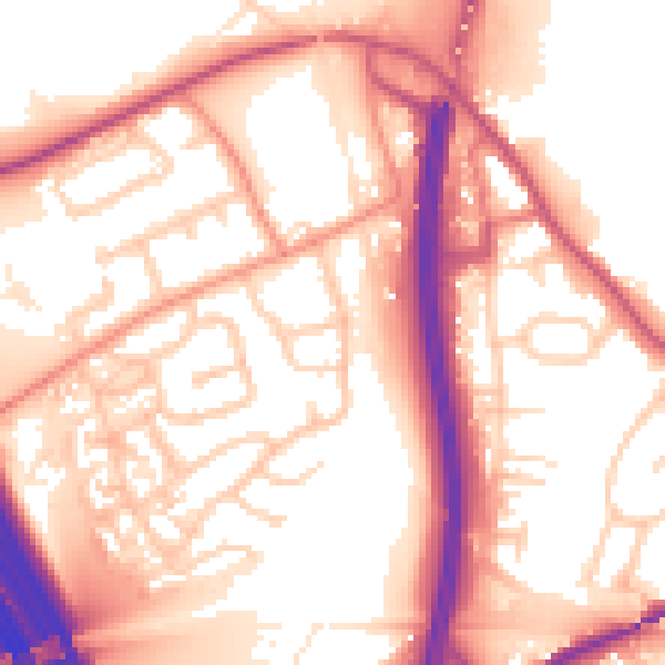
Daytime· 07:00 – 23:00
56.8dB

Everything within walking distance
Schools, transport stops and scenic spots near this property — 43 points of interest in total.
Common questions
The questions buyers, sellers and homeowners most often ask about 19 Arncliffe Drive, Knottingley, WF11 8PU. Each answer is also embedded as structured data for search engines.
