63a, Weeland Road, Knottingley, WF11 8BG
About 63a
A plain-English summary derived from public records, EPC certificates, sold prices and local data.
63a is a one-bedroom detached house in Knottingley (WF11 8BG). It has a recorded floor area of 54 m² (around 581 sq ft), construction records dating it to 1930-1949 and council tax band A. At 54 m² this is the 11th smallest of 20 units on EPC record in the building, where floor areas span 23–122 m². The building's EPC ratings span E to C, with this unit at the bottom. On EPC score it ranks last in the building (39 versus a best of 76). The latest certificate (April 2021) shows an E (score 39), well below the UK norm with real room to improve. The recommended improvements would push it to D (score 67). Main heating runs on electricity.
Held since July 1995 — that's 31 years off the open market, well above the local norm. Sale prices here have outpaced England HPI: 75% per year against 0% for the wider region. Today's modelled estimate of £124,000 sits 254.3% above the 1995 sale of £35,000. On a £-per-square-foot basis, the last sale (£60/sq ft) was about 44.7% below the postcode norm. At 54 m² it's 17.4% larger than the typical home in the postcode (46 m² median across 19 EPCs). 1 bedrooms is on the smaller side for this postcode, where 3 is the typical count.
Before you offer
Know exactly what you're buying at 63a
Before you offer, see what the listing won't tell you, the true value, the red flags and the full history.
Already flagged here
Larger development activity nearbyRecent ownership pattern worth a look
£9.99£14.99
Launch offer · save £5
What this property has
Pulled from EPC certificates, claim submissions and our property model. Empty categories are hidden — we only show what's known.
Inside
- Bedrooms1
- Bathrooms1
Outside
- Private gardenfront
- Parking
Energy performance
Every EPC certificate filed against this property — current rating, recorded improvements, and where there's headroom to reach a higher band.
63a's carbon output runs well above what efficient homes in the postcode produce.
EPC Rating
A
B
C
D
E
E39
F
G
Main Heating
Electric
Main Fuel
Electric
Hot Water
Average
Windows
Average
CO2 Emissions
7.4 t/year
Occupancy
Rented
Planning history
Applications and permits filed against 63a, Weeland Road, Knottingley, WF11 8BG, sourced from the PlanIt planning register.
63a has no planning applications on record.
Notable planning nearby
4applications of note in the surrounding area
Before you offer
We flagged 2 things worth checking at 63a
Independent checks surfaced things a buyer would want to understand before offering. The report explains each one in full, with the underlying data and what to ask.
- Larger development activity nearby
Sales history & valuation
Recorded transactions, our model's current estimate, and a quick read on what neighbouring properties have sold for.
Latest sale on 63a was the lowest on Land Registry record across the postcode.
Current estimate
See how we calculated this£124,000
Modelled from EPC, postcode comparables and a sale-price growth of 75.0% per year over 1 year.
Last sold (1995)
£35,000
Growth on file: 75.0% per year over 1 year.
Sales timeline
Before you offerLaunch offer · save £5
Everything we know about 63a, in one report
What it's really worth, what could be wrong, and the planning, sales and area data in full.
What we flagged
- Larger development activity nearby
- Recent ownership pattern worth a look
£9.99£14.99
Versus other Weeland Road homes
Four headline reads against 14 similar flats on this street, drawn from the latest EPC and Land Registry data.
63a is notably below the street on epc rating.
EPC Rating
39 (E)
Street avg 56 (D)
Floor Area
54 m²
Street avg 42 m²
CO₂ Emissions
7.4 t/year
Street avg 4.4 t/year
Similar properties nearby
A handful of close matches in the same postcode area, ranked by likeness on bedrooms, type and floor area.
The neighbourhood at a glance
A condensed read of the local area. Each tile links through to the full breakdown on the Knottingley district page.
Crime
5/mo
Steady year-on-year across the wider district.
Nearest stop
0.1 km
Common Lane — bus stop.
Road noise across the postcode
Modelled day and night-time noise levels around WF11 8BG from Defra's strategic mapping. The pin marks this postcode's centroid.
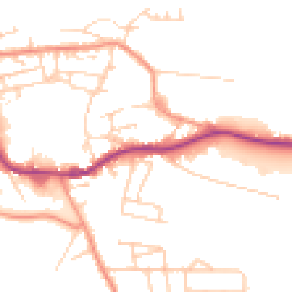
Daytime· 07:00 – 23:00
50.2dB

Everything within walking distance
Schools, transport stops and scenic spots near this property — 36 points of interest in total.
Common questions
The questions buyers, sellers and homeowners most often ask about 63a, Weeland Road, Knottingley, WF11 8BG. Each answer is also embedded as structured data for search engines.
