109 North Western Avenue, Watford, WD25 0AQ
About 109 North Western Avenue
109 North Western Avenue is a semi-detached house in Watford (WD25 0AQ). It has a recorded floor area of 45 m² (around 484 sq ft), construction records dating it to 1930-1949 and council tax band B. The latest certificate (April 2025) shows an E (score 52), well below the UK norm with real room to improve. The recommended improvements would lift it to C (score 77), a 2-band jump.
At 45 m² it sits well below the postcode median (71 m² across 21 EPCs), making it one of the more compact homes locally.
Everything you need to know about 109 North Western Avenue
The true value, the hidden risks and the full sale history, in one report.
30-day money-back guarantee

The data behind every report


Energy performance
Recommended upgrades on file would lift this property by multiple EPC bands.
EPC Rating
Planning history
109 North Western Avenue has no planning applications on record.
Notable planning nearby
2applications of note in the surrounding area
Sales history & valuation
109 North Western Avenue has no Land Registry sales on file, suggesting it has stayed in the same hands since registration began.
£225,000
Modelled from EPC, postcode comparables.
No sales recorded with HM Land Registry
That can mean the property has never traded since the registry began publishing in 1995, was a new build that hasn't been registered yet, or is held in the same hands long-term.
Median price across the last 5 sales in WD25 0AQ: £285,000 (2025–2021).
Nearby sales in WD25 0AQ
129 North Western Avenue, Watford, WD25 0AQ
Sold Mar 2025
£285,000111 North Western Avenue, Watford, WD25 0AQ
Sold May 2024
£227,000111a, North Western Avenue, Watford, WD25 0AQ
Sold May 2024
£250,000135 North Western Avenue, Watford, WD25 0AQ
Sold May 2022
£440,700137 North Western Avenue, Watford, WD25 0AQ
Sold Sept 2021
£460,000
Versus other North Western Avenue homes
Floor Area for 109 North Western Avenue lags the street by a wide margin.
EPC Rating
52 (E)
Street avg 52 (E)
Floor Area
45 m²
Street avg 56 m²
CO₂ Emissions
3.3 t/year
Street avg 3.6 t/year
Habitable Rooms
2 rooms
Street avg 2 rooms
Everything you need to know about 109 North Western Avenue
The true value, the hidden risks and the full sale history, in one report.
30-day money-back guarantee
The data behind every report
Similar properties nearby
The neighbourhood at a glance
Crime
4/mo
Steady year-on-year across the wider district.
Nearest stop
0.4 km
Library — bus stop.
Closest school
0.3 km
Cherry Tree Primary School. 29 schools nearby.
Go deeper on the local area
The full report breaks down crime, transport links, schools and air quality in depth.
Road noise across the postcode
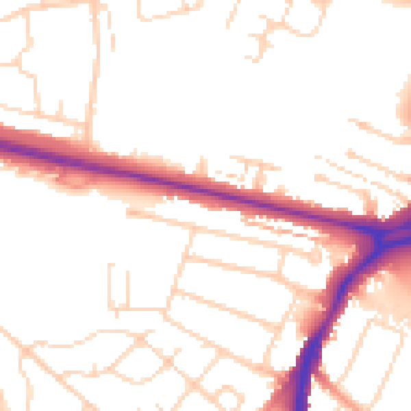
Daytime· 07:00 – 23:00
51.3dB

Night-time· 23:00 – 07:00
42.1dB