17a, Essex Road, Watford, WD17 4EL
About 17a
17a is a two-bedroom semi-detached house in Watford (WD17 4EL). It has a recorded floor area of 60 m² (around 646 sq ft), construction records dating it to before 1900 and council tax band C. The latest certificate (November 2018) shows a D (score 55), a step below the typical UK home. The rating has held steady at D across 2 certificates since August 2009. Between certificates, lighting went from Poor to Good. The recommended improvements would push it to C (score 76). Period features are noted in the property record.
2 planning records sit against the property, 1 approved, 0 refused. Past consents include tree works, meaningful when judging how the property has evolved. The record references conservation-area consent, which constrain future alterations. At 60 m² it sits well below the postcode median (108 m² across 19 EPCs), making it one of the more compact homes locally. Last sale on file: £310,000 in December 2020. Across the public record there are 4 sales, relatively high churn for a single property. Across 2003–2020, sale prices on this property compounded at 4.9% per year. On a £-per-square-foot basis, the last sale (£480/sq ft) was about 97.5% above the typical sold price in the postcode.
What this property has
Inside
- Bedrooms2
- Bathrooms1
Outside
- Private gardenYes
Building
- Central heatingYes
- Period featuresYes
- RefurbishedYes
Everything you need to know about 17a
The true value, the hidden risks and the full sale history, in one report.
30-day money-back guarantee

The data behind every report


Energy performance
EPC Rating
Property Improvements
Changes detected from historical EPC data
Heating controls changed
More low energy lighting installed
Planning history
17a sits within a conservation area — exterior works face additional planning controls.
- Jun 2020Tree WorksTreesIn report
Remove 2no. trees in rear garden (Nascot Conservation Area)
Conservation Area- Documents
- 10 docs on file
- Reference
- 20/00496/TCA
- Aug 2007RenovationFullIn report
Reinstatement of front bay window.
New Windows- Documents
- 22 docs on file
- Reference
- 07/00695/FUL
What's in 17a, Essex Road, Watford, WD17 4EL's planning history?
Refusals, disputes and full decisions on this property and nearby, in the report.
Sales history & valuation
Sale price has at least doubled since 2003.
£332,000
Modelled from EPC, postcode comparables and a sale-price growth of 4.9% per year over 18 years.
£310,000
Growth on file: 4.9% per year over 18 years.
Sales timeline
7 December 2020Most recent
£310,000
+10.7%over 5 years9 April 2015
£280,000
+66.7%over 8 years12 January 2007
£168,000
+26.8%over 3 years16 April 2003
£132,500
Median price across the last 5 sales in WD17 4EL: £310,000 (2024–2020).
Nearby sales in WD17 4EL
Versus other Essex Road homes
Habitable Rooms for 17a runs comfortably ahead of the street norm.
Price per m²
£5,167
Street avg £3,100
Floor Area
60 m²
Street avg 63 m²
Habitable Rooms
3 rooms
Street avg 2 rooms
CO₂ Emissions
3.8 t/year
Street avg 2.8 t/year
Everything you need to know about 17a
The true value, the hidden risks and the full sale history, in one report.
30-day money-back guarantee
The data behind every report
Similar properties nearby
1 Arden Court, Lockhart Road
WD17 4AQ
1 Bromet Close
WD17 4LP
1 Biskra, Langley Road
WD17 4PF
1 Burrow Close
WD17 4DS
1 Fairlawns, Langley Road
WD17 4UH
1 Elton Park
WD17 4NW
1 Cole Road
WD17 4QR
1 Greenbank Road
WD17 4JJ
The neighbourhood at a glance
Rail-style transport is unusually close for this postcode.
Crime
10/mo
Steady year-on-year across the wider district.
Nearest stop
0.1 km
Town Hall — bus stop.
Closest school
0.3 km
Lanchester Primary School. 38 schools nearby.
Go deeper on the local area
The full report breaks down crime, transport links, schools and air quality in depth.
Road noise across the postcode
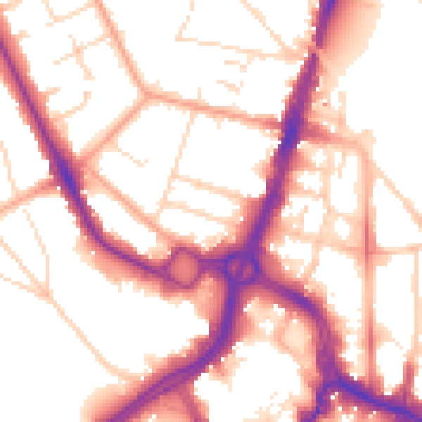
Daytime· 07:00 – 23:00
54.4dB

Night-time· 23:00 – 07:00
45.0dB