18 Barham Court, Birchwood, Warrington, WA3 6ND
About 18 Barham Court
18 Barham Court is a three-bedroom mid-terrace house in Birchwood, Warrington, Warrington (WA3 6ND). It has a recorded floor area of 90 m² (around 969 sq ft), construction records dating it to 1976-1982 and council tax band A. The latest certificate (October 2013) shows a D (score 66), on the cusp of jumping into the C band. The recommended improvements would lift it to B (score 89), a 2-band jump. The latest certificate is from October 2013, so improvements made since then won't be reflected.
Today's modelled estimate of £182,000 sits 114.1% above the 2013 sale of £85,000. On a £-per-square-foot basis, the last sale (£88/sq ft) was about 29% below the postcode norm. Last sold in December 2013, so it's been off the market for around 12 years.
What this property has
Inside
- Bedrooms3
Everything you need to know about 18 Barham Court
The true value, the hidden risks and the full sale history, in one report.
Pick your report · every report is £14.99
One time fee only - money back guarantee

The data behind every report


Energy performance
Recommended upgrades on file would lift this property by multiple EPC bands.
EPC Expired
This certificate is over 10 years old and is no longer valid.Expired 02 Oct 2023
EPC Rating
Get a survey for this property
Level 2 HomeBuyer Report
We've checked 10 risk factors against the available data for this property and believe a Level 2 HomeBuyer Report could be a suitable option for you.
From £495 · Includes VAT
Planning history
18 Barham Court has no planning applications on record.
A planning report still maps activity across the surrounding area and reads this property's extension & conversion potential.
Sales history & valuation
18 Barham Court valuation sits well clear of the typical sold price in this postcode.
£182,000
Modelled from EPC, postcode comparables.
£85,000
Recorded with HM Land Registry.
Sales timeline
6 December 2013Most recent
£85,000
Median price across the last 5 sales in WA3 6ND: £175,250 (2025–2019).
Nearby sales in WA3 6ND
5 Barham Court, Birchwood, Warrington, WA3 6ND
Sold Jun 2025
£233,00021 Barham Court, Birchwood, Warrington, WA3 6ND
Sold Jul 2024
£175,25010 Barham Court, Birchwood, Warrington, WA3 6ND
Sold Feb 2022
£120,00017 Barham Court, Birchwood, Warrington, WA3 6ND
Sold Oct 2019
£130,0001 Barham Court, Birchwood, Warrington, WA3 6ND
Sold Apr 2019
£130,000
Versus other Barham Court homes
Price per m² for 18 Barham Court lags the street by a wide margin.
Price per m²
£944
Street avg £1,531
Floor Area
90 m²
Street avg 85 m²
Habitable Rooms
5 rooms
Street avg 5 rooms
CO₂ Emissions
3.6 t/year
Street avg 3.5 t/year
Everything you need to know about 18 Barham Court
The true value, the hidden risks and the full sale history, in one report.
Pick your report · every report is £14.99
One time fee only - money back guarantee
The data behind every report
Similar properties nearby
1 Bowland Close, Birchwood
WA3 6TJ
1 Burrough Close, Birchwood
WA3 6QF
1 Armstrong Close, Birchwood
WA3 6DH
1 Barham Court, Birchwood
WA3 6ND
1 Bramshill Close, Birchwood
WA3 6TY
1 Colebrooke Close, Birchwood
WA3 6RY
1 Dove Close, Birchwood
WA3 6QH
1 Curlew Grove, Birchwood
WA3 6NX
The neighbourhood at a glance
Crime
1/mo
Steady year-on-year across the wider district.
Nearest stop
0.1 km
Heathfield House — bus stop.
Closest school
0.5 km
Locking Stumps Community Primary School. 16 schools nearby.
Go deeper on the local area
A Local Area report breaks down crime, transport links, schools and air quality in depth.
Road noise across the postcode
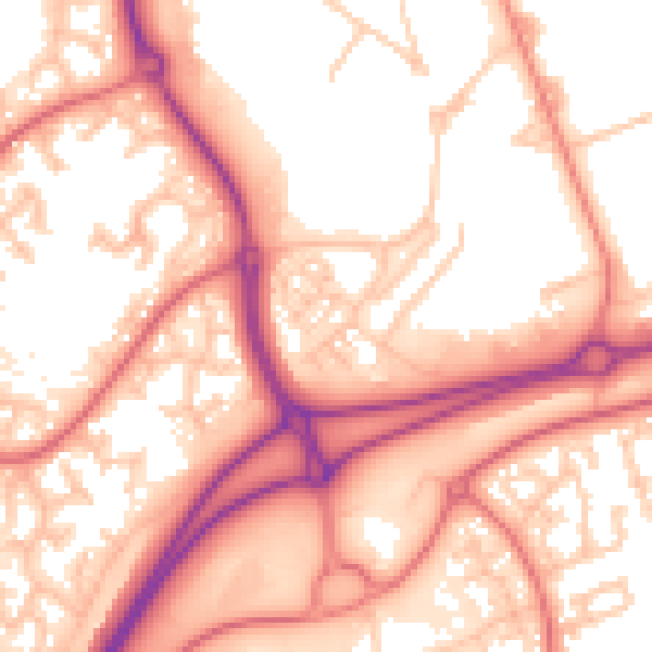
Daytime· 07:00 – 23:00
56.8dB
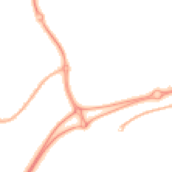
Night-time· 23:00 – 07:00
47.9dB