82 Newton Road, Lowton, Warrington, WA3 1DG
About 82 Newton Road
82 Newton Road is a two-bedroom mid-terrace house in Lowton, Warrington, Warrington (WA3 1DG). It has a recorded floor area of 85 m² (around 915 sq ft), construction records dating it to 1950-1966 and council tax band A. The latest certificate (December 2019) shows a D (score 66), on the cusp of jumping into the C band. The recommended improvements would lift it to B (score 82), a 2-band jump.
It changed hands recently, sold April 2025 for £145,000. Across 1999–2025, sale prices on this property compounded at 6% per year. Today's modelled estimate of £170,000 is 17.2% above the 2025 sale price. On a £-per-square-foot basis, the last sale (£158/sq ft) was about 53.5% above the typical sold price in the postcode.
What this property has
Inside
- Bedrooms2
- Bathrooms1
- Dining roomYes
Outside
- GarageDetached
Everything you need to know about 82 Newton Road
The true value, the hidden risks and the full sale history, in one report.
Pick your report · every report is £14.99
One time fee only - money back guarantee

The data behind every report


Energy performance
Recommended upgrades on file would lift this property by multiple EPC bands.
EPC Rating
Get a survey for this property
Level 3 Building Survey
Because the property has solid (non-cavity) walls, we believe a Level 3 building survey should be considered.
From £820 · Includes VAT
Planning history
82 Newton Road has no planning applications on record.
A planning report still maps activity across the surrounding area and reads this property's extension & conversion potential.
Sales history & valuation
82 Newton Road has more than quadrupled in price since its earliest registered sale in 1999.
£170,000
Modelled from EPC, postcode comparables and a sale-price growth of 6.0% per year over 26 years.
£145,000
Growth on file: 6.0% per year over 26 years.
Sales timeline
15 April 2025Most recent
£145,000
+346.2%over 25 years7 October 1999
£32,500
Median price across the last 5 sales in WA3 1DG: £152,000 (2025–2023).
Nearby sales in WA3 1DG
166 Newton Road, Lowton, Warrington, WA3 1DG
Sold May 2025
£132,950164 Newton Road, Lowton, Warrington, WA3 1DG
Sold Jan 2025
£195,00084 Newton Road, Lowton, Warrington, WA3 1DG
Sold Dec 2024
£130,000126 Newton Road, Lowton, Warrington, WA3 1DG
Sold Dec 2023
£152,000148 Newton Road, Lowton, Warrington, WA3 1DG
Sold Sept 2023
£155,000
Versus other Newton Road homes
82 Newton Road is notably below the street on years held.
Price per m²
£1,706
Street avg £1,575
Floor Area
85 m²
Street avg 93 m²
Habitable Rooms
4 rooms
Street avg 5 rooms
CO₂ Emissions
3.3 t/year
Street avg 3.9 t/year
Everything you need to know about 82 Newton Road
The true value, the hidden risks and the full sale history, in one report.
Pick your report · every report is £14.99
One time fee only - money back guarantee
The data behind every report
Similar properties nearby
1 Chapel Terrace, Lowton
WA3 1EF
1 Carr Lane, Lowton
WA3 1AF
1 Bodden Street, Lowton
WA3 1DX
1 Heathmoor Avenue, Lowton
WA3 1HP
1 Clayhill Grove, Lowton
WA3 1FZ
1 Adwell Close, Lowton
WA3 1DE
1 Kirkham Avenue, Lowton
WA3 1LL
1 Glastonbury Avenue, Lowton
WA3 1ET
The neighbourhood at a glance
Daytime road noise here sits well below conversation level — a quiet pocket of the postcode.
Crime
1/mo
Steady year-on-year across the wider district.
Nearest stop
0.0 km
Morgans Way — bus stop.
Closest school
0.2 km
Lowton St Mary's CofE (Voluntary Aided) Primary School. 12 schools nearby.
Go deeper on the local area
A Local Area report breaks down crime, transport links, schools and air quality in depth.
Road noise across the postcode
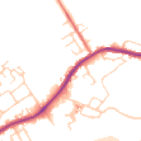
Daytime· 07:00 – 23:00
49.9dB

Night-time· 23:00 – 07:00
43.5dB