17 Monkmoor Road, Shrewsbury, SY2 5AG
About 17 Monkmoor Road
17 Monkmoor Road is a three-bedroom semi-detached house in Shrewsbury (SY2 5AG). It has a recorded floor area of 91 m² (around 980 sq ft), construction records dating it to before 1900 and council tax band A. The latest certificate (April 2015) shows an E (score 51), well below the UK norm with real room to improve. The recommended improvements would lift it to B (score 85), a 3-band jump. The latest certificate is from April 2015, so improvements made since then won't be reflected.
Today's modelled estimate of £317,000 is 49.2% above the 2015 sale price. On a £-per-square-foot basis, the last sale (£217/sq ft) was about 17.8% above the typical sold price in the postcode. Last sold in June 2015, so it's been off the market for around 11 years.
What this property has
Inside
- Bedrooms3
- Bathrooms1
Everything you need to know about 17 Monkmoor Road
The true value, the hidden risks and the full sale history, in one report.
30-day money-back guarantee

The data behind every report


Energy performance
Recommended upgrades on file would lift this property by multiple EPC bands.
EPC Expired
This certificate is over 10 years old and is no longer valid.Expired 28 Apr 2025
EPC Rating
Planning history
17 Monkmoor Road has no planning applications on record.
Notable planning nearby
3applications of note in the surrounding area
We flagged 1 thing worth checking at 17 Monkmoor Road
Independent checks surfaced things a buyer would want to understand before offering. The report explains each one in full, with the underlying data and what to ask.
- Larger development activity nearby
30-day money-back guarantee
Sales history & valuation
17 Monkmoor Road valuation sits well clear of the typical sold price in this postcode.
£317,000
Modelled from EPC, postcode comparables.
£212,500
Recorded with HM Land Registry.
Sales timeline
8 June 2015Most recent
£212,500
Median price across the last 5 sales in SY2 5AG: £210,000 (2022–2015).
Nearby sales in SY2 5AG
Versus other Monkmoor Road homes
EPC Rating for 17 Monkmoor Road lags the street by a wide margin.
Price per m²
£2,335
Street avg £2,462
Floor Area
91 m²
Street avg 109 m²
Habitable Rooms
5 rooms
Street avg 6 rooms
CO₂ Emissions
5.9 t/year
Street avg 5.6 t/year
Everything you need to know about 17 Monkmoor Road
The true value, the hidden risks and the full sale history, in one report.
30-day money-back guarantee
The data behind every report
Similar properties nearby
The neighbourhood at a glance
Rail-style transport is unusually close for this postcode.
Crime
1/mo
Steady year-on-year across the wider district.
Nearest stop
0.9 km
Shrewsbury Rail Station — railway station.
Closest school
0.8 km
Coleham Primary School. 20 schools nearby.
Go deeper on the local area
The full report breaks down crime, transport links, schools and air quality in depth.
Road noise across the postcode
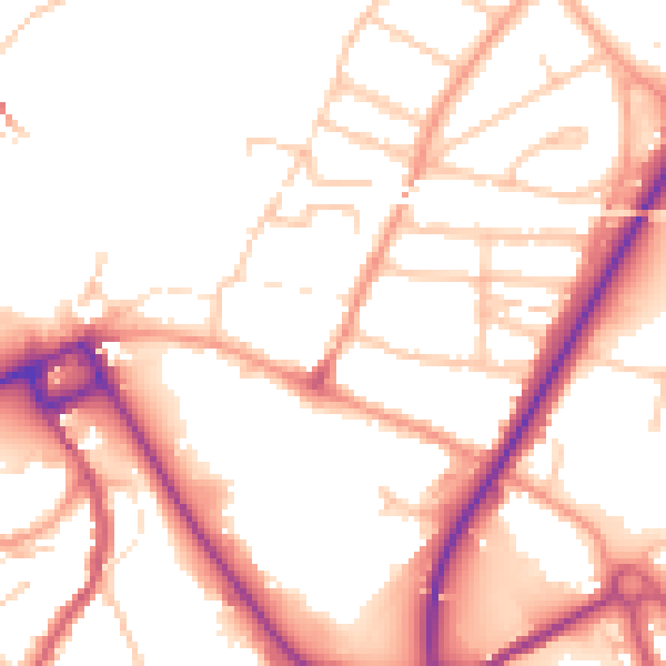
Daytime· 07:00 – 23:00
52.0dB

Night-time· 23:00 – 07:00
43.0dB