25 Baswich Lane, Stafford, ST17 0BH
About 25 Baswich Lane
25 Baswich Lane is a semi-detached house in Stafford (ST17 0BH). It has a recorded floor area of 114 m² (around 1227 sq ft), construction records dating it to 1900-1929 and council tax band D. The latest certificate (June 2025) shows a D (score 64), on the cusp of jumping into the C band. The recommended improvements would lift it to B (score 84), a 2-band jump.
Everything you need to know about 25 Baswich Lane
The true value, the hidden risks and the full sale history, in one report.
Pick your report · every report is £14.99
One time fee only - money back guarantee

The data behind every report


Energy performance
Recommended upgrades on file would lift this property by multiple EPC bands.
EPC Rating
Get a survey for this property
Level 3 Building Survey
Because the property was built before 1919 and has solid (non-cavity) walls, we believe a Level 3 building survey should be considered.
From £1,020 · Includes VAT
Planning history
25 Baswich Lane has no planning applications on record.
But the area is active
1 notable application nearby — larger schemes and conversions that could reshape the street. The report maps them all.
Sales history & valuation
25 Baswich Lane has no Land Registry sales on file, suggesting it has stayed in the same hands since registration began.
£423,000
Modelled from EPC, postcode comparables.
No sales recorded with HM Land Registry
That can mean the property has never traded since the registry began publishing in 1995, was a new build that hasn't been registered yet, or is held in the same hands long-term.
Median price across the last 5 sales in ST17 0BH: £530,000 (2025–2022).
Nearby sales in ST17 0BH
Versus other Baswich Lane homes
EPC Rating for 25 Baswich Lane runs comfortably ahead of the street norm.
EPC Rating
64 (D)
Street avg 53 (E)
Floor Area
114 m²
Street avg 118 m²
CO₂ Emissions
5.1 t/year
Street avg 7.5 t/year
Habitable Rooms
6 rooms
Street avg 6 rooms
Everything you need to know about 25 Baswich Lane
The true value, the hidden risks and the full sale history, in one report.
Pick your report · every report is £14.99
One time fee only - money back guarantee
The data behind every report
Similar properties nearby
1 Alsop Crest, Acton Trussell
ST17 0SJ
1 Briar Close
ST17 0NG
1 Bank Top Cottage, Top Road, Acton Trussell
ST17 0RQ
1 Barons Court, Wolseley Bridge
ST17 0XJ
1 Acton Hill Road, Acton Trussell
ST17 0RY
1 Baswich Lane
ST17 0BH
1 Belvedere Close
ST17 0AL
1 Bishton Lane, Wolseley Bridge
ST17 0XW
The neighbourhood at a glance
Crime
3/mo
Steady year-on-year across the wider district.
Nearest stop
0.2 km
Radford Bank — bus stop.
Closest school
0.3 km
St Anne's Catholic Primary School. 18 schools nearby.
Go deeper on the local area
A Local Area report breaks down crime, transport links, schools and air quality in depth.
Road noise across the postcode
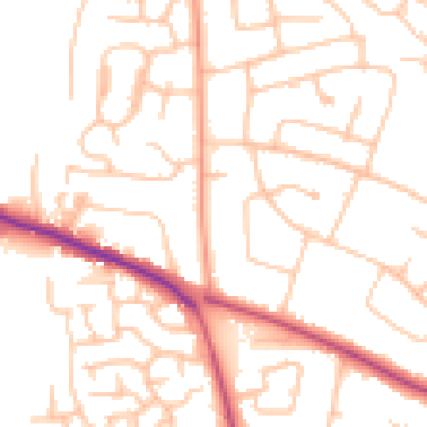
Daytime· 07:00 – 23:00
50.8dB

Night-time· 23:00 – 07:00
40.7dB