19 Brunswick Place, Stoke On Trent, ST1 3DD
About 19 Brunswick Place
19 Brunswick Place is a two-bedroom mid-terrace house in Stoke On Trent (ST1 3DD). It has a recorded floor area of 94 m² (around 1012 sq ft), construction records dating it to 1900-1929 and council tax band A. The latest certificate (June 2013) shows a D (score 67), on the cusp of jumping into the C band. The recommended improvements would lift it to B (score 86), a 2-band jump. The latest certificate is from June 2013, so improvements made since then won't be reflected.
Across 1997–2023, sale prices on this property compounded at 3.5% per year. Today's modelled estimate of £121,000 is 48.5% above the 2023 sale price. On a £-per-square-foot basis, the last sale (£81/sq ft) was about 24.7% above the typical sold price in the postcode. Sold July 2023 for £81,500.
What this property has
Inside
- Bedrooms2
- Bathrooms1
- Dining roomYes
Outside
- Private gardenYes
Everything you need to know about 19 Brunswick Place
The true value, the hidden risks and the full sale history, in one report.
Pick your report · every report is £14.99
One time fee only - money back guarantee

The data behind every report


Energy performance
Recommended upgrades on file would lift this property by multiple EPC bands.
EPC Expired
This certificate is over 10 years old and is no longer valid.Expired 26 Jun 2023
EPC Rating
Get a survey for this property
Level 3 Building Survey
Because the property was built before 1919 and has solid (non-cavity) walls, we believe a Level 3 building survey should be considered.
From £820 · Includes VAT
Planning history
19 Brunswick Place has no planning applications on record.
But the area is active
7 notable applications nearby — larger schemes and conversions that could reshape the street. The report maps them all.
Sales history & valuation
Sale price has at least doubled since 1997.
£121,000
Modelled from EPC, postcode comparables and a sale-price growth of 3.5% per year over 26 years.
£81,500
Growth on file: 3.5% per year over 26 years.
Sales timeline
13 July 2023Most recent
£81,500
+270.5%over 22 years14 June 2001
£22,000
-33.3%over 4 years3 June 1997
£33,000
Median price across the last 5 sales in ST1 3DD: £96,000 (2025–2020).
Nearby sales in ST1 3DD
17 Brunswick Place, Stoke On Trent, ST1 3DD
Sold Mar 2025
£135,0008 Brunswick Place, Stoke On Trent, ST1 3DD
Sold Sept 2022
£100,0005 Brunswick Place, Stoke On Trent, ST1 3DD
Sold Nov 2021
£95,00024 Brunswick Place, Stoke On Trent, ST1 3DD
Sold Mar 2021
£96,0003 Brunswick Place, Stoke On Trent, ST1 3DD
Sold Sept 2020
£66,000
Versus other Brunswick Place homes
On years held, 19 Brunswick Place runs well behind the street norm.
Price per m²
£867
Street avg £802
Floor Area
94 m²
Street avg 106 m²
Habitable Rooms
5 rooms
Street avg 5 rooms
CO₂ Emissions
3.6 t/year
Street avg 5.7 t/year
Everything you need to know about 19 Brunswick Place
The true value, the hidden risks and the full sale history, in one report.
Pick your report · every report is £14.99
One time fee only - money back guarantee
The data behind every report
Similar properties nearby
The neighbourhood at a glance
Crime
27/mo
Falling year-on-year across the wider district.
Nearest stop
0.1 km
Bus Station — bus station.
Closest school
0.3 km
Waterside Primary School. 32 schools nearby.
Go deeper on the local area
A Local Area report breaks down crime, transport links, schools and air quality in depth.
Road noise across the postcode
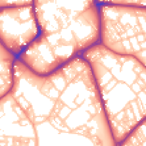
Daytime· 07:00 – 23:00
57.2dB
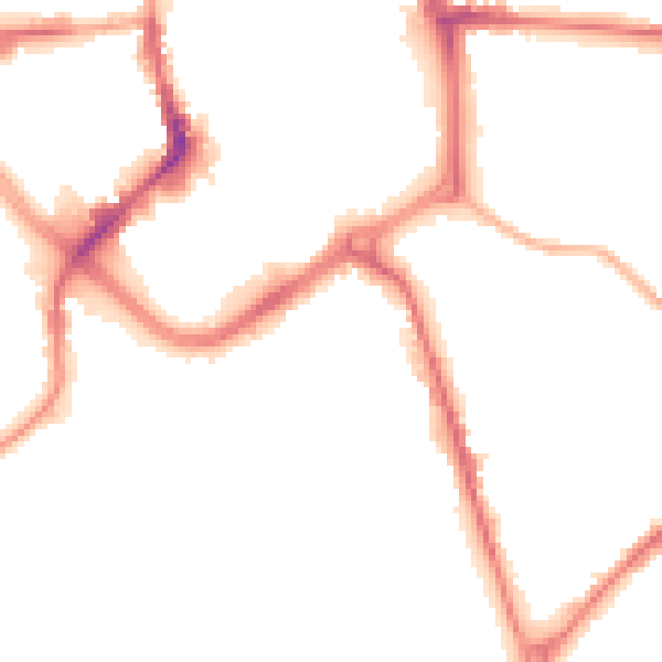
Night-time· 23:00 – 07:00
47.6dB