39 Shearman Road, Lewisham, London, SE3 9HY
About 39 Shearman Road
39 Shearman Road is a property in Lewisham, London, London (SE3 9HY). It has council tax band F.
2 planning records sit against the property, 2 approved, 0 refused. Past consents include tree works, meaningful when judging how the property has evolved.
Energy performance
No EPC on record
This property doesn't have an Energy Performance Certificate yet. An EPC is required to sell or let — and unlocks our automated valuation.
Planning history
Planning history at 39 Shearman Road is exclusively tree-management applications — typical for a property with mature trees on or near the plot.
- Aug 2011Tree WorksTreesIn report
Carry out work as detailed in the schedule to an Ash tree T107 at 39 Shearman Road, SE3.
- Agent
- Quality Tree Care Ltd
- Documents
- 1 doc on file
- Reference
- DC/11/077711/FT
- Aug 2011Tree WorksTreesIn report
Carry out work as detailed in the schedule to an Ash tree T107 at 39 Shearman Road, SE3.
- Agent
- Quality Tree Care Ltd
- Documents
- 1 doc on file
- Reference
- DC/11/77711/FT
Sales history & valuation
No sales recorded with HM Land Registry
That can mean the property has never traded since the registry began publishing in 1995, was a new build that hasn't been registered yet, or is held in the same hands long-term.
Median price across the last 5 sales in SE3 9HY: £785,000 (2024–2013).
Nearby sales in SE3 9HY
9 Shearman Road, Lewisham, London, SE3 9HY
Sold Sept 2024
£884,00023 Shearman Road, Lewisham, London, SE3 9HY
Sold Sept 2020
£772,00017 Shearman Road, Lewisham, London, SE3 9HY
Sold Aug 2018
£790,00037 Shearman Road, Lewisham, London, SE3 9HY
Sold May 2013
£780,0001 Shearman Road, Lewisham, London, SE3 9HY
Sold Sept 2008
£400,000
Similar properties nearby
1 Armstrong Close, Greenwich
SE3 9BT
1 Arne Walk, Lewisham
SE3 9HJ
1 Astell Road, Greenwich
SE3 9FB
1 Banks Road, Greenwich
SE3 9JS
1 Birdbrook Road, Greenwich
SE3 9QA
1 Blackheath Park, Greenwich
SE3 9RN
1 Boyd Way, Greenwich
SE3 9SD
1 Brooklands Park, Greenwich
SE3 9BN
The neighbourhood at a glance
Rail-style transport is unusually close for this postcode.
Crime
10/mo
Rising year-on-year across the wider district.
Nearest stop
0.1 km
Priory Park Blackheath — bus stop.
Closest school
0.3 km
St Margaret's Lee CofE Primary School. 61 schools nearby.
Road noise across the postcode
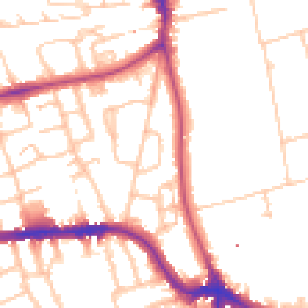
Daytime· 07:00 – 23:00
51.2dB
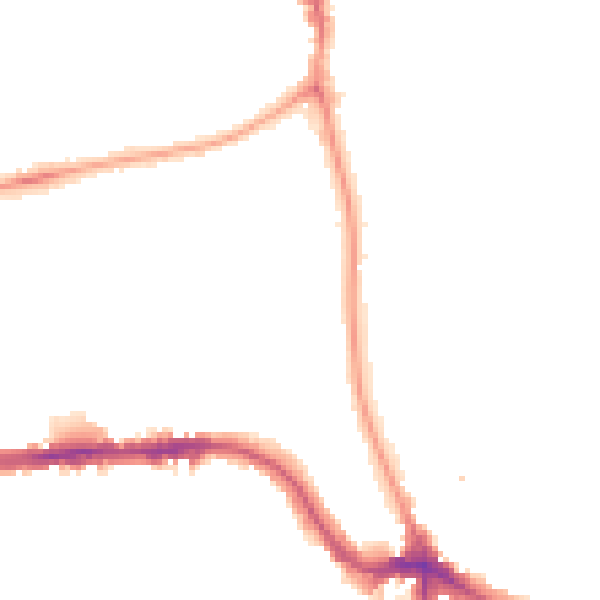
Night-time· 23:00 – 07:00
42.1dB