20 Berwick Way, Kettering, NN15 5XF
About 20 Berwick Way
20 Berwick Way is a four-bedroom detached house in Kettering (NN15 5XF). It has a recorded floor area of 131 m² (around 1410 sq ft), construction records dating it to 1983-1990 and council tax band E. The latest certificate (September 2015) shows a D (score 60), on the cusp of jumping into the C band. Earlier certificates rated it C (October 2008); the latest reading is one band lower. Between certificates, wall efficiency dropped from Good to Very Poor and roof efficiency dropped from Good to Average. The recommended improvements would lift it to B (score 82), a 2-band jump. The latest certificate is from September 2015, so improvements made since then won't be reflected. Records show the property has been extended at some point in its history.
Across 1997–2013, sale prices on this property compounded at 5.4% per year. Today's modelled estimate of £345,000 sits 62.7% above the 2013 sale of £212,000. 13 years since the last transfer (October 2013). Across the public record there are 5 sales, relatively high churn for a single property. One planning record on file: an extension approved in 2015. Past consents include an extension, meaningful when judging how the property has evolved.
What this property has
Inside
- Bedrooms4
- Dining roomYes
- Utility roomYes
- CloakroomYes
- EnsuiteYes
Outside
- Private gardenYes
- GarageSingle
Building
- Central heatingYes
- Previously extendedYes
Everything you need to know about 20 Berwick Way
The true value, the hidden risks and the full sale history, in one report.
Pick your report · every report is £14.99
One time fee only - money back guarantee

The data behind every report


Energy performance
20 Berwick Way's carbon output runs well above what efficient homes in the postcode produce.
EPC Expired
This certificate is over 10 years old and is no longer valid.Expired 10 Sept 2025
EPC Rating
Get a survey for this property
Level 3 Building Survey
Because the property has been extended more than once, we believe a Level 3 building survey should be considered.
From £955 · Includes VAT
Planning history
Council records include a part-single-part-two-storey extension at 20 Berwick Way.
1 application on record at 20 Berwick Way, Kettering, NN15 5XF
- Aug 2015ExtensionFullOutcome in report
Extension: Part single, part two storey
Single storey front and two storey rear extensions
- Documents
- 14 docs on file
- Reference
- KET/2015/0447
Unlock 20 Berwick Way, Kettering, NN15 5XF's full planning history
You're seeing the shape of it. The report has the substance.
- Every decision — granted, refused or withdrawn (1 on record)
- All 1 application on this property in full, plus 5 notable nearby
- The 14 documents, officer reports & conditions
- What the pattern means for extending or converting here
One time fee only - money back guarantee
Sales history & valuation
Sale price has at least doubled since 1997.
£345,000
Modelled from EPC, postcode comparables and a sale-price growth of 5.4% per year over 16 years.
£212,000
Growth on file: 5.4% per year over 16 years.
Sales timeline
30 October 2013Most recent
£212,000
+6.5%over 2 years15 September 2011
£199,000
-4.1%over 5 years27 July 2006
£207,500
+131.8%over 7 years29 September 1998
£89,500
-2.7%over 9 months22 December 1997
£91,995
Median price across the last 5 sales in NN15 5XF: £380,000 (2021–2019).
Nearby sales in NN15 5XF
Versus other Berwick Way homes
CO₂ Emissions for 20 Berwick Way lags the street by a wide margin.
Price per m²
£1,618
Street avg £2,018
Floor Area
131 m²
Street avg 127 m²
Habitable Rooms
8 rooms
Street avg 7 rooms
CO₂ Emissions
6.2 t/year
Street avg 4.8 t/year
Everything you need to know about 20 Berwick Way
The true value, the hidden risks and the full sale history, in one report.
Pick your report · every report is £14.99
One time fee only - money back guarantee
The data behind every report
Similar properties nearby
1 Ashby Close, Burton Latimer
NN15 5GN
1 Addis Close, Burton Latimer
NN15 5GL
1 Beardsley Gardens, Barton Seagrave
NN15 5UB
1 Blake Court, Barton Seagrave
NN15 5EU
1 Buckby Drive, Burton Latimer
NN15 5FU
1 Brands Hatch Close, Burton Latimer
NN15 5WF
1 Berwick Way
NN15 5XF
1 Baldwin Drive, Burton Latimer
NN15 5ZJ
The neighbourhood at a glance
Crime
2/mo
Steady year-on-year across the wider district.
Nearest stop
0.2 km
St Lukes Close — bus stop.
Closest school
0.5 km
Millbrook Infant School. 18 schools nearby.
Go deeper on the local area
A Local Area report breaks down crime, transport links, schools and air quality in depth.
Road noise across the postcode
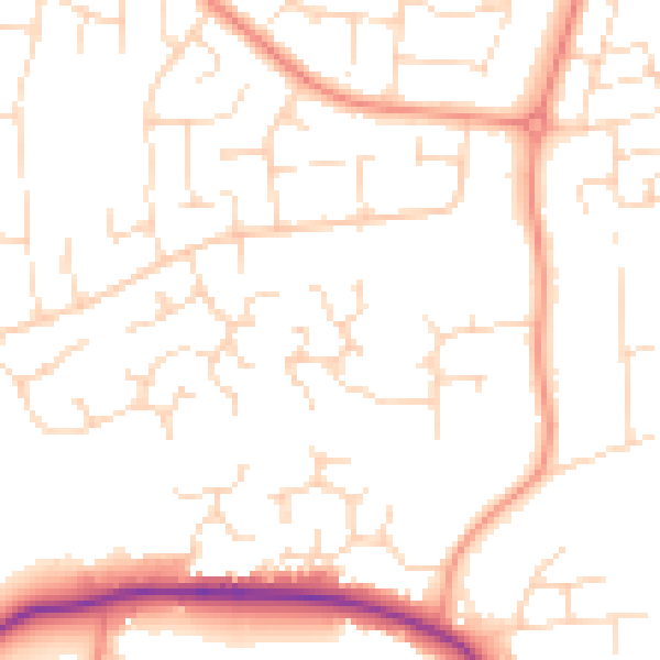
Daytime· 07:00 – 23:00
50.1dB

Night-time· 23:00 – 07:00
39.1dB