1 Clare Road, Sutton In Ashfield, NG17 5BB
About 1 Clare Road
1 Clare Road is a two-bedroom semi-detached house in Sutton In Ashfield (NG17 5BB). It has a recorded floor area of 72 m² (around 775 sq ft), construction records dating it to 1930-1949 and council tax band A. The latest certificate (April 2021) shows a D (score 62), on the cusp of jumping into the C band. When first surveyed in June 2009 the rating was F, the property has climbed 2 bands since. Between certificates, window efficiency went from Poor to Average, hot-water efficiency went from Poor to Good and lighting went from Very Poor to Average. The recommended improvements would lift it to B (score 84), a 2-band jump. Our model identifies extension potential, subject to local planning policy. The home occupies a corner plot.
At 72 m² the property is well over the postcode median (44 m² across 61 EPCs), placing it in the larger end of the local stock. Most recent transfer: June 2021 at £105,000. Across the public record there are 4 sales, relatively high churn for a single property. That sale was during the post-pandemic price surge, when transactions cleared materially above pre-2020 trend. 5 planning records sit against the property, 0 approved, 0 refused. Across 2001–2021, sale prices on this property compounded at 7.2% per year. Today's modelled estimate of £149,000 is 41.9% above the 2021 sale price.
Know exactly what you're buying at 1 Clare Road
Before you offer, see what the listing won't tell you, the true value, the red flags and the full history.
Already flagged here
Valuation
against the asking price
Risks
planning & flood
Sold prices
similar homes nearby
Trends
the local market
What this property has
Inside
- Bedrooms2
- Bathrooms1
Outside
- Corner plotYes
Building
- RefurbishedYes
- Extension potentialPossible
Energy performance
Recommended upgrades on file would lift this property by multiple EPC bands.
EPC Rating
Property Improvements
Changes detected from historical EPC data
Heating controls changed
Hot water system upgraded
Windows upgraded, improving insulation
Loft insulation upgraded to recommended levels
More low energy lighting installed
Planning history
- Mar 2026ApplicationIn report
Application for approval of details reserved by condition 12 - new road details , of planning permission v/2023/0417
- Documents
- 10 docs on file
- Reference
- V/2026/0154
- Mar 2026ApplicationIn report
Application to discharge condition 8 - construction management plan and condition 9 - finished floor levels, for planning permission v/2023/0417
- Documents
- 17 docs on file
- Reference
- V/2026/0143
We flagged 1 thing worth checking at 1 Clare Road
Independent checks surfaced things a buyer would want to understand before offering. The report explains each one in full, with the underlying data and what to ask.
- Larger development activity nearby
30-day money-back guarantee
Sales history & valuation
Latest sale on 1 Clare Road was the highest on Land Registry record across the postcode.
£149,000
Modelled from EPC, postcode comparables and a sale-price growth of 7.2% per year over 20 years.
£105,000
Growth on file: 7.2% per year over 20 years.
Sales timeline
22 June 2021Most recent
£105,000
+34.6%over 13 years6 September 2007
£78,000
+34.5%over 3 years12 February 2004
£58,000
+123.1%over 2 years1 July 2001
£26,000
Median price across the last 5 sales in NG17 5BB: £47,000 (2025–2022).
Nearby sales in NG17 5BB
54 Clare Road, Sutton In Ashfield, NG17 5BB
Sold Jul 2025
£47,00057 Clare Road, Sutton In Ashfield, NG17 5BB
Sold Jan 2025
£66,00030 Clare Road, Sutton In Ashfield, NG17 5BB
Sold Dec 2023
£39,99953 Clare Road, Sutton In Ashfield, NG17 5BB
Sold Oct 2022
£50,00042 Clare Road, Sutton In Ashfield, NG17 5BB
Sold May 2022
£45,000
Everything we know about 1 Clare Road, in one report
What it's really worth, what could be wrong, and the planning, sales and area data in full.
What we flagged
- Larger development activity nearby

Versus other Clare Road homes
On epc rating, 1 Clare Road runs well behind the street norm.
EPC Rating
62 (D)
Street avg 68 (D)
Floor Area
72 m²
Street avg 75 m²
CO₂ Emissions
3.9 t/year
Street avg 3.0 t/year
Habitable Rooms
4 rooms
Street avg 5 rooms
Similar properties nearby
The neighbourhood at a glance
Crime
5/mo
Steady year-on-year across the wider district.
Nearest stop
0.1 km
Barnes Crescent — bus stop.
Closest school
0.1 km
Leamington Primary and Nursery Academy. 19 schools nearby.
Go deeper on the local area
The full report breaks down crime, transport links, schools and air quality in depth.
Road noise across the postcode
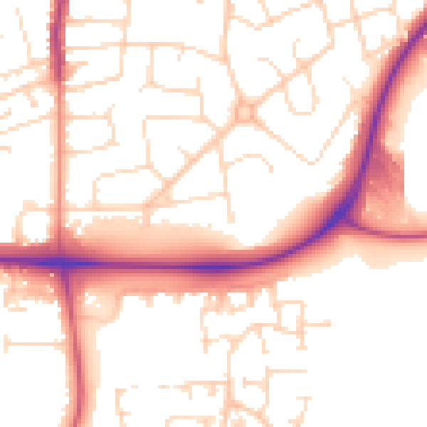
Daytime· 07:00 – 23:00
53.2dB

Night-time· 23:00 – 07:00
43.1dB