29 Churston Gardens, Haringey, London, N11 2NJ
About 29 Churston Gardens
29 Churston Gardens is a property in Haringey, London, London (N11 2NJ). It has council tax band E.
Untraded for 26 years, with the last transfer in June 2000. Only one transfer is on record with HM Land Registry, suggesting it has stayed in the same hands for a long time. One historical planning record sits against the property in 2012.
Everything you need to know about 29 Churston Gardens
The true value, the hidden risks and the full sale history, in one report.
30-day money-back guarantee

The data behind every report


Energy performance
No EPC on record
This property doesn't have an Energy Performance Certificate yet. An EPC is required to sell or let — and unlocks our automated valuation.
Planning history
- Apr 2012OutlineIn report
Certificate of Lawfulness for erection of rear dormer.
- Documents
- 7 docs on file
- Reference
- HGY/2012/0368
We flagged 2 things worth checking at 29 Churston Gardens
Independent checks surfaced things a buyer would want to understand before offering. The report explains each one in full, with the underlying data and what to ask.
- Signs of HMO activity in the area
- Larger development activity nearby
30-day money-back guarantee
Sales history & valuation
£211,000
Recorded with HM Land Registry.
Sales timeline
22 June 2000Most recent
£211,000
Median price across the last 5 sales in N11 2NJ: £850,000 (2025–2015).
Nearby sales in N11 2NJ
7 Churston Gardens, Haringey, London, N11 2NJ
Sold Feb 2025
£850,00031 Churston Gardens, Haringey, London, N11 2NJ
Sold Jul 2023
£980,00039 Churston Gardens, Haringey, London, N11 2NJ
Sold Feb 2019
£770,00025 Churston Gardens, Haringey, London, N11 2NJ
Sold Jun 2017
£878,8009 Churston Gardens, Haringey, London, N11 2NJ
Sold Mar 2015
£640,000
Everything you need to know about 29 Churston Gardens
The true value, the hidden risks and the full sale history, in one report.
30-day money-back guarantee
The data behind every report
Similar properties nearby
1 Amethyst Close, Haringey
N11 2LW
1 Bailey Close, Haringey
N11 2JL
1 Beech Road, Enfield
N11 2DA
1 Bexhill Road, Enfield
N11 2RG
1 Blake Road, Haringey
N11 2AD
1 Bosworth Road, Enfield
N11 2SY
1 Churston Gardens, Haringey
N11 2NJ
1 Durnsford Road, Haringey
N11 2EP
The neighbourhood at a glance
Rail-style transport is unusually close for this postcode.
Crime
5/mo
Rising year-on-year across the wider district.
Nearest stop
0.2 km
Cline Road — bus stop.
Closest school
0.0 km
St Martin of Porres Catholic Primary School. 61 schools nearby.
Go deeper on the local area
The full report breaks down crime, transport links, schools and air quality in depth.
Road noise across the postcode
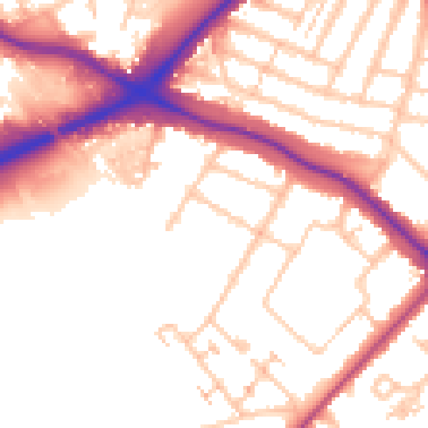
Daytime· 07:00 – 23:00
53.9dB

Night-time· 23:00 – 07:00
45.3dB