42 Abingdon Road, Urmston, Manchester, M41 0GN
About 42 Abingdon Road
42 Abingdon Road is a three-bedroom semi-detached house in Urmston, Manchester, Manchester (M41 0GN). It has a recorded floor area of 81 m² (around 872 sq ft), construction records dating it to 1930-1949 and council tax band C. The latest certificate (May 2021) shows an E (score 52), well below the UK norm with real room to improve. The recommended improvements would lift it to C (score 75), a 2-band jump. Other recorded features include a conservatory. Records show the property has been extended at some point in its history.
One planning record on file: an extension approved in 2022. Past consents include an extension, meaningful when judging how the property has evolved. It lags the bulk of the postcode on energy efficiency (less efficient than 81% of similar EPCs). Today's modelled estimate of £402,000 is 34% above the 2021 sale price. On a £-per-square-foot basis, the last sale (£344/sq ft) was about 56.9% above the typical sold price in the postcode. Last sale on file: £300,000 in November 2021. That sale was during the post-pandemic price surge, when transactions cleared materially above pre-2020 trend.
What this property has
Inside
- Bedrooms3
- Bathrooms1
- Dining roomYes
- CloakroomYes
- ConservatoryYes
Outside
- Private gardenSouth-facing
- GarageDetached
Building
- Previously extendedYes
Everything you need to know about 42 Abingdon Road
The true value, the hidden risks and the full sale history, in one report.
Pick your report · every report is £14.99
One time fee only - money back guarantee

The data behind every report


Energy performance
Recommended upgrades on file would lift this property by multiple EPC bands.
EPC Rating
Get a survey for this property
Level 2 HomeBuyer Report
We've checked 10 risk factors against the available data for this property and believe a Level 2 HomeBuyer Report could be a suitable option for you.
From £695 · Includes VAT
Planning history
42 Abingdon Road has an approved single-storey side and rear extension on the planning record.
1 application on record at 42 Abingdon Road, Urmston, Manchester, M41 0GN
- Mar 2022ExtensionFullOutcome in report
Extension: Single storey · Side and rear of property
Erection of single storey side, front and rear extension.
- Documents
- 8 docs on file
- Reference
- 106681/HHA/21
Unlock 42 Abingdon Road, Urmston, Manchester, M41 0GN's full planning history
You're seeing the shape of it. The report has the substance.
- Every decision — granted, refused or withdrawn (1 on record)
- All 1 application on this property in full, plus 3 notable nearby
- The 8 documents, officer reports & conditions
- What the pattern means for extending or converting here
One time fee only - money back guarantee
Sales history & valuation
The latest sale landed in the post-pandemic price surge — useful context when reading the figure.
£402,000
Modelled from EPC, postcode comparables.
£300,000
Recorded with HM Land Registry.
Sales timeline
12 November 2021Most recent
£300,000
Median price across the last 5 sales in M41 0GN: £365,000 (2024–2021).
Nearby sales in M41 0GN
56 Abingdon Road, Urmston, Manchester, M41 0GN
Sold May 2024
£365,00020 Abingdon Road, Urmston, Manchester, M41 0GN
Sold Dec 2022
£390,00024 Abingdon Road, Urmston, Manchester, M41 0GN
Sold Sept 2021
£365,00044 Abingdon Road, Urmston, Manchester, M41 0GN
Sold May 2021
£269,00048 Abingdon Road, Urmston, Manchester, M41 0GN
Sold Mar 2021
£320,000
Versus other Abingdon Road homes
On years held, 42 Abingdon Road runs well behind the street norm.
Price per m²
£3,704
Street avg £3,122
Floor Area
81 m²
Street avg 94 m²
Habitable Rooms
5 rooms
Street avg 5 rooms
CO₂ Emissions
5.0 t/year
Street avg 4.2 t/year
Everything you need to know about 42 Abingdon Road
The true value, the hidden risks and the full sale history, in one report.
Pick your report · every report is £14.99
One time fee only - money back guarantee
The data behind every report
Similar properties nearby
1 Chislehurst Avenue, Urmston
M41 0SG
1 Dorchester Avenue, Urmston
M41 0QJ
1 Chester Avenue, Urmston
M41 0ZH
1 Hartford Road, Urmston
M41 0RZ
1 Furness Road, Urmston
M41 0UQ
1 Ellaston Drive, Urmston
M41 0XB
1 Derby Road, Urmston
M41 0UF
1 Exeter Road, Urmston
M41 0RF
The neighbourhood at a glance
Crime
1/mo
Steady year-on-year across the wider district.
Nearest stop
0.1 km
Wallingford Road — bus stop.
Closest school
0.3 km
St Hugh of Lincoln RC Primary School. 28 schools nearby.
Go deeper on the local area
A Local Area report breaks down crime, transport links, schools and air quality in depth.
Road noise across the postcode
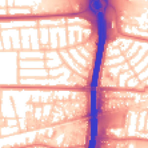
Daytime· 07:00 – 23:00
58.6dB
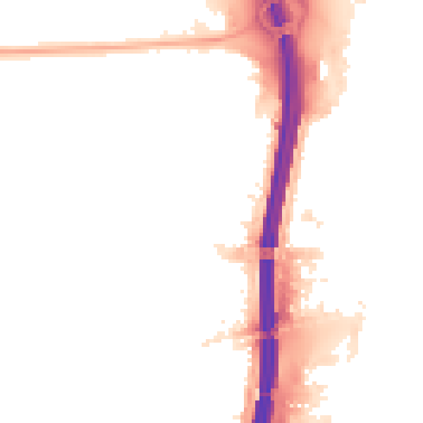
Night-time· 23:00 – 07:00
50.3dB