1 Dene Drive, Middleton, Manchester, M24 1QY
About 1 Dene Drive
1 Dene Drive is a four-bedroom detached house in Middleton, Manchester, Manchester (M24 1QY). It has a recorded floor area of 140 m² (around 1507 sq ft), construction records dating it to 1967-1975 and council tax band C. The latest certificate (May 2020) shows a D (score 68), on the cusp of jumping into the C band. Earlier certificates rated it C (November 2012); the latest reading is one band lower. Between certificates, lighting went from Good to Very Good; while wall efficiency dropped from Good to Average. The recommended improvements would push it to C (score 78).
It hasn't traded since May 1996, a hold of 30 years that's notably long for the area. Only one transfer is on record with HM Land Registry, suggesting it has stayed in the same hands for a long time. Today's modelled estimate of £376,000 sits 616.2% above the 1996 sale of £52,500. One planning record on file: an extension approved in 2007. Past consents include an extension, meaningful when judging how the property has evolved.
What this property has
Inside
- Bedrooms4
- FireplaceYes
Outside
- Private gardenYes
- GarageYes
Building
- Central heatingYes
Everything you need to know about 1 Dene Drive
The true value, the hidden risks and the full sale history, in one report.
Pick your report · every report is £14.99
One time fee only - money back guarantee

The data behind every report


Energy performance
EPC Rating
Property Improvements
Changes detected from historical EPC data
Heating controls upgraded for better temperature management
More low energy lighting installed
Get a survey for this property
Level 2 HomeBuyer Report
We've checked 10 risk factors against the available data for this property and believe a Level 2 HomeBuyer Report could be a suitable option for you.
From £595 · Includes VAT
Planning history
1 Dene Drive has an approved side and rear extension on the planning record.
1 application on record at 1 Dene Drive, Middleton, Manchester, M24 1QY
- May 2007ExtensionFullOutcome in report
Extension: Side and rear of property
Two Storey Side And Single Storey Rear Extension To Dwelling
- Documents
- 1 doc on file
- Reference
- 07/D49052
Unlock 1 Dene Drive, Middleton, Manchester, M24 1QY's full planning history
You're seeing the shape of it. The report has the substance.
- Every decision — granted, refused or withdrawn (1 on record)
- All 1 application on this property in full, plus 5 notable nearby
- The 1 documents, officer reports & conditions
- What the pattern means for extending or converting here
One time fee only - money back guarantee
Sales history & valuation
1 Dene Drive's modelled value sits at over four times its earliest registered sale price (1996).
£376,000
Modelled from EPC, postcode comparables.
£52,500
Recorded with HM Land Registry.
Sales timeline
2 May 1996Most recent
£52,500
Median price across the last 2 sales in M24 1QY: £342,500 (2021–2013).
Nearby sales in M24 1QY
Everything you need to know about 1 Dene Drive
The true value, the hidden risks and the full sale history, in one report.
Pick your report · every report is £14.99
One time fee only - money back guarantee
The data behind every report
Similar properties nearby
1 Brookbank Close, Middleton
M24 1FH
1 Dingle Road, Middleton
M24 1WF
1 Cheltenham Green, Middleton
M24 1HQ
1 Arden Avenue, Middleton
M24 1PN
1 Alresford Road, Middleton
M24 1WU
1 Banbury Road, Middleton
M24 1QB
1 Colwyn Avenue, Middleton
M24 1ER
1 Birch Avenue, Middleton
M24 1DR
The neighbourhood at a glance
Crime
1/mo
Steady year-on-year across the wider district.
Nearest stop
0.1 km
Alkrington Hall Road North — bus stop.
Closest school
0.6 km
Alkrington Primary School. 32 schools nearby.
Go deeper on the local area
A Local Area report breaks down crime, transport links, schools and air quality in depth.
Road noise across the postcode
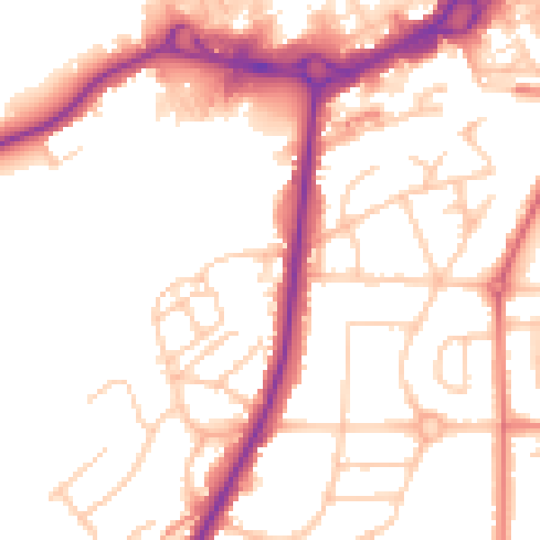
Daytime· 07:00 – 23:00
53.1dB

Night-time· 23:00 – 07:00
44.1dB