28 Albany Avenue, Manchester, M11 1HQ
About 28 Albany Avenue
28 Albany Avenue is a four-bedroom semi-detached house in Manchester (M11 1HQ). It has a recorded floor area of 94 m² (around 1012 sq ft), construction records dating it to 1930-1949 and council tax band B. The latest certificate (November 2016) shows a D (score 65), on the cusp of jumping into the C band. The rating has held steady at D across 2 certificates since November 2011. The recommended improvements would push it to C (score 78). Other recorded features include a conservatory. Records show the property has been extended at some point in its history. The home occupies a corner plot.
At 94 m² it's 19% larger than the typical home in the postcode (79 m² median across 17 EPCs). Across 1997–2023, sale prices on this property compounded at 9.9% per year. Today's modelled estimate of £311,000 is 13.1% above the 2023 sale price. On a £-per-square-foot basis, the last sale (£272/sq ft) was about 126.1% above the typical sold price in the postcode. Most recent transfer: December 2023 at £275,000.
Know exactly what you're buying at 28 Albany Avenue
Before you offer, see what the listing won't tell you, the true value, the red flags and the full history.
Valuation
against the asking price
Risks
planning & flood
Sold prices
similar homes nearby
Trends
the local market
What this property has
Inside
- Bedrooms4
- Bathrooms2
- Dining roomYes
- ConservatoryYes
Outside
- DrivewayYes
- Corner plotYes
Building
- Previously extendedYes
Energy performance
EPC Rating
Planning history
28 Albany Avenue has no planning applications on record.
Notable planning nearby
3applications of note in the surrounding area
Sales history & valuation
Latest sale on 28 Albany Avenue was the highest on Land Registry record across the postcode.
£311,000
Modelled from EPC, postcode comparables and a sale-price growth of 9.9% per year over 27 years.
£275,000
Growth on file: 9.9% per year over 27 years.
Sales timeline
1 December 2023Most recent
£275,000
+1152.8%over 26 years6 February 1997
£21,950
Median price across the last 5 sales in M11 1HQ: £181,000 (2023–2020).
Nearby sales in M11 1HQ
Everything we know about 28 Albany Avenue, in one report
What it's really worth, what could be wrong, and the planning, sales and area data in full.
- Am I paying too much?
- Is something wrong with it?
- Is the agent's story true?
- Will it hold its value?

Versus other Albany Avenue homes
On price per m², 28 Albany Avenue stands well clear of the street.
Price per m²
£2,926
Street avg £1,500
Floor Area
94 m²
Street avg 82 m²
Habitable Rooms
7 rooms
Street avg 5 rooms
CO₂ Emissions
3.9 t/year
Street avg 5.2 t/year
Similar properties nearby
The neighbourhood at a glance
Rail-style transport is unusually close for this postcode.
Nearest stop
0.1 km
Ashbrook Street — bus stop.
Closest school
0.4 km
Fairfield High School for Girls. 44 schools nearby.
Go deeper on the local area
The full report breaks down crime, transport links, schools and air quality in depth.
Road noise across the postcode
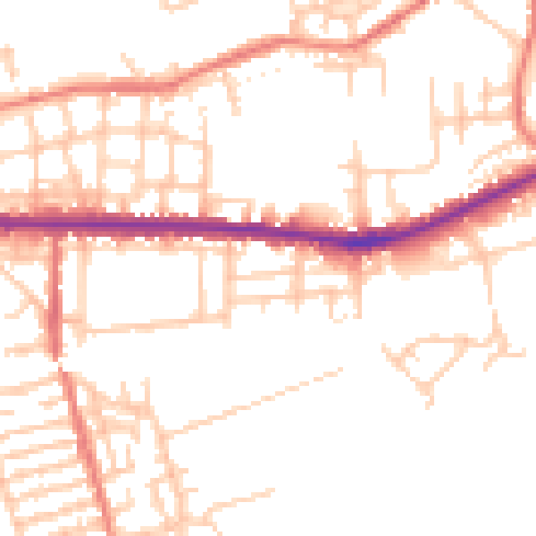
Daytime· 07:00 – 23:00
51.4dB

Night-time· 23:00 – 07:00
41.6dB