7 Austen Walk, Lincoln, LN2 4LP
About 7 Austen Walk
7 Austen Walk is a three-bedroom mid-terrace house in Lincoln (LN2 4LP). It has a recorded floor area of 81 m² (around 872 sq ft), construction records dating it to 1900-1929 and council tax band A. The latest certificate (August 2019) shows a D (score 67), on the cusp of jumping into the C band. The recommended improvements would lift it to B (score 90), a 2-band jump.
Across 2008–2014, sale prices on this property compounded at 1% per year. Today's modelled estimate of £180,000 sits 76.5% above the 2014 sale of £102,000. On a £-per-square-foot basis, the last sale (£117/sq ft) was about 35% above the typical sold price in the postcode. Last sold in October 2014, so it's been off the market for around 12 years.
What this property has
Inside
- Bedrooms3
- Bathrooms1
- Dining roomYes
Outside
- Private gardenRear
- DrivewayYes
Building
- Heating systemGas
- RefurbishedYes
Everything you need to know about 7 Austen Walk
The true value, the hidden risks and the full sale history, in one report.
Pick your report · every report is £14.99
One time fee only - money back guarantee

The data behind every report


Energy performance
Recommended upgrades on file would lift this property by multiple EPC bands.
EPC Rating
Get a survey for this property
Level 3 Building Survey
Because the property was built before 1919 and has solid (non-cavity) walls, we believe a Level 3 building survey should be considered.
From £820 · Includes VAT
Planning history
7 Austen Walk has no planning applications on record.
But the area is active
6 notable applications nearby — larger schemes and conversions that could reshape the street. The report maps them all.
Sales history & valuation
7 Austen Walk saw 3 transfers in just over a decade — high turnover for the postcode.
£180,000
Modelled from EPC, postcode comparables and a sale-price growth of 1.0% per year over 6 years.
£102,000
Growth on file: 1.0% per year over 6 years.
Sales timeline
12 October 2014Most recent
£102,000
+8.5%over 2 years1 May 2012
£94,000
-2.1%over 3 years19 May 2008
£96,000
Median price across the last 5 sales in LN2 4LP: £83,000 (2015–2009).
Versus other Austen Walk homes
On floor area, 7 Austen Walk runs well behind the street norm.
Price per m²
£1,259
Street avg £1,118
Floor Area
81 m²
Street avg 86 m²
Habitable Rooms
5 rooms
Street avg 5 rooms
CO₂ Emissions
3.4 t/year
Street avg 3.7 t/year
Everything you need to know about 7 Austen Walk
The true value, the hidden risks and the full sale history, in one report.
Pick your report · every report is £14.99
One time fee only - money back guarantee
The data behind every report
Similar properties nearby
The neighbourhood at a glance
Crime
3/mo
Steady year-on-year across the wider district.
Nearest stop
0.1 km
Austen Walk — bus stop.
Closest school
0.2 km
St Giles Academy. 15 schools nearby.
Go deeper on the local area
A Local Area report breaks down crime, transport links, schools and air quality in depth.
Road noise across the postcode
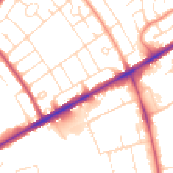
Daytime· 07:00 – 23:00
52.3dB

Night-time· 23:00 – 07:00
41.7dB