53a, Markfield Road, Groby, Leicester, LE6 0FL
About 53a
53a is a three-bedroom property in Groby, Leicester, Leicester (LE6 0FL). It has council tax band B. Other recorded features include a conservatory and attached land beyond the plot.
2 planning records sit against the property, 1 approved, 0 refused. Past consents include tree works, meaningful when judging how the property has evolved. On the market in March 2016 and unlisted since — roughly 10 years. Across 2001–2016, sale prices on this property compounded at 4.4% per year.
What this property has
Inside
- Bedrooms3
- Bathrooms2
- EnsuiteYes
- ConservatoryYes
Outside
- Private gardenYes
- GarageDouble
- LandYes
Everything you need to know about 53a
The true value, the hidden risks and the full sale history, in one report.
30-day money-back guarantee

The data behind every report


Energy performance
No EPC on record
This property doesn't have an Energy Performance Certificate yet. An EPC is required to sell or let — and unlocks our automated valuation.
Planning history
Planning history at 53a is exclusively tree-management applications — typical for a property with mature trees on or near the plot.
- Feb 2025Tree WorksTreesIn report
T022 – Ash- reduce south facing branch by 4-5m T023 – Ash- reduce to 3-4m standing monolith T027 – Ash – Fell T028 – Ash – Fell T030 – Ash – Crown reduce by 3m T031 – Ash – reduce to 3-4m standing monolith T032 – Ash – Crown reduce by 3-4m T033 – Ash -fell
- Council
- 24/01021/TPO
- Documents
- 25 docs on file
- Reference
- 2025/TPO/0005/LCC
- Dec 2020Tree WorksTreesIn report
to reduce branches of a group of ash G1 overhanging the garage by 2.0m, remove a low branch overhanging garage and remove dead wood) protected by Leicestershire County Council Groby (Markfield Road) Tree Preservation Order 1972
- Documents
- 4 docs on file
- Reference
- 20/01228/CTPO
What's in 53a, Markfield Road, Groby, Leicester, LE6 0FL's planning history?
Refusals, disputes and full decisions on this property and nearby, in the report.
Sales history & valuation
£360,000
Growth on file: 4.4% per year over 14 years.
Sales timeline
18 March 2016Most recent
£360,000
+87.0%over 14 years17 October 2001
£192,500
Median price across the last 5 sales in LE6 0FL: £325,000 (2025–2021).
Nearby sales in LE6 0FL
71 Markfield Road, Groby, Leicester, LE6 0FL
Sold Mar 2025
£325,00073 Markfield Road, Groby, Leicester, LE6 0FL
Sold Jun 2024
£178,00069 Markfield Road, Groby, Leicester, LE6 0FL
Sold Aug 2023
£315,00045 Markfield Road, Groby, Leicester, LE6 0FL
Sold Dec 2021
£400,00043 Markfield Road, Groby, Leicester, LE6 0FL
Sold Mar 2021
£390,000
Everything you need to know about 53a
The true value, the hidden risks and the full sale history, in one report.
30-day money-back guarantee
The data behind every report
Similar properties nearby
1 Brook Drive, Ratby
LE6 0AQ
1 Castle Rise, Groby
LE6 0YQ
1 Ash Court, Groby
LE6 0EH
1 Bumblebee Close, Ratby
LE6 0PB
1 Cedar Court, Groby
LE6 0ET
1 Castell Drive, Groby
LE6 0DE
1 Astill Close, Ratby
LE6 0SA
1 Buttercup Grove, Ratby
LE6 0PE
The neighbourhood at a glance
Crime
2/mo
Steady year-on-year across the wider district.
Nearest stop
0.2 km
A50 Junction — bus stop.
Closest school
0.3 km
Martinshaw Primary School. 8 schools nearby.
Go deeper on the local area
The full report breaks down crime, transport links, schools and air quality in depth.
Road noise across the postcode
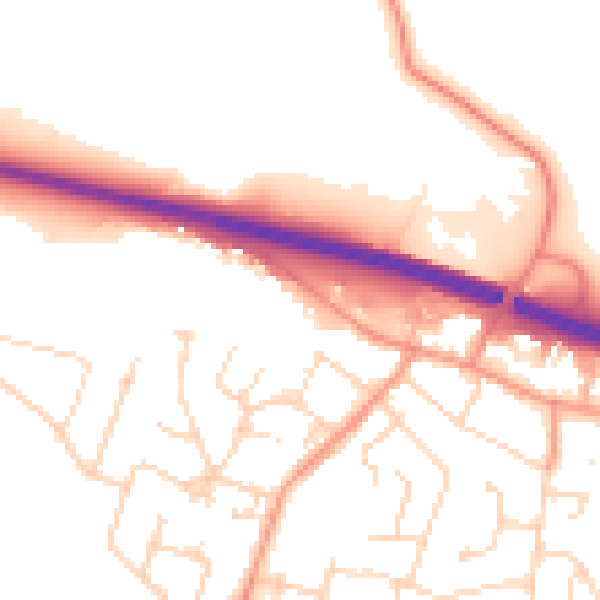
Daytime· 07:00 – 23:00
52.7dB

Night-time· 23:00 – 07:00
43.2dB