71 Markfield Road, Groby, Leicester, LE6 0FL
About 71 Markfield Road
71 Markfield Road is a four-bedroom semi-detached house in Groby, Leicester, Leicester (LE6 0FL). It has a recorded floor area of 112 m² (around 1206 sq ft), construction records dating it to 1900-1929 and council tax band C. The latest certificate (February 2023) shows a D (score 66), on the cusp of jumping into the C band. The recommended improvements would lift it to B (score 82), a 2-band jump. Other recorded features include attached land beyond the plot.
Most recent transfer was March 2025 at £325,000 — fresh data. At 112 m² it's 25.5% larger than the typical home in the postcode (89 m² median across 29 EPCs). Across 1999–2025, sale prices on this property compounded at 7.2% per year. On a £-per-square-foot basis, the last sale (£270/sq ft) was about 28.4% above the typical sold price in the postcode.
What this property has
Inside
- Bedrooms4
- Bathrooms2
- EnsuiteYes
Outside
- GarageDouble
- LandYes
Everything you need to know about 71 Markfield Road
The true value, the hidden risks and the full sale history, in one report.
30-day money-back guarantee

The data behind every report


Energy performance
Recommended upgrades on file would lift this property by multiple EPC bands.
EPC Rating
Planning history
71 Markfield Road has no planning applications on record.
The full report still covers planning activity across the surrounding area.
Sales history & valuation
Price for 71 Markfield Road has grown more than fourfold since the 1999 starting point.
£354,000
Modelled from EPC, postcode comparables and a sale-price growth of 7.2% per year over 26 years.
£325,000
Growth on file: 7.2% per year over 26 years.
Sales timeline
21 March 2025Most recent
£325,000
+501.9%over 25 years29 July 1999
£54,000
Median price across the last 5 sales in LE6 0FL: £315,000 (2024–2021).
Nearby sales in LE6 0FL
73 Markfield Road, Groby, Leicester, LE6 0FL
Sold Jun 2024
£178,00069 Markfield Road, Groby, Leicester, LE6 0FL
Sold Aug 2023
£315,00045 Markfield Road, Groby, Leicester, LE6 0FL
Sold Dec 2021
£400,00043 Markfield Road, Groby, Leicester, LE6 0FL
Sold Mar 2021
£390,0009 Markfield Road, Groby, Leicester, LE6 0FL
Sold Feb 2021
£147,000
Versus other Markfield Road homes
On years held, 71 Markfield Road runs well behind the street norm.
Price per m²
£2,902
Street avg £2,511
Floor Area
112 m²
Street avg 123 m²
Habitable Rooms
6 rooms
Street avg 5 rooms
CO₂ Emissions
4.1 t/year
Street avg 7.6 t/year
Everything you need to know about 71 Markfield Road
The true value, the hidden risks and the full sale history, in one report.
30-day money-back guarantee
The data behind every report
Similar properties nearby
1 Astill Close, Ratby
LE6 0SA
1 Buttercup Grove, Ratby
LE6 0PE
1 Buckingham Close, Groby
LE6 0YX
1 Bluebell Drive, Groby
LE6 0AX
1 Butler Close, Ratby
LE6 0GD
1 Brook Drive, Ratby
LE6 0AQ
1 Castle Rise, Groby
LE6 0YQ
1 Ash Court, Groby
LE6 0EH
The neighbourhood at a glance
Crime
2/mo
Steady year-on-year across the wider district.
Nearest stop
0.2 km
A50 Junction — bus stop.
Closest school
0.3 km
Martinshaw Primary School. 8 schools nearby.
Go deeper on the local area
The full report breaks down crime, transport links, schools and air quality in depth.
Road noise across the postcode
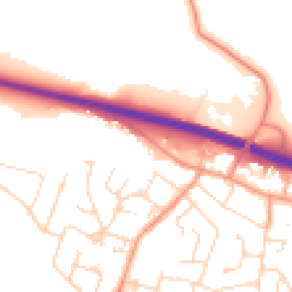
Daytime· 07:00 – 23:00
52.7dB

Night-time· 23:00 – 07:00
43.2dB