1 Holmfield Avenue, Leicester, LE2 2BG
About 1 Holmfield Avenue
1 Holmfield Avenue is a detached house in Leicester (LE2 2BG). It has a recorded floor area of 154 m² (around 1658 sq ft), construction records dating it to 2025 and council tax band F. The latest certificate (September 2025) returns an A (score 100), the top energy band on the EPC scale. When first surveyed in April 2016 the rating was E, the property has climbed 4 bands since. Between certificates, wall efficiency went from Very Poor to Very Good, roof efficiency went from Very Poor to Very Good and window efficiency went from Average to Good.
Untraded for 25 years, with the last transfer in July 2001. Only one transfer is on record with HM Land Registry, suggesting it has stayed in the same hands for a long time. At 154 m² the property is well over the postcode median (100 m² across 20 EPCs), placing it in the larger end of the local stock. On energy efficiency it sits in the top 10% of properties in this postcode. Today's modelled estimate of £616,000 sits 180% above the 2001 sale of £220,000. On a £-per-square-foot basis, the last sale (£133/sq ft) was about 29.5% below the postcode norm. 3 planning records sit against the property, 2 approved, 1 refused.
Everything you need to know about 1 Holmfield Avenue
The true value, the hidden risks and the full sale history, in one report.
Pick your report · from £14.99
One time fee only - money back guarantee

The data behind every report







Energy performance
1 Holmfield Avenue ranks among the most efficient homes in the postcode for energy use.
EPC Rating
Certificate validity
Valid until 9 September 2035
Property Improvements
Changes detected from historical EPC data
Heating controls upgraded for better temperature management
Hot water system upgraded
High performance glazing installed
Cavity wall insulation installed
Loft insulation installed or upgraded to 250mm+
Floor insulation added or improved
More low energy lighting installed

Get a survey for this property
Snagging Report
Because the property was built within the last two years, we believe a snagging report is more appropriate for this property than a home survey.
Planning history
A recent planning application at 1 Holmfield Avenue was refused — worth checking the council file.
3 applications on record at 1 Holmfield Avenue, Leicester, LE2 2BG
- Jan 2022FullOutcome in report
Demolition of existing garage; construction of 1.5 storey bungalow (1x2 bed) (Class C3)
- Documents
- 8 docs on file
- Reference
- 20211839
- More recent applications — locked
- OutbuildingMar 2025Decision
- ConditionsFeb 2024Decision
Unlock 1 Holmfield Avenue, Leicester, LE2 2BG's full planning history
You're seeing the shape of it. The report has the substance.
- Every decision — granted, refused or withdrawn (3 on record)
- All 3 applications on this property in full, plus 3 notable nearby
- The 16 documents, officer reports & conditions
- What the pattern means for extending or converting here
One time fee only - money back guarantee
Sales history & valuation
1 Holmfield Avenue valuation sits well clear of the typical sold price in this postcode.
£616,000
Modelled from EPC, postcode comparables.
£220,000
Recorded with HM Land Registry.
Sales timeline
11 July 2001Most recent
£220,000
Median price across the last 5 sales in LE2 2BG: £343,000 (2025–2021).
Nearby sales in LE2 2BG
39 Holmfield Avenue, Leicester, LE2 2BG
Sold Sept 2025
£343,00037 Holmfield Avenue, Leicester, LE2 2BG
Sold Sept 2024
£335,00017 Holmfield Avenue, Leicester, LE2 2BG
Sold Mar 2022
£550,00015 Holmfield Avenue, Leicester, LE2 2BG
Sold Jun 2021
£550,00051 Holmfield Avenue, Leicester, LE2 2BG
Sold Feb 2021
£265,000
Versus other Holmfield Avenue homes
On epc rating, 1 Holmfield Avenue stands well clear of the street.
Price per m²
£1,429
Street avg £2,405
Floor Area
154 m²
Street avg 147 m²
CO₂ Emissions
1.2 t/year
Street avg 6.1 t/year
Years Held
25 years
Street avg 13 years
Everything you need to know about 1 Holmfield Avenue
The true value, the hidden risks and the full sale history, in one report.
Pick your report · from £14.99
One time fee only - money back guarantee
The data behind every report
Similar properties nearby
1 Bankart Avenue
LE2 2DD
1 Main Street, Little Stretton
LE2 2FS
1 Albert Road
LE2 2AA
1 Dovedale Road
LE2 2DN
1 Malvern Road
LE2 2BH
1 Glebe Gardens
LE2 2LQ
1 Knighton Rise
LE2 2RF
1 Cornfields, Little Stretton
LE2 2EY
The neighbourhood at a glance
Crime
910/mo
Falling year-on-year across the wider district.
Nearest stop
0.3 km
Byway Road — bus stop.
Closest school
0.7 km
St John the Baptist CofE Primary School. 43 schools nearby.
Go deeper on the local area
A Local Area report breaks down crime, transport links, schools and air quality in depth.
Road noise across the postcode
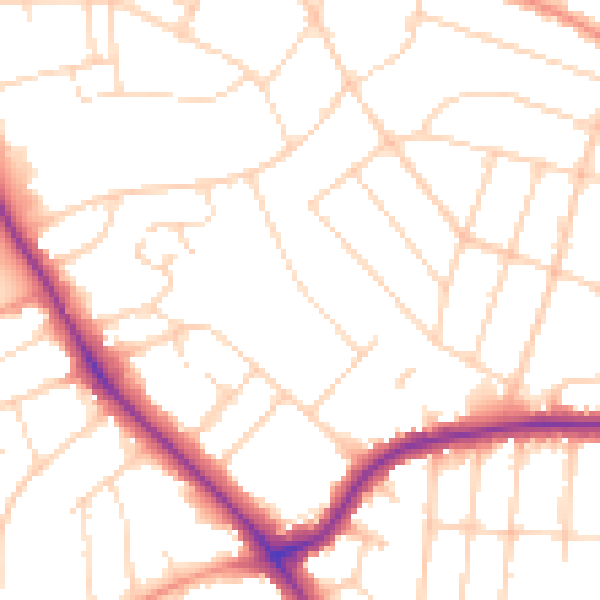
Daytime· 07:00 – 23:00
50.2dB

Night-time· 23:00 – 07:00
40.4dB