11 Rawson Street, Leicester, LE1 6UP
About 11 Rawson Street
11 Rawson Street is a mid-terrace house in Leicester (LE1 6UP). It has a recorded floor area of 85 m² (around 915 sq ft), construction records dating it to 1900-1929 and council tax band A. The latest certificate (January 2018) shows a D (score 58), a step below the typical UK home. The recommended improvements would lift it to B (score 84), a 2-band jump.
Last changed hands 11 years ago, in May 2015. Across 2007–2015, sale prices on this property compounded at 4.8% per year. Today's modelled estimate of £162,000 is 29.6% above the 2015 sale price.
Everything you need to know about 11 Rawson Street
The true value, the hidden risks and the full sale history, in one report.
Pick your report · every report is £14.99
One time fee only - money back guarantee

The data behind every report


Energy performance
Recommended upgrades on file would lift this property by multiple EPC bands.
EPC Rating
Get a survey for this property
Level 3 Building Survey
Because the property was built before 1919 and has solid (non-cavity) walls, we believe a Level 3 building survey should be considered.
From £820 · Includes VAT
Planning history
11 Rawson Street has no planning applications on record.
But the area is active
4 notable applications nearby — larger schemes and conversions that could reshape the street. The report maps them all.
Sales history & valuation
£162,000
Modelled from EPC, postcode comparables and a sale-price growth of 4.8% per year over 8 years.
£125,000
Growth on file: 4.8% per year over 8 years.
Sales timeline
6 May 2015Most recent
£125,000
+45.3%over 8 years29 April 2007
£86,000
Median price across the last 5 sales in LE1 6UP: £130,000 (2022–2009).
Nearby sales in LE1 6UP
Versus other Rawson Street homes
On price per m², 11 Rawson Street runs well behind the street norm.
Price per m²
£1,471
Street avg £1,835
Floor Area
85 m²
Street avg 85 m²
Habitable Rooms
4 rooms
Street avg 4 rooms
CO₂ Emissions
4.8 t/year
Street avg 4.2 t/year
Everything you need to know about 11 Rawson Street
The true value, the hidden risks and the full sale history, in one report.
Pick your report · every report is £14.99
One time fee only - money back guarantee
The data behind every report
Similar properties nearby
12 Bowling Green Street
LE1 6AT
11 Eastgate Apartments, East Street
LE1 6NB
1 Regent Road
LE1 6YE
10 Eastgate Apartments, East Street
LE1 6NB
101 Granby Street
LE1 6FD
13 Rawson Street
LE1 6UP
12 Eastgate Apartments, East Street
LE1 6NB
1 Eastgate Apartments, East Street
LE1 6NB
The neighbourhood at a glance
Rail-style transport is unusually close for this postcode.
Crime
13/mo
Rising year-on-year across the wider district.
Nearest stop
0.2 km
Tower Street — bus stop.
Closest school
0.3 km
Beauchamp City Sixth Form. 51 schools nearby.
Go deeper on the local area
A Local Area report breaks down crime, transport links, schools and air quality in depth.
Road noise across the postcode
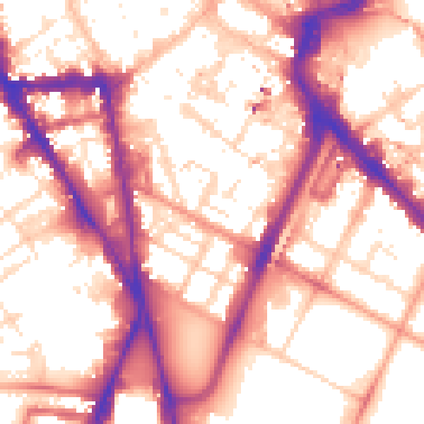
Daytime· 07:00 – 23:00
57.2dB

Night-time· 23:00 – 07:00
47.6dB