29 Lowden Avenue, Liverpool, L21 9JE
About 29 Lowden Avenue
29 Lowden Avenue is a semi-detached house in Liverpool (L21 9JE). It has a recorded floor area of 85 m² (around 915 sq ft), construction records dating it to 1930-1949 and council tax band B. The latest certificate (November 2022) shows a C (score 72). When first surveyed in February 2014 the rating was E, the property has climbed 2 bands since. Between certificates, wall efficiency went from Poor to Good, roof efficiency went from Very Poor to Good and lighting went from Good to Very Good. The recommended improvements would push it to B (score 85).
Held since July 2006 — that's 20 years off the open market, well above the local norm. At 85 m² it's 18.1% larger than the typical home in the postcode (72 m² median across 11 EPCs). Across 1999–2006, sale prices on this property compounded at 17.5% per year. Today's modelled estimate of £191,000 is 27.4% above the 2006 sale price.
Everything you need to know about 29 Lowden Avenue
The true value, the hidden risks and the full sale history, in one report.
30-day money-back guarantee

The data behind every report


Energy performance
EPC Rating
Property Improvements
Changes detected from historical EPC data
Heating controls upgraded for better temperature management
Wall insulation improved
Loft insulation installed or upgraded to 250mm+
More low energy lighting installed
Planning history
29 Lowden Avenue has no planning applications on record.
Notable planning nearby
1applications of note in the surrounding area
Sales history & valuation
29 Lowden Avenue has more than tripled in price since its earliest registered sale in 1999.
£191,000
Modelled from EPC, postcode comparables and a sale-price growth of 17.5% per year over 7 years.
£149,950
Growth on file: 17.5% per year over 7 years.
Sales timeline
4 July 2006Most recent
£149,950
+220.7%over 7 years13 April 1999
£46,750
Median price across the last 5 sales in L21 9JE: £164,000 (2024–2021).
Nearby sales in L21 9JE
Versus other Lowden Avenue homes
On years held, 29 Lowden Avenue stands well clear of the street.
Price per m²
£1,764
Street avg £1,913
Floor Area
85 m²
Street avg 77 m²
Habitable Rooms
5 rooms
Street avg 5 rooms
CO₂ Emissions
2.6 t/year
Street avg 3.7 t/year
Everything you need to know about 29 Lowden Avenue
The true value, the hidden risks and the full sale history, in one report.
30-day money-back guarantee
The data behind every report
Similar properties nearby
1 Caledonian Crescent
L21 9QA
1 Caldon Close
L21 9PZ
1 Eltham Avenue
L21 9LL
1 Delph Court, Field Lane, Litherland
L21 9PJ
1 Newlyn Avenue, Litherland
L21 9LD
1 Brindley Close
L21 9NR
1 Maple Court, Mitchell Crescent
L21 9PF
1 Canal View Court, Field Lane, Litherland
L21 9QE
The neighbourhood at a glance
Reported crime in the wider district is trending notably upward year-on-year.
Crime
4/mo
Rising year-on-year across the wider district.
Nearest stop
0.1 km
Sonning Avenue — bus stop.
Closest school
0.2 km
Hatton Hill Primary School. 38 schools nearby.
Go deeper on the local area
The full report breaks down crime, transport links, schools and air quality in depth.
Road noise across the postcode
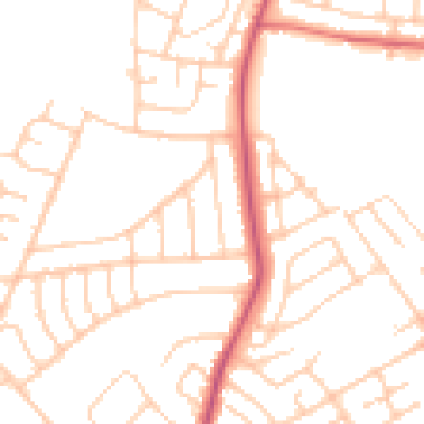
Daytime· 07:00 – 23:00
49.4dB

Night-time· 23:00 – 07:00
39.3dB