3 Harrington Road, Litherland, Liverpool, L21 7NA
About 3 Harrington Road
3 Harrington Road is a three-bedroom semi-detached house in Litherland, Liverpool, Liverpool (L21 7NA). It has a recorded floor area of 82 m² (around 879 sq ft), construction records dating it to 1950-1966 and council tax band A. The latest certificate (January 2011) shows an E (score 47), well below the UK norm with real room to improve. The recommended improvements would push it to D (score 64). The latest certificate is from January 2011, so improvements made since then won't be reflected.
Untraded for 19 years, with the last transfer in August 2007. That sale landed at the peak of the pre-credit-crunch market, which is a useful reference point when interpreting the price. It lags the bulk of the postcode on energy efficiency (less efficient than 82% of similar EPCs). Today's modelled estimate of £114,000 is 49% above the 2007 sale price.
What this property has
Inside
- Bedrooms3
- Dining roomYes
Outside
- Private gardenFront and rear
Building
- Heating systemGas
Everything you need to know about 3 Harrington Road
The true value, the hidden risks and the full sale history, in one report.
30-day money-back guarantee

The data behind every report


Energy performance
3 Harrington Road's carbon output runs well above what efficient homes in the postcode produce.
EPC Expired
This certificate is over 10 years old and is no longer valid.Expired 13 Jan 2021
EPC Rating
Planning history
3 Harrington Road has no planning applications on record.
The full report still covers planning activity across the surrounding area.
Sales history & valuation
The latest sale landed at the peak of the pre-credit-crunch market — a high-water reference point.
£114,000
Modelled from EPC, postcode comparables.
£76,500
Recorded with HM Land Registry.
Sales timeline
23 August 2007Most recent
£76,500
Median price across the last 5 sales in L21 7NA: £75,000 (2024–2012).
Nearby sales in L21 7NA
6 Harrington Road, Litherland, Liverpool, L21 7NA
Sold Sept 2024
£105,0009 Harrington Road, Litherland, Liverpool, L21 7NA
Sold Apr 2018
£75,00019 Harrington Road, Litherland, Liverpool, L21 7NA
Sold Aug 2017
£85,00017 Harrington Road, Litherland, Liverpool, L21 7NA
Sold Jun 2016
£75,00022 Harrington Road, Litherland, Liverpool, L21 7NA
Sold Nov 2010
£76,000
Versus other Harrington Road homes
3 Harrington Road is notably below the street on epc rating.
Price per m²
£937
Street avg £908
Floor Area
82 m²
Street avg 84 m²
Habitable Rooms
5 rooms
Street avg 5 rooms
CO₂ Emissions
6.0 t/year
Street avg 3.5 t/year
Everything you need to know about 3 Harrington Road
The true value, the hidden risks and the full sale history, in one report.
30-day money-back guarantee
The data behind every report
Similar properties nearby
1 Kent Avenue, Litherland
L21 7QJ
1 Amos Avenue
L21 7QH
1 Gale Road, Litherland
L21 7QR
1 Ruby Close, Litherland
L21 7RH
1 Amethyst Close, Litherland
L21 7RD
1 Boundary Road, Litherland
L21 7LA
1 Oxford Avenue
L21 7LT
1 Opal Close, Litherland
L21 7RE
The neighbourhood at a glance
Reported crime in the wider district is trending notably upward year-on-year.
Crime
4/mo
Rising year-on-year across the wider district.
Nearest stop
0.2 km
Boundary Road — bus stop.
Closest school
0.3 km
Litherland Moss Primary School. 38 schools nearby.
Go deeper on the local area
The full report breaks down crime, transport links, schools and air quality in depth.
Road noise across the postcode
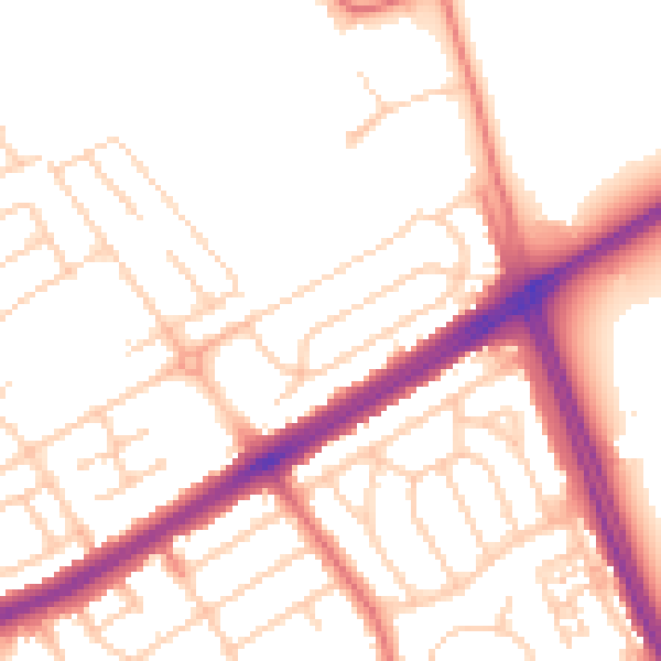
Daytime· 07:00 – 23:00
52.6dB

Night-time· 23:00 – 07:00
42.8dB