15 Kirkstone Road South, Liverpool, L21 5HJ
About 15 Kirkstone Road South
15 Kirkstone Road South is a three-bedroom semi-detached house in Liverpool (L21 5HJ). It has a recorded floor area of 86 m² (around 926 sq ft), construction records dating it to 1900-1929 and council tax band C. Tenure is freehold. The latest certificate (August 2021) shows an E (score 47), well below the UK norm with real room to improve. The recommended improvements would lift it to B (score 86), a 3-band jump.
Today's modelled estimate of £223,000 is 30.4% above the 2021 sale price. On a £-per-square-foot basis, the last sale (£185/sq ft) was about 48.5% above the typical sold price in the postcode. Most recent transfer: December 2021 at £171,000. That sale was during the post-pandemic price surge, when transactions cleared materially above pre-2020 trend.
What this property has
Inside
- Bedrooms3
- Bathrooms2
Outside
- Private gardenFront
- DrivewayYes
Building
- TenureFreehold
Everything you need to know about 15 Kirkstone Road South
The true value, the hidden risks and the full sale history, in one report.
30-day money-back guarantee

The data behind every report


Energy performance
Recommended upgrades on file would lift this property by multiple EPC bands.
EPC Rating
Planning history
15 Kirkstone Road South has no planning applications on record.
The full report still covers planning activity across the surrounding area.
Sales history & valuation
The latest sale landed in the post-pandemic price surge — useful context when reading the figure.
£223,000
Modelled from EPC, postcode comparables.
£171,000
Recorded with HM Land Registry.
Sales timeline
6 December 2021Most recent
£171,000
Median price across the last 5 sales in L21 5HJ: £220,000 (2024–2019).
Nearby sales in L21 5HJ
37 Kirkstone Road South, Liverpool, L21 5HJ
Sold Sept 2024
£130,0007 Kirkstone Road South, Liverpool, L21 5HJ
Sold Apr 2024
£220,00033 Kirkstone Road South, Liverpool, L21 5HJ
Sold Jun 2023
£235,0001 Kirkstone Road South, Liverpool, L21 5HJ
Sold Jun 2023
£268,0009 Kirkstone Road South, Liverpool, L21 5HJ
Sold Oct 2019
£195,000
Versus other Kirkstone Road South homes
15 Kirkstone Road South is notably below the street on epc rating.
Price per m²
£1,988
Street avg £1,720
Floor Area
86 m²
Street avg 105 m²
Habitable Rooms
5 rooms
Street avg 5 rooms
CO₂ Emissions
5.3 t/year
Street avg 5.5 t/year
Everything you need to know about 15 Kirkstone Road South
The true value, the hidden risks and the full sale history, in one report.
30-day money-back guarantee
The data behind every report
Similar properties nearby
10 Arnside
L21 5JH
1 Hawkshead Drive
L21 5JE
10 St Matthews Avenue
L21 5JS
11 Ennerdale Drive
L21 5HX
1 Silverdale Drive
L21 5HT
1 Ennerdale Drive
L21 5HX
10 Keswick Drive
L21 5JQ
1 Netherton Park Road
L21 5JD
The neighbourhood at a glance
Reported crime in the wider district is trending notably upward year-on-year.
Crime
4/mo
Rising year-on-year across the wider district.
Nearest stop
0.0 km
Eccleshall Avenue — bus stop.
Closest school
0.6 km
St Philip's Church of England Controlled Primary School. 41 schools nearby.
Go deeper on the local area
The full report breaks down crime, transport links, schools and air quality in depth.
Road noise across the postcode
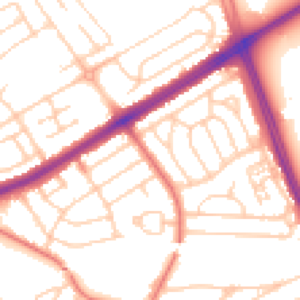
Daytime· 07:00 – 23:00
53.5dB

Night-time· 23:00 – 07:00
42.8dB