22 Norville Road, Liverpool, L14 3LY
About 22 Norville Road
22 Norville Road is a three-bedroom semi-detached house in Liverpool (L14 3LY). It has a recorded floor area of 91 m² (around 980 sq ft), construction records dating it to 1930-1949 and council tax band B. The latest certificate (November 2023) shows a D (score 64), on the cusp of jumping into the C band. The recommended improvements would lift it to B (score 85), a 2-band jump. Records show the property has been extended at some point in its history.
Today's modelled estimate of £255,000 is 24.4% above the 2024 sale price. On a £-per-square-foot basis, the last sale (£209/sq ft) was about 27.1% above the typical sold price in the postcode. Last sale on file: £205,000 in October 2024.
What this property has
Inside
- Bedrooms3
- Bathrooms1
Outside
- Private gardenRear
- ParkingOff road
Building
- Central heatingYes
- Previously extendedYes
Everything you need to know about 22 Norville Road
The true value, the hidden risks and the full sale history, in one report.
Pick your report · every report is £14.99
One time fee only - money back guarantee

The data behind every report


Energy performance
Recommended upgrades on file would lift this property by multiple EPC bands.
EPC Rating
Get a survey for this property
Level 3 Building Survey
Because the property has solid (non-cavity) walls, we believe a Level 3 building survey should be considered.
From £885 · Includes VAT
Planning history
22 Norville Road has no planning applications on record.
A planning report still maps activity across the surrounding area and reads this property's extension & conversion potential.
Sales history & valuation
22 Norville Road valuation sits well clear of the typical sold price in this postcode.
£255,000
Modelled from EPC, postcode comparables.
£205,000
Recorded with HM Land Registry.
Sales timeline
13 October 2024Most recent
£205,000
Median price across the last 5 sales in L14 3LY: £210,000 (2025–2019).
Nearby sales in L14 3LY
Versus other Norville Road homes
Years Held for 22 Norville Road lags the street by a wide margin.
Price per m²
£2,253
Street avg £1,894
Floor Area
91 m²
Street avg 93 m²
Habitable Rooms
5 rooms
Street avg 5 rooms
CO₂ Emissions
4.0 t/year
Street avg 5.0 t/year
Everything you need to know about 22 Norville Road
The true value, the hidden risks and the full sale history, in one report.
Pick your report · every report is £14.99
One time fee only - money back guarantee
The data behind every report
Similar properties nearby
1 Renville Road
L14 3LN
10 Hackworth Close
L14 3AB
10 Renville Road
L14 3LW
1 Old Thomas Lane
L14 3NA
10 Norville Road
L14 3LY
10 Orchard Avenue
L14 3NQ
1 Bowring Court, Roby Road, Bowring Park
L14 3NU
1 Staplands Road
L14 3LJ
The neighbourhood at a glance
Rail-style transport is unusually close for this postcode.
Crime
6/mo
Rising year-on-year across the wider district.
Nearest stop
0.2 km
Queens Drive — bus stop.
Closest school
0.5 km
Dixons Broadgreen Academy. 51 schools nearby.
Go deeper on the local area
A Local Area report breaks down crime, transport links, schools and air quality in depth.
Road noise across the postcode
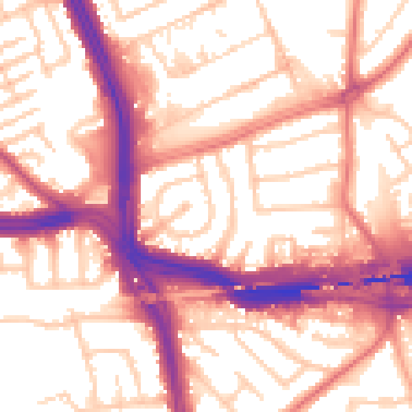
Daytime· 07:00 – 23:00
56.9dB
Night-time· 23:00 – 07:00
47.7dB