Flat, 273 Norwich Road, Ipswich, IP1 4BP
About Flat
Flat is a two-bedroom end-of-terrace house in Ipswich (IP1 4BP). It has a recorded floor area of 73 m² (around 786 sq ft), construction records dating it to before 1900 and council tax band A. At 73 m² this is the largest unit on EPC record across the building (35–73 m²). On EPC score it ranks first in the building (68 versus a worst of 61). The latest certificate (May 2019) shows a D (score 68), on the cusp of jumping into the C band. The rating has held steady at D across 2 certificates since June 2009. Between certificates, lighting went from Very Poor to Very Good; while roof efficiency dropped from Very Good to Good and window efficiency dropped from Good to Average. The recommended improvements would push it to C (score 73).
Untraded for 18 years, with the last transfer in February 2008. That sale landed at the peak of the pre-credit-crunch market, which is a useful reference point when interpreting the price. Across 2000–2008, sale prices on this property compounded at 16.7% per year. One historical planning record sits against the property in 2008.
What this property has
Inside
- Bedrooms2
- FireplaceYes
Outside
- GarageYes
Building
- Heating systemGas
- RefurbishedYes
Everything you need to know about Flat
The true value, the hidden risks and the full sale history, in one report.
Pick your report · from £14.99
One time fee only - money back guarantee

The data behind every report







Energy performance
EPC Rating
Certificate validity
Valid until 30 May 2029
Property Improvements
Changes detected from historical EPC data
Hot water efficiency decreased
More low energy lighting installed

Get a survey for this property
Level 3 Building Survey
Because the property was built before 1919 and has solid (non-cavity) walls, we believe a Level 3 building survey should be considered.
From £885 · Includes VAT
Planning history
1 application on record at Flat, 273 Norwich Road, Ipswich, IP1 4BP
- May 2008ExtensionFullOutcome in report
Extension: Single storey · Side of property
Erection of first floor side extension and alteration to rear and side elevations and change of use of part of first floor flat in conjunction with ground floor use.
- Documents
- 4 docs on file
- Reference
- 08/00284/FUL
Unlock Flat, 273 Norwich Road, Ipswich, IP1 4BP's full planning history
You're seeing the shape of it. The report has the substance.
- Every decision — granted, refused or withdrawn
- All 1 application on this property in full, plus 7 notable nearby
- The 4 documents, officer reports & conditions
- What the pattern means for extending or converting here
One time fee only - money back guarantee
Sales history & valuation
Flat has more than tripled in price since its earliest registered sale in 2000.
£255,000
Modelled from EPC, postcode comparables and a sale-price growth of 16.7% per year over 8 years.
£240,000
Growth on file: 16.7% per year over 8 years.
Sales timeline
27 February 2008Most recent
£240,000
+242.9%over 7 years3 March 2000
£70,000
Median price across the last 2 sales in IP1 4BP: £330,000 (2013–2011).
Nearby sales in IP1 4BP
Everything you need to know about Flat
The true value, the hidden risks and the full sale history, in one report.
Pick your report · from £14.99
One time fee only - money back guarantee
The data behind every report
Similar properties nearby
Flat 2, 220 Bramford Road
IP1 4AS
Flat 3, 336 Norwich Road
IP1 4HD
Flat 1, 336 Norwich Road
IP1 4HD
Flat 5, 74 Kitchener Road
IP1 4DT
Flat 2, 336 Norwich Road
IP1 4HD
Flat 1, 74 Kitchener Road
IP1 4DT
Flat, 308 Norwich Road
IP1 4HD
Flat 1, 1 All Saints Road
IP1 4DG
The neighbourhood at a glance
Crime
332/mo
Steady year-on-year across the wider district.
Nearest stop
0.1 km
Richmond Road — bus stop.
Closest school
0.3 km
Springfield Junior School. 28 schools nearby.
Go deeper on the local area
A Local Area report breaks down crime, transport links, schools and air quality in depth.
Road noise across the postcode
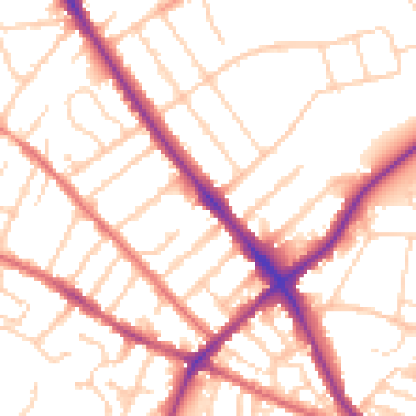
Daytime· 07:00 – 23:00
53.2dB

Night-time· 23:00 – 07:00
43.9dB